


chapelle

LUCIE2016
Gebruiker
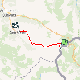

Lengte
11,7 km

Max. hoogte
2883 m

Positief hoogteverschil
78 m
Km-Effort
15,4 km

Min. hoogte
2027 m

Negatief hoogteverschil
895 m
Boucle
Neen
Datum van aanmaak :
2019-09-05 10:05:40.535
Laatste wijziging :
2019-09-06 06:41:10.324
3h55
Moeilijkheid : Moeilijk

Gratisgps-wandelapplicatie
 SityTrail
IGN / Geografische instituten
SityTrail Plus
De wereld gaat voor u open
Over ons
Tocht Stappen van 11,7 km beschikbaar op Piëmont, Cuneo, Pontechianale. Deze tocht wordt voorgesteld door LUCIE2016.
Plaatsbepaling
Land:
Italy
Regio :
Piëmont
Departement/Provincie :
Cuneo
Gemeente :
Pontechianale
Locatie:
Unknown
Vertrek:(Dec)
Vertrek:(UTM)
338173 ; 4948609 (32T) N.
Opmerkingen