![](/images/other/stat-length.png)
![Tocht Stappen Ottignies-Louvain-la-Neuve - Le Ruchaux et Profondval via le Col du Haut de Beaurieux - Photo](https://media.geolcdn.com/t/1900/400/ext.pjpeg?maxdim=2&url=https%3A%2F%2Fmedia.geolcdn.com%2Ff%2F3702c36e-22c3-4db7-8b8e-870d3f888f01.jpg)
Le Ruchaux et Profondval via le Col du Haut de Beaurieux
sguerit
Gebruiker
![Lengte](/images/other/stat-length.png)
Lengte
4,6 km
![Max. hoogte](https://static1.geolcdn.com/siteimages/upload/files/1508320355ic_sort_altitude_max_24dp.png)
Max. hoogte
146 m
![Positief hoogteverschil](https://static1.geolcdn.com/siteimages/upload/files/1508320355ic_sort_den_pos_24dp.png)
Positief hoogteverschil
90 m
![Km-Effort](/images/other/stat-length.png)
Km-Effort
5,8 km
![Min. hoogte](https://static1.geolcdn.com/siteimages/upload/files/1508320355ic_sort_altitude_min_24dp.png)
Min. hoogte
94 m
![Negatief hoogteverschil](https://static1.geolcdn.com/siteimages/upload/files/1508320355ic_sort_den_neg_24dp.png)
Negatief hoogteverschil
90 m
![Boucle](https://static1.geolcdn.com/siteimages/upload/files/16400158638029165_repeat_loop_refresh_sync_direction_icon.png)
Boucle
Ja
Datum van aanmaak :
2021-01-15 19:19:55.141
Laatste wijziging :
2021-01-16 15:07:32.026
![Stappen](https://static1.geolcdn.com/sitytour/trail-icons/101.png)
1h39
Moeilijkheid : Medium
![Scan deze QR-code om de tocht te openen in de SityTrail-applicatie](https://capi.geolives.com/qq0zvz2zws4bq2lad0pu/sitytour/trails/2641772/qr.png?size=200)
Gratisgps-wandelapplicatie
Over ons
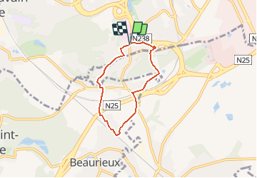
Tocht Stappen van 4,6 km beschikbaar op Wallonië, Waals-Brabant, Ottignies-Louvain-la-Neuve. Deze tocht wordt voorgesteld door sguerit.
Beschrijving
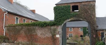
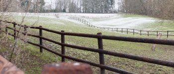
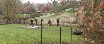
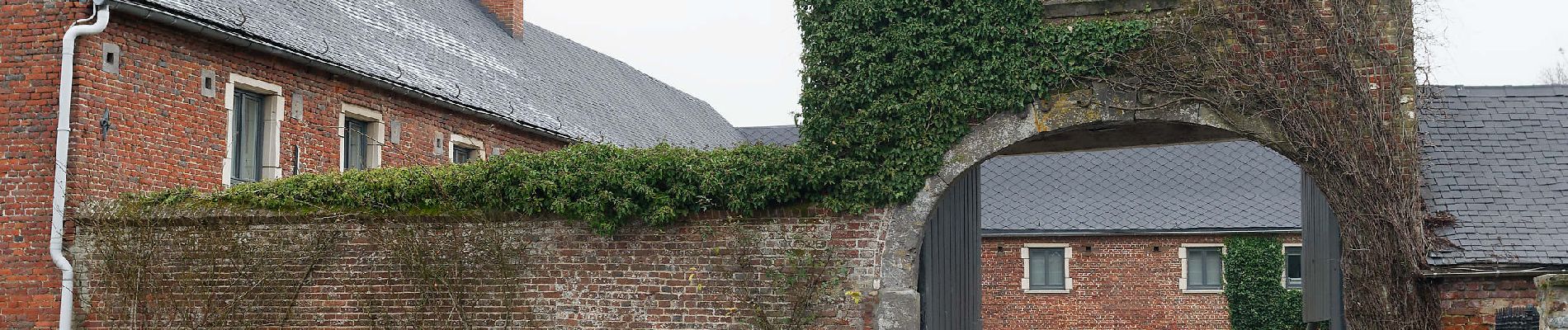
Balade de 4,6 km autour du Ruchaux et de la ferme de Profondval. Les chemins et sentiers empruntés sont peu fréquentés et offrent un aperçu champêtre de ce coin situé à deux pas de Louvain-la-Neuve.
Plaatsbepaling
Land:
Belgium
Regio :
Wallonië
Departement/Provincie :
Waals-Brabant
Gemeente :
Ottignies-Louvain-la-Neuve
Locatie:
Ottignies
Vertrek:(Dec)
Vertrek:(UTM)
613342 ; 5613160 (31U) N.
Opmerkingen
Wandeltochten in de omgeving
![Tocht Stappen Ottignies-Louvain-la-Neuve - Nuit du scoutisme - Louvain-la-Neuve - Photo](https://media.geolcdn.com/t/375/260/ext.jpg?maxdim=2&url=https%3A%2F%2Fmedia.geolcdn.com%2Ff%2Fa66232ef-7471-42b4-b6aa-97b05d528647.jpg)
![Stappen Stappen](https://static1.geolcdn.com/sitytour/trail-icons/101.png)
Nuit du scoutisme - Louvain-la-Neuve
Stappen
Medium
(16)
Ottignies-Louvain-la-Neuve,
Wallonië,
Waals-Brabant,
Belgium
![](/images/other/stat-length.png)
5,7 km | 6,7 km-effort
1h 27min
![](https://static1.geolcdn.com/siteimages/upload/files/16400158638029165_repeat_loop_refresh_sync_direction_icon.png)
Ja
![Tocht Stappen Chaumont-Gistoux - De Dion-le Mont à Dion-le Val par la vallée du Pisselet - Photo](https://media.geolcdn.com/t/375/260/ext.jpg?maxdim=2&url=https%3A%2F%2Fstatic1.geolcdn.com%2Fsiteimages%2Fupload%2Ffiles%2F1553511878bg_sport_marche.png)
![Stappen Stappen](https://static1.geolcdn.com/sitytour/trail-icons/101.png)
De Dion-le Mont à Dion-le Val par la vallée du Pisselet
Stappen
Heel gemakkelijk
(8)
Chaumont-Gistoux,
Wallonië,
Waals-Brabant,
Belgium
![](/images/other/stat-length.png)
8,6 km | 10,3 km-effort
2h 0min
![](https://static1.geolcdn.com/siteimages/upload/files/16400158638029165_repeat_loop_refresh_sync_direction_icon.png)
Ja
![Tocht Stappen Ottignies-Louvain-la-Neuve - GG-Bw-02_Céroux-Mousty - Villers-la-Ville - Photo](https://media.geolcdn.com/t/375/260/ext.jpg?maxdim=2&url=https%3A%2F%2Fmedia.geolcdn.com%2Ff%2F9dc1100d-f11d-446a-a492-1a8c831ce762.jpg)
![Stappen Stappen](https://static1.geolcdn.com/sitytour/trail-icons/101.png)
GG-Bw-02_Céroux-Mousty - Villers-la-Ville
Stappen
Zeer moeilijk
(2)
Ottignies-Louvain-la-Neuve,
Wallonië,
Waals-Brabant,
Belgium
![](/images/other/stat-length.png)
20 km | 26 km-effort
5h 37min
![](https://static1.geolcdn.com/siteimages/upload/files/16400158638029165_repeat_loop_refresh_sync_direction_icon.png)
Neen
![Tocht Stappen Mont-Saint-Guibert - Balade à Mont-Saint-Guibert - Photo](https://media.geolcdn.com/t/375/260/ext.jpg?maxdim=2&url=https%3A%2F%2Fservices.sitytrail.com%2FGeolivesWS%2FDownloadMedia.ashx%3FTrailID%3D942864%26Media%3D4a857fe0-cf43-4eb8-b563-62b2b90d4fc2.jpg)
![Stappen Stappen](https://static1.geolcdn.com/sitytour/trail-icons/101.png)
Balade à Mont-Saint-Guibert
Stappen
Heel gemakkelijk
(1)
Mont-Saint-Guibert,
Wallonië,
Waals-Brabant,
Belgium
![](/images/other/stat-length.png)
8,4 km | 10,1 km-effort
2h 12min
![](https://static1.geolcdn.com/siteimages/upload/files/16400158638029165_repeat_loop_refresh_sync_direction_icon.png)
Ja
![Tocht Stappen Ottignies-Louvain-la-Neuve - Balade dans le Bois de Lauzelle - Photo](https://media.geolcdn.com/t/375/260/ext.jpg?maxdim=2&url=https%3A%2F%2Fservices.sitytrail.com%2FGeolivesWS%2FDownloadMedia.ashx%3FTrailID%3D652718%26Media%3Dfe46824b-6e61-4100-b5d8-1f34a923c154.jpg)
![Stappen Stappen](https://static1.geolcdn.com/sitytour/trail-icons/101.png)
Balade dans le Bois de Lauzelle
Stappen
Heel gemakkelijk
(1)
Ottignies-Louvain-la-Neuve,
Wallonië,
Waals-Brabant,
Belgium
![](/images/other/stat-length.png)
6,3 km | 8,1 km-effort
1h 44min
![](https://static1.geolcdn.com/siteimages/upload/files/16400158638029165_repeat_loop_refresh_sync_direction_icon.png)
Ja
![Tocht Stappen Ottignies-Louvain-la-Neuve - Lauzelle - Circuit Natura 2000, des sites qui valent le détour ! - Bw01 - Photo](https://media.geolcdn.com/t/375/260/ext.jpg?maxdim=2&url=https%3A%2F%2Fmedia.geolcdn.com%2Ff%2F648550f3-d9ef-4b6f-9933-939a57e593f5.JPG)
![Stappen Stappen](https://static1.geolcdn.com/sitytour/trail-icons/101.png)
Lauzelle - Circuit Natura 2000, des sites qui valent le détour ! - Bw01
Stappen
Gemakkelijk
(2)
Ottignies-Louvain-la-Neuve,
Wallonië,
Waals-Brabant,
Belgium
![](/images/other/stat-length.png)
3,8 km | 4,8 km-effort
1h 26min
![](https://static1.geolcdn.com/siteimages/upload/files/16400158638029165_repeat_loop_refresh_sync_direction_icon.png)
Ja
![Tocht Stappen Court-Saint-Étienne - RB-BW-08 - À la rencontre de trois vallées - Photo](https://media.geolcdn.com/t/375/260/ext.jpg?maxdim=2&url=https%3A%2F%2Fservices.sitytrail.com%2FGeolivesWS%2FDownloadMedia.ashx%3FTrailID%3D220267%26Media%3D6c86831f-6220-45af-ac63-82e6ea37f2ed.jpg)
![Stappen Stappen](https://static1.geolcdn.com/sitytour/trail-icons/101.png)
RB-BW-08 - À la rencontre de trois vallées
Stappen
Zeer moeilijk
(2)
Court-Saint-Étienne,
Wallonië,
Waals-Brabant,
Belgium
![](/images/other/stat-length.png)
26 km | 32 km-effort
7h 18min
![](https://static1.geolcdn.com/siteimages/upload/files/16400158638029165_repeat_loop_refresh_sync_direction_icon.png)
Ja
![Tocht Stappen Chastre - #240223a - Blanmont, Orne, Alvaux, Nil Pierreux*** - Photo](https://media.geolcdn.com/t/375/260/ext.jpg?maxdim=2&url=https%3A%2F%2Fmedia.geolcdn.com%2Ff%2F93f4f268-f0dd-4755-9fda-3b9155347db7.JPG)
![Stappen Stappen](https://static1.geolcdn.com/sitytour/trail-icons/101.png)
#240223a - Blanmont, Orne, Alvaux, Nil Pierreux***
Stappen
Medium
(1)
Chastre,
Wallonië,
Waals-Brabant,
Belgium
![](/images/other/stat-length.png)
6,6 km | 7,8 km-effort
1h 47min
![](https://static1.geolcdn.com/siteimages/upload/files/16400158638029165_repeat_loop_refresh_sync_direction_icon.png)
Ja
![Tocht Stappen Chaumont-Gistoux - #231016 - Corroy-Le-Grand et le Val d'Ocquière*** (inversé court) - Photo](https://media.geolcdn.com/t/375/260/ext.jpg?maxdim=2&url=https%3A%2F%2Fmedia.geolcdn.com%2Ff%2Fb650de28-d96e-49f2-85c2-d640aecfc352.jpg)
![Stappen Stappen](https://static1.geolcdn.com/sitytour/trail-icons/101.png)
#231016 - Corroy-Le-Grand et le Val d'Ocquière*** (inversé court)
Stappen
Medium
(2)
Chaumont-Gistoux,
Wallonië,
Waals-Brabant,
Belgium
![](/images/other/stat-length.png)
6,2 km | 7,2 km-effort
1h 38min
![](https://static1.geolcdn.com/siteimages/upload/files/16400158638029165_repeat_loop_refresh_sync_direction_icon.png)
Ja