Tocht Stappen Saillagouse - 20210627 à partir de Saillagouse  - Photo

20210627 à partir de Saillagouse

 ThonyM
ThonyM

Gebruiker

© OpenStreetMap contributors
Lengte
Lengte
16,2 km
Max. hoogte
Max. hoogte
1982 m
Positief hoogteverschil
722 m
Km-Effort
Km-Effort  
26 km
Min. hoogte
Min. hoogte
1301 m
Negatief hoogteverschil
719 m
Boucle
Boucle
Ja
Datum van aanmaak :
2021-06-27 06:28:16.0
Laatste wijziging :
2021-06-27 11:21:13.486

(1 Bericht)

Stappen
Stappen
3h47
Moeilijkheid : Medium

Scan deze QR-code om de tocht te openen in de SityTrail-applicatie

Gratisgps-wandelapplicatie

Logo SityTrail SityTrail

IGN / Geografische instituten

SityTrail uit de App Store downloaden SityTrail uit Google Play downloaden

Logo SityTrail SityTrail World

De wereld gaat voor u open

SityTrail uit de App Store downloaden SityTrail uit Google Play downloaden SityTrail op Huawei AppGallery downloaden

Over ons

Tocht Stappen van 16,2 km beschikbaar op Occitanië, Pyrénées-Orientales, Saillagouse. Deze tocht wordt voorgesteld door ThonyM.

Beschrijving

Les 700m  sur les premiers 7 km. Tres belle vues sur Saillagouse

Hoogteprofiel

Foto's

Plaatsbepaling

Land:
France
Regio :
Occitanië
Departement/Provincie :
Pyrénées-Orientales
Gemeente :
Saillagouse
Locatie:
Unknown
Vertrek:(Dec)
Vertrek:(UTM)
420879 ; 4701033 (31T) N.

Opmerkingen

Gelieve in te loggen om een commentaar of een beoordeling achter te laten


Randonnée sympa avec retour par la forêt, de bien beaux papillons observables tout au long du trajet.


Wandeltochten in de omgeving

Tocht Stappen Nahuja - boucle de Nahuja - Photo
Stappen
crijack

Stappen

Medium
(1)
Nahuja, Occitanië, Pyrénées-Orientales, France
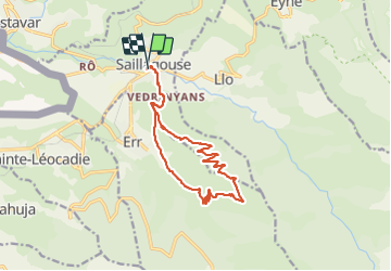
11,8 km | 18,2 km-effort
2h 44min
Ja
Tocht Stappen Eyne - Eyne,col de Nuria,pic d'Eyne,Torre d'Eyne,Eyne. - Photo
Stappen
Machaon6

Stappen

Zeer moeilijk
(1)
Eyne, Occitanië, Pyrénées-Orientales, France
24 km | 43 km-effort
8h 44min
Ja
Tocht Stappen Font-Romeu-Odeillo-Via - Font Romeu Egat - Photo
Stappen
crijack

Stappen

Medium
(2)
Font-Romeu-Odeillo-Via, Occitanië, Pyrénées-Orientales, France
2,5 km | 3,4 km-effort
44min
Ja
Tocht Stappen Eyne - Vallée d'Eyne - Photo
Stappen
GUIDE
nadinebondoux

Stappen

Medium
Eyne, Occitanië, Pyrénées-Orientales, France
10,7 km | 17,6 km-effort
4h 40min
Ja
Tocht Stappen Eyne - eyne - Photo
Stappen
gardelg

Stappen

Medium
(2)
Eyne, Occitanië, Pyrénées-Orientales, France
6,2 km | 8,2 km-effort
2h 1min
Ja
Tocht Stappen Eyne - La vallée d'Eyne - Photo
Stappen
suresnois

Stappen

Moeilijk
Eyne, Occitanië, Pyrénées-Orientales, France
11,2 km | 18 km-effort
7h 8min
Ja
Tocht Stappen Estavar - 20220328 Estavar-Tartassonne(?) - Photo
Stappen
ThonyM

Stappen

Medium
Estavar, Occitanië, Pyrénées-Orientales, France
14,8 km | 22 km-effort
3h 16min
Ja
Tocht Stappen Eyne - 20210722 vallée d’Eyne-Pic de Nuria et Finestrelle - Photo
Stappen
ThonyM

Stappen

Moeilijk
Eyne, Occitanië, Pyrénées-Orientales, France
21 km | 37 km-effort
5h 56min
Ja
Tocht Trail Font-Romeu-Odeillo-Via - Sortie trail - Photo
Trail
Cedric Pucheux

Trail

Moeilijk
(1)
Font-Romeu-Odeillo-Via, Occitanië, Pyrénées-Orientales, France
11,8 km | 17,8 km-effort
1h 37min
Ja


Sluiten
Mijn abonnementen