![](/images/other/stat-length.png)
![Tocht Hybride fiets Villers-Saint-Frambourg-Ognon - 2021-09-30_13h10m38_boucle_2_pnr_halatte - Photo](https://media.geolcdn.com/t/1900/400/ext.pjpeg?maxdim=2&url=https%3A%2F%2Fstatic1.geolcdn.com%2Fsiteimages%2Fupload%2Ffiles%2F1524743154velo.jpg)
2021-09-30_13h10m38_boucle_2_pnr_halatte
gilbertdu60
Gebruiker
![Lengte](/images/other/stat-length.png)
Lengte
22 km
![Max. hoogte](https://static1.geolcdn.com/siteimages/upload/files/1508320355ic_sort_altitude_max_24dp.png)
Max. hoogte
150 m
![Positief hoogteverschil](https://static1.geolcdn.com/siteimages/upload/files/1508320355ic_sort_den_pos_24dp.png)
Positief hoogteverschil
302 m
![Km-Effort](/images/other/stat-length.png)
Km-Effort
26 km
![Min. hoogte](https://static1.geolcdn.com/siteimages/upload/files/1508320355ic_sort_altitude_min_24dp.png)
Min. hoogte
86 m
![Negatief hoogteverschil](https://static1.geolcdn.com/siteimages/upload/files/1508320355ic_sort_den_neg_24dp.png)
Negatief hoogteverschil
304 m
![Boucle](https://static1.geolcdn.com/siteimages/upload/files/16400158638029165_repeat_loop_refresh_sync_direction_icon.png)
Boucle
Ja
Datum van aanmaak :
2021-09-30 11:10:38.555
Laatste wijziging :
2022-05-09 16:37:55.208
![Hybride fiets](https://static1.geolcdn.com/sitytour/trail-icons/203.png)
2h00
Moeilijkheid : Gemakkelijk
![Scan deze QR-code om de tocht te openen in de SityTrail-applicatie](https://capi.geolives.com/qq0zvz2zws4bq2lad0pu/sitytour/trails/2954354/qr.png?size=200)
Gratisgps-wandelapplicatie
Over ons
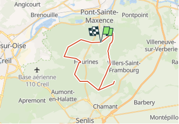
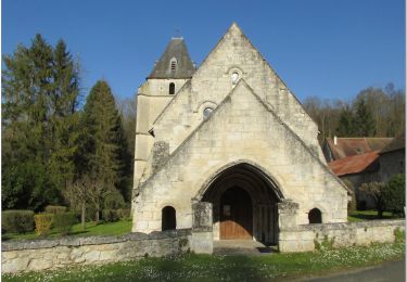
Tocht Hybride fiets van 22 km beschikbaar op Hauts-de-France, Oise, Villers-Saint-Frambourg-Ognon. Deze tocht wordt voorgesteld door gilbertdu60.
Beschrijving
Randonnée V.T.C. de 22 km . Cette randonnée est proposée par O.T CCPOH et AU5V.
Plaatsbepaling
Land:
France
Regio :
Hauts-de-France
Departement/Provincie :
Oise
Gemeente :
Villers-Saint-Frambourg-Ognon
Locatie:
Unknown
Vertrek:(Dec)
Vertrek:(UTM)
471426 ; 5458370 (31U) N.
Opmerkingen
Wandeltochten in de omgeving
![Tocht Stappen Villers-Saint-Frambourg-Ognon - MR_OGNON (par BALAGNY-sur-AUNETTE)_5.4Km - Photo](https://media.geolcdn.com/t/375/260/ext.jpg?maxdim=2&url=https%3A%2F%2Fmedia.geolcdn.com%2Ff%2Ffaa42a0c-203b-4c6a-9068-84728c6debbe.jpg)
![Stappen Stappen](https://static1.geolcdn.com/sitytour/trail-icons/101.png)
MR_OGNON (par BALAGNY-sur-AUNETTE)_5.4Km
Stappen
Medium
(3)
Villers-Saint-Frambourg-Ognon,
Hauts-de-France,
Oise,
France
![](/images/other/stat-length.png)
5,4 km | 6,4 km-effort
1h 27min
![](https://static1.geolcdn.com/siteimages/upload/files/16400158638029165_repeat_loop_refresh_sync_direction_icon.png)
Ja
![Tocht Stappen Beaurepaire - La mare aux oiseaux - Beaurepaire - Photo](https://media.geolcdn.com/t/375/260/ext.jpg?maxdim=2&url=https%3A%2F%2Fservices.sitytrail.com%2FGeolivesWS%2FDownloadMedia.ashx%3FTrailID%3D172831%26Media%3D14265_3.jpg)
![Stappen Stappen](https://static1.geolcdn.com/sitytour/trail-icons/101.png)
La mare aux oiseaux - Beaurepaire
Stappen
Medium
(1)
Beaurepaire,
Hauts-de-France,
Oise,
France
![](/images/other/stat-length.png)
8,4 km | 10,2 km-effort
2h 10min
![](https://static1.geolcdn.com/siteimages/upload/files/16400158638029165_repeat_loop_refresh_sync_direction_icon.png)
Ja
![Tocht Stappen Fleurines - Fleurines Grand parcours - Photo](https://media.geolcdn.com/t/375/260/ext.jpg?maxdim=2&url=https%3A%2F%2Fstatic1.geolcdn.com%2Fsiteimages%2Fupload%2Ffiles%2F1553511878bg_sport_marche.png)
![Stappen Stappen](https://static1.geolcdn.com/sitytour/trail-icons/101.png)
Fleurines Grand parcours
Stappen
Gemakkelijk
(1)
Fleurines,
Hauts-de-France,
Oise,
France
![](/images/other/stat-length.png)
20 km | 24 km-effort
5h 8min
![](https://static1.geolcdn.com/siteimages/upload/files/16400158638029165_repeat_loop_refresh_sync_direction_icon.png)
Ja
![Tocht Stappen Chamant - Chamant Supermini-rando - Photo](https://media.geolcdn.com/t/375/260/ext.jpg?maxdim=2&url=https%3A%2F%2Fstatic1.geolcdn.com%2Fsiteimages%2Fupload%2Ffiles%2F1553511878bg_sport_marche.png)
![Stappen Stappen](https://static1.geolcdn.com/sitytour/trail-icons/101.png)
Chamant Supermini-rando
Stappen
Gemakkelijk
(8)
Chamant,
Hauts-de-France,
Oise,
France
![](/images/other/stat-length.png)
8 km | 9,3 km-effort
2h 7min
![](https://static1.geolcdn.com/siteimages/upload/files/16400158638029165_repeat_loop_refresh_sync_direction_icon.png)
Ja
![Tocht Stappen Pontpoint - Mont Pagnotte Grand parcours - Photo](https://media.geolcdn.com/t/375/260/ext.jpg?maxdim=2&url=https%3A%2F%2Fstatic1.geolcdn.com%2Fsiteimages%2Fupload%2Ffiles%2F1553511878bg_sport_marche.png)
![Stappen Stappen](https://static1.geolcdn.com/sitytour/trail-icons/101.png)
Mont Pagnotte Grand parcours
Stappen
Medium
(2)
Pontpoint,
Hauts-de-France,
Oise,
France
![](/images/other/stat-length.png)
16,6 km | 22 km-effort
4h 36min
![](https://static1.geolcdn.com/siteimages/upload/files/16400158638029165_repeat_loop_refresh_sync_direction_icon.png)
Ja
![Tocht Hybride fiets Fleurines - randonnée Au5v OT Ccpoh halatte - Photo](https://media.geolcdn.com/t/375/260/ext.jpg?maxdim=2&url=https%3A%2F%2Fmedia.geolcdn.com%2Ff%2Fe4619b64-6ffd-453c-8063-35f7d7e4513e.jpg)
![Hybride fiets Hybride fiets](https://static1.geolcdn.com/sitytour/trail-icons/203.png)
randonnée Au5v OT Ccpoh halatte
Hybride fiets
Gemakkelijk
Fleurines,
Hauts-de-France,
Oise,
France
![](/images/other/stat-length.png)
30 km | 35 km-effort
Onbekend
![](https://static1.geolcdn.com/siteimages/upload/files/16400158638029165_repeat_loop_refresh_sync_direction_icon.png)
Ja
![Tocht Fietstoerisme Pont-Sainte-Maxence - sortie AU5v Pentecôte 2022 - Photo](https://media.geolcdn.com/t/375/260/ext.jpg?maxdim=2&url=https%3A%2F%2Fmedia.geolcdn.com%2Ff%2F72742583-c7e6-4761-a433-7f77fdf4fdf5.jpg)
![Fietstoerisme Fietstoerisme](https://static1.geolcdn.com/sitytour/trail-icons/204.png)
sortie AU5v Pentecôte 2022
Fietstoerisme
Gemakkelijk
Pont-Sainte-Maxence,
Hauts-de-France,
Oise,
France
![](/images/other/stat-length.png)
26 km | 29 km-effort
Onbekend
![](https://static1.geolcdn.com/siteimages/upload/files/16400158638029165_repeat_loop_refresh_sync_direction_icon.png)
Ja
![Tocht Te voet Pont-Sainte-Maxence - balade pedestre 11 avril 2022 - Photo](https://media.geolcdn.com/t/375/260/ext.jpg?maxdim=2&url=https%3A%2F%2Fmedia.geolcdn.com%2Ff%2F80b47c68-2cf3-4ca1-99f4-54eb29551880.jpg)
![Te voet Te voet](https://static1.geolcdn.com/sitytour/trail-icons/100.png)
balade pedestre 11 avril 2022
Te voet
Gemakkelijk
Pont-Sainte-Maxence,
Hauts-de-France,
Oise,
France
![](/images/other/stat-length.png)
7,2 km | 9,1 km-effort
2h 4min
![](https://static1.geolcdn.com/siteimages/upload/files/16400158638029165_repeat_loop_refresh_sync_direction_icon.png)
Ja
![Tocht Elektrische fiets Pont-Sainte-Maxence - balade printanière du 23 mars - Photo](https://media.geolcdn.com/t/375/260/ext.jpg?maxdim=2&url=https%3A%2F%2Fmedia.geolcdn.com%2Ff%2F91c5558e-d792-4457-81d8-689705073d14.jpg)
![Elektrische fiets Elektrische fiets](https://static1.geolcdn.com/sitytour/trail-icons/205.png)
balade printanière du 23 mars
Elektrische fiets
Gemakkelijk
Pont-Sainte-Maxence,
Hauts-de-France,
Oise,
France
![](/images/other/stat-length.png)
22 km | 26 km-effort
2h 14min
![](https://static1.geolcdn.com/siteimages/upload/files/16400158638029165_repeat_loop_refresh_sync_direction_icon.png)
Ja