![](/images/other/stat-length.png)
![Tocht Te voet Santa Cristina Gherdëina - St. Christina in Gröden - Santa Cristina Valgardena - IT-527 - Photo](https://media.geolcdn.com/t/1900/400/ext.pjpeg?maxdim=2&url=https%3A%2F%2Fmedia.geolcdn.com%2Ff%2F66ec401f-7704-46ae-a707-b2c52b0961cf.jpeg)
IT-527
SityTrail - itinéraires balisés pédestres
Tous les sentiers balisés d’Europe PRO
![Lengte](/images/other/stat-length.png)
Lengte
6,4 km
![Max. hoogte](https://static1.geolcdn.com/siteimages/upload/files/1508320355ic_sort_altitude_max_24dp.png)
Max. hoogte
2922 m
![Positief hoogteverschil](https://static1.geolcdn.com/siteimages/upload/files/1508320355ic_sort_den_pos_24dp.png)
Positief hoogteverschil
967 m
![Km-Effort](/images/other/stat-length.png)
Km-Effort
16,5 km
![Min. hoogte](https://static1.geolcdn.com/siteimages/upload/files/1508320355ic_sort_altitude_min_24dp.png)
Min. hoogte
1943 m
![Negatief hoogteverschil](https://static1.geolcdn.com/siteimages/upload/files/1508320355ic_sort_den_neg_24dp.png)
Negatief hoogteverschil
131 m
![Boucle](https://static1.geolcdn.com/siteimages/upload/files/16400158638029165_repeat_loop_refresh_sync_direction_icon.png)
Boucle
Neen
Markering
Datum van aanmaak :
2022-02-14 23:02:47.624
Laatste wijziging :
2022-02-28 16:58:53.892
![Te voet](https://static1.geolcdn.com/sitytour/trail-icons/100.png)
3h45
Moeilijkheid : Gemakkelijk
![Scan deze QR-code om de tocht te openen in de SityTrail-applicatie](https://capi.geolives.com/qq0zvz2zws4bq2lad0pu/sitytour/trails/3112311/qr.png?size=200)
Gratisgps-wandelapplicatie
Over ons
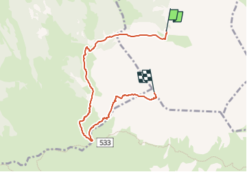
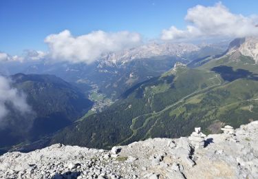
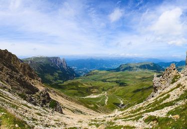
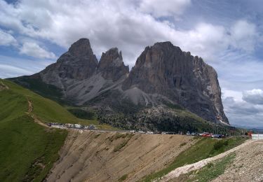
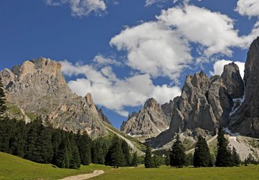
Tocht Te voet van 6,4 km beschikbaar op Trento-Zuid-Tirol, Bolzano - Bozen, Santa Cristina Gherdëina - St. Christina in Gröden - Santa Cristina Valgardena. Deze tocht wordt voorgesteld door SityTrail - itinéraires balisés pédestres.
Beschrijving
Trail created by Alpenverein Südtirol (AVS).
Symbol: 527 on white red flag
Plaatsbepaling
Land:
Italy
Regio :
Trento-Zuid-Tirol
Departement/Provincie :
Bolzano - Bozen
Gemeente :
Santa Cristina Gherdëina - St. Christina in Gröden - Santa Cristina Valgardena
Locatie:
Unknown
Vertrek:(Dec)
Vertrek:(UTM)
708567 ; 5155838 (32T) N.
Opmerkingen
Wandeltochten in de omgeving
![Tocht Te voet Sëlva - Wolkenstein - Selva di Val Gardena - (SI C21N) Selva di Val Gardena - Rifugio Puez - Photo](https://media.geolcdn.com/t/375/260/ext.jpg?maxdim=2&url=https%3A%2F%2Fmedia.geolcdn.com%2Ff%2F37a3edca-92b3-4b7c-b813-71fb6d1f0fc5.jpeg)
![Te voet Te voet](https://static1.geolcdn.com/sitytour/trail-icons/100.png)
(SI C21N) Selva di Val Gardena - Rifugio Puez
Te voet
Gemakkelijk
Sëlva - Wolkenstein - Selva di Val Gardena,
Trento-Zuid-Tirol,
Bolzano - Bozen,
Italy
![](/images/other/stat-length.png)
8,9 km | 18,2 km-effort
4h 8min
![](https://static1.geolcdn.com/siteimages/upload/files/16400158638029165_repeat_loop_refresh_sync_direction_icon.png)
Neen
![Tocht Te voet Kastelruth - Castelrotto - (SI C20N) Rifugio Sasso Piatto - Selva di Val Gardena - Photo](https://media.geolcdn.com/t/375/260/ext.jpg?maxdim=2&url=https%3A%2F%2Fmedia.geolcdn.com%2Ff%2Fc85139c0-2958-45f8-bcef-f4dced1d6466.jpeg)
![Te voet Te voet](https://static1.geolcdn.com/sitytour/trail-icons/100.png)
(SI C20N) Rifugio Sasso Piatto - Selva di Val Gardena
Te voet
Medium
Kastelruth - Castelrotto,
Trento-Zuid-Tirol,
Bolzano - Bozen,
Italy
![](/images/other/stat-length.png)
13,2 km | 20 km-effort
4h 37min
![](https://static1.geolcdn.com/siteimages/upload/files/16400158638029165_repeat_loop_refresh_sync_direction_icon.png)
Neen
![Tocht Te voet Campitello di Fassa - IT-E530 - Photo](https://media.geolcdn.com/t/375/260/ext.jpg?maxdim=2&url=https%3A%2F%2Fmedia.geolcdn.com%2Ff%2F3e155fb9-7e5d-49a9-a83f-53914272f481.jpeg)
![Te voet Te voet](https://static1.geolcdn.com/sitytour/trail-icons/100.png)
IT-E530
Te voet
Gemakkelijk
Campitello di Fassa,
Trento-Zuid-Tirol,
Provincia di Trento,
Italy
![](/images/other/stat-length.png)
4,2 km | 7,4 km-effort
1h 40min
![](https://static1.geolcdn.com/siteimages/upload/files/16400158638029165_repeat_loop_refresh_sync_direction_icon.png)
Neen
![Tocht Te voet Campitello di Fassa - IT-E529 - Photo](https://media.geolcdn.com/t/375/260/ext.jpg?maxdim=2&url=https%3A%2F%2Fmedia.geolcdn.com%2Ff%2F76cbb70e-0f0d-494f-aa0c-106286d7ace6.jpeg)
![Te voet Te voet](https://static1.geolcdn.com/sitytour/trail-icons/100.png)
IT-E529
Te voet
Gemakkelijk
Campitello di Fassa,
Trento-Zuid-Tirol,
Provincia di Trento,
Italy
![](/images/other/stat-length.png)
4,4 km | 7,6 km-effort
1h 43min
![](https://static1.geolcdn.com/siteimages/upload/files/16400158638029165_repeat_loop_refresh_sync_direction_icon.png)
Neen
![Tocht Te voet Campitello di Fassa - IT-E594 - Photo](https://media.geolcdn.com/t/375/260/ext.jpg?maxdim=2&url=https%3A%2F%2Fmedia.geolcdn.com%2Ff%2F2b3b6c37-933d-47c7-866c-9c42000bd74c.jpeg)
![Te voet Te voet](https://static1.geolcdn.com/sitytour/trail-icons/100.png)
IT-E594
Te voet
Gemakkelijk
Campitello di Fassa,
Trento-Zuid-Tirol,
Provincia di Trento,
Italy
![](/images/other/stat-length.png)
6,5 km | 10,8 km-effort
2h 26min
![](https://static1.geolcdn.com/siteimages/upload/files/16400158638029165_repeat_loop_refresh_sync_direction_icon.png)
Neen
![Tocht Te voet Campitello di Fassa - IT-E532 - Photo](https://media.geolcdn.com/t/375/260/ext.jpg?maxdim=2&url=https%3A%2F%2Fmedia.geolcdn.com%2Ff%2Fed5e65c0-dab7-4e17-a5e4-9d5cddf98cc0.jpeg)
![Te voet Te voet](https://static1.geolcdn.com/sitytour/trail-icons/100.png)
IT-E532
Te voet
Gemakkelijk
Campitello di Fassa,
Trento-Zuid-Tirol,
Provincia di Trento,
Italy
![](/images/other/stat-length.png)
5,7 km | 9,3 km-effort
2h 6min
![](https://static1.geolcdn.com/siteimages/upload/files/16400158638029165_repeat_loop_refresh_sync_direction_icon.png)
Neen
![Tocht Te voet Canazei - Sentiero](https://media.geolcdn.com/t/375/260/ext.jpg?maxdim=2&url=https%3A%2F%2Fmedia.geolcdn.com%2Ff%2F8b3c1857-30be-43ed-81a6-50f6b5f6c3e2.jpeg)
![Te voet Te voet](https://static1.geolcdn.com/sitytour/trail-icons/100.png)
Sentiero "Friedrich August" - Friedrich August Weg
Te voet
Gemakkelijk
Canazei,
Trento-Zuid-Tirol,
Provincia di Trento,
Italy
![](/images/other/stat-length.png)
6,6 km | 10,1 km-effort
2h 17min
![](https://static1.geolcdn.com/siteimages/upload/files/16400158638029165_repeat_loop_refresh_sync_direction_icon.png)
Neen
![Tocht Te voet Sëlva - Wolkenstein - Selva di Val Gardena - IT-525 - Photo](https://media.geolcdn.com/t/375/260/ext.jpg?maxdim=2&url=https%3A%2F%2Fmedia.geolcdn.com%2Ff%2Fe8fbf7e8-6f5a-41f3-a990-49e72754be74.jpeg)
![Te voet Te voet](https://static1.geolcdn.com/sitytour/trail-icons/100.png)
IT-525
Te voet
Gemakkelijk
Sëlva - Wolkenstein - Selva di Val Gardena,
Trento-Zuid-Tirol,
Bolzano - Bozen,
Italy
![](/images/other/stat-length.png)
7,6 km | 15,6 km-effort
3h 33min
![](https://static1.geolcdn.com/siteimages/upload/files/16400158638029165_repeat_loop_refresh_sync_direction_icon.png)
Neen
![Tocht Te voet Santa Cristina Gherdëina - St. Christina in Gröden - Santa Cristina Valgardena - IT-20 - Photo](https://media.geolcdn.com/t/375/260/ext.jpg?maxdim=2&url=https%3A%2F%2Fmedia.geolcdn.com%2Ff%2Ffc4a1fa0-4048-4524-8901-47075ed3c119.jpeg)
![Te voet Te voet](https://static1.geolcdn.com/sitytour/trail-icons/100.png)
IT-20
Te voet
Gemakkelijk
Santa Cristina Gherdëina - St. Christina in Gröden - Santa Cristina Valgardena,
Trento-Zuid-Tirol,
Bolzano - Bozen,
Italy
![](/images/other/stat-length.png)
5,2 km | 12,9 km-effort
2h 55min
![](https://static1.geolcdn.com/siteimages/upload/files/16400158638029165_repeat_loop_refresh_sync_direction_icon.png)
Neen