


calanques de cassis

Michel DUBOIS
Gebruiker

Lengte
8,1 km

Max. hoogte
137 m

Positief hoogteverschil
387 m
Km-Effort
13,2 km

Min. hoogte
4 m

Negatief hoogteverschil
384 m
Boucle
Neen
Datum van aanmaak :
2022-05-19 07:32:21.558
Laatste wijziging :
2022-05-19 12:07:16.442
2h22
Moeilijkheid : Medium

Gratisgps-wandelapplicatie
 SityTrail
IGN / Geografische instituten
SityTrail Plus
De wereld gaat voor u open
Over ons
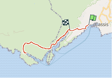
Tocht Stappen van 8,1 km beschikbaar op Provence-Alpes-Côte d'Azur, Bouches-du-Rhône, Cassis. Deze tocht wordt voorgesteld door Michel DUBOIS.
Beschrijving
à faire à la fraîche le matin
Plaatsbepaling
Land:
France
Regio :
Provence-Alpes-Côte d'Azur
Departement/Provincie :
Bouches-du-Rhône
Gemeente :
Cassis
Locatie:
Unknown
Vertrek:(Dec)
Vertrek:(UTM)
705697 ; 4787675 (31T) N.
Opmerkingen