Tocht Mountainbike Pia - Pia -Barcarès -Sainte marie de la Mer -Canet dans les Pyrénées Orientales - Photo

Pia -Barcarès -Sainte marie de la Mer -Canet dans les Pyrénées Orientales

 MarieFrancoise
MarieFrancoise

Gebruiker

© OpenStreetMap contributors
Lengte
Lengte
42 km
Max. hoogte
Max. hoogte
31 m
Positief hoogteverschil
194 m
Km-Effort
Km-Effort  
45 km
Min. hoogte
Min. hoogte
-2 m
Negatief hoogteverschil
194 m
Boucle
Boucle
Ja
Datum van aanmaak :
2022-06-06 07:08:58.16
Laatste wijziging :
2022-06-11 14:48:36.139

(0 Bericht)

Mountainbike
Mountainbike
3h10
Moeilijkheid : Gemakkelijk

Scan deze QR-code om de tocht te openen in de SityTrail-applicatie

Gratisgps-wandelapplicatie

Logo SityTrail SityTrail

IGN / Geografische instituten

SityTrail uit de App Store downloaden SityTrail uit Google Play downloaden

Logo SityTrail SityTrail World

De wereld gaat voor u open

SityTrail uit de App Store downloaden SityTrail uit Google Play downloaden SityTrail op Huawei AppGallery downloaden

Over ons

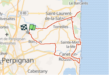
Tocht Mountainbike van 42 km beschikbaar op Occitanië, Pyrénées-Orientales, Pia. Deze tocht wordt voorgesteld door MarieFrancoise.

Beschrijving

très jolie boucle sans aucune difficulté au départ du parking de Pia. chemins et pistes en bon état
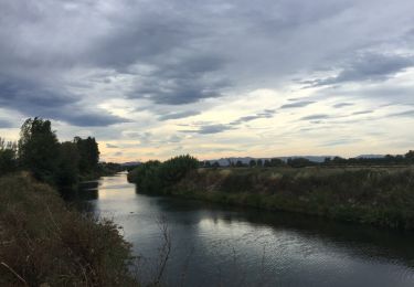
la 1ére partie se fait majoritairement en suivant l Agly jusqu à son embouchure au Barcarès
ensuite direction Sainte Marie puis continuer vers Canet Plage retour par Bompas
a signaler quelques très petits morceaux sur la route

Hoogteprofiel

Foto's

Plaatsbepaling

Land:
France
Regio :
Occitanië
Departement/Provincie :
Pyrénées-Orientales
Gemeente :
Pia
Locatie:
Unknown
Vertrek:(UTM)
493456 ; 4732259 (31T) N.

Wandeltochten in de omgeving

Tocht Stappen Bompas - 66 BOMPAS - promenade en SALANQUE entre Bassas et Agullas - Photo
Stappen
jeff66

Stappen

Gemakkelijk
(1)
Bompas, Occitanië, Pyrénées-Orientales, France
11,1 km | 11,6 km-effort
2h 36min
Ja
Tocht Stappen Perpignan - Perpignan 01.10.2017  - Photo
Stappen
jeff66

Stappen

Gemakkelijk
(1)
Perpignan, Occitanië, Pyrénées-Orientales, France
6,7 km | 7,5 km-effort
1h 39min
Neen
Tocht Stappen Rivesaltes - 66 RIVESALTES promenade dans la cite, la vieille ville et rives d'Agly - Photo
Stappen
jeff66

Stappen

Gemakkelijk
Rivesaltes, Occitanië, Pyrénées-Orientales, France
5,2 km | 5,6 km-effort
1h 5min
Ja
Tocht Stappen Bompas - 66 BOMPAS - itinéraire partagé piétions cycliste en bord de Tet, berge Têt, Bas Vernet, retour par les canaux et centre ville de BOMPAS  - Photo
Stappen
jeff66

Stappen

Medium
Bompas, Occitanië, Pyrénées-Orientales, France
13,4 km | 14,2 km-effort
2h 23min
Ja
Tocht Stappen Perpignan - 66 PERPIGNAN - clos Banet au Bas Vernet, retour par piste cyclable et BOMPAS, puis château Roussillon  - Photo
Stappen
jeff66

Stappen

Medium
Perpignan, Occitanië, Pyrénées-Orientales, France
17 km | 18,4 km-effort
2h 49min
Ja
Tocht Stappen Perpignan - 66 PERPIGNAN polygone nord au Haut Vernet - Photo
Stappen
jeff66

Stappen

Medium
Perpignan, Occitanië, Pyrénées-Orientales, France
10,4 km | 11 km-effort
1h 57min
Ja
Tocht Stappen Saint-Estève - 66 SAINT-ESTEVE, chemin du sacré cœur Perpignan - Photo
Stappen
jeff66

Stappen

Gemakkelijk
Saint-Estève, Occitanië, Pyrénées-Orientales, France
5,6 km | 5,9 km-effort
1h 0min
Neen
Tocht Stappen Rivesaltes - 66 RIVESALTES - promenade le long de l'Agly - Photo
Stappen
jeff66

Stappen

Heel gemakkelijk
Rivesaltes, Occitanië, Pyrénées-Orientales, France
4,3 km | 4,6 km-effort
44min
Ja
Tocht Stappen Pia - 66 PIA - promenade en SALANQUE entre Basse, Llabanère et Agly - Photo
Stappen
jeff66

Stappen

Medium
Pia, Occitanië, Pyrénées-Orientales, France
12,5 km | 13,1 km-effort
1h 59min
Ja


Sluiten
Mijn abonnementen