![](/images/other/stat-length.png)
![Tocht Stappen Caillouet-Orgeville - 2023_05_Caillouet Sud Le Plessis - Photo](https://media.geolcdn.com/t/1900/400/ext.pjpeg?maxdim=2&url=https%3A%2F%2Fstatic1.geolcdn.com%2Fsiteimages%2Fupload%2Ffiles%2F1553511878bg_sport_marche.png)
2023_05_Caillouet Sud Le Plessis
jeanlucien
Gebruiker
![Lengte](/images/other/stat-length.png)
Lengte
13,1 km
![Max. hoogte](https://static1.geolcdn.com/siteimages/upload/files/1508320355ic_sort_altitude_max_24dp.png)
Max. hoogte
135 m
![Positief hoogteverschil](https://static1.geolcdn.com/siteimages/upload/files/1508320355ic_sort_den_pos_24dp.png)
Positief hoogteverschil
163 m
![Km-Effort](/images/other/stat-length.png)
Km-Effort
15,3 km
![Min. hoogte](https://static1.geolcdn.com/siteimages/upload/files/1508320355ic_sort_altitude_min_24dp.png)
Min. hoogte
73 m
![Negatief hoogteverschil](https://static1.geolcdn.com/siteimages/upload/files/1508320355ic_sort_den_neg_24dp.png)
Negatief hoogteverschil
163 m
![Boucle](https://static1.geolcdn.com/siteimages/upload/files/16400158638029165_repeat_loop_refresh_sync_direction_icon.png)
Boucle
Ja
Datum van aanmaak :
2023-06-01 13:04:18.187
Laatste wijziging :
2023-06-01 13:07:11.005
![Stappen](https://static1.geolcdn.com/sitytour/trail-icons/101.png)
2h45
Moeilijkheid : Medium
![Scan deze QR-code om de tocht te openen in de SityTrail-applicatie](https://capi.geolives.com/qq0zvz2zws4bq2lad0pu/sitytour/trails/3683397/qr.png?size=200)
Gratisgps-wandelapplicatie
Over ons
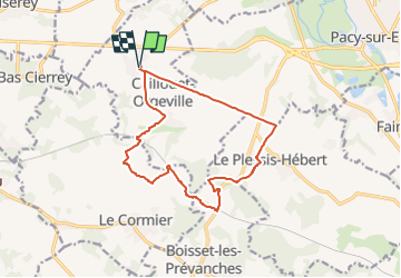
Tocht Stappen van 13,1 km beschikbaar op Normandië, Eure, Caillouet-Orgeville. Deze tocht wordt voorgesteld door jeanlucien.
Beschrijving
Attention portion de la D141 après pont au-dessus de la voie ferrée, praticable sans risque sur le bas-côté (l argeur environ un mètre)
Plaatsbepaling
Land:
France
Regio :
Normandië
Departement/Provincie :
Eure
Gemeente :
Caillouet-Orgeville
Locatie:
Unknown
Vertrek:(Dec)
Vertrek:(UTM)
376291 ; 5429720 (31U) N.
Opmerkingen
Wandeltochten in de omgeving
![Tocht Stappen Ménilles - Ménilles - sentier de découverte - Photo](https://media.geolcdn.com/t/375/260/ext.jpg?maxdim=2&url=https%3A%2F%2Fstatic1.geolcdn.com%2Fsiteimages%2Fupload%2Ffiles%2F1553511878bg_sport_marche.png)
![Stappen Stappen](https://static1.geolcdn.com/sitytour/trail-icons/101.png)
Ménilles - sentier de découverte
Stappen
Gemakkelijk
(2)
Ménilles,
Normandië,
Eure,
France
![](/images/other/stat-length.png)
10,2 km | 12,6 km-effort
2h 41min
![](https://static1.geolcdn.com/siteimages/upload/files/16400158638029165_repeat_loop_refresh_sync_direction_icon.png)
Ja
![Tocht Stappen Le Cormier - Le Cormier - Photo](https://media.geolcdn.com/t/375/260/ext.jpg?maxdim=2&url=https%3A%2F%2Fservices.sitytrail.com%2FGeolivesWS%2FDownloadMedia.ashx%3FTrailID%3D500327%26Media%3Dfix__20151206151811.jpg)
![Stappen Stappen](https://static1.geolcdn.com/sitytour/trail-icons/101.png)
Le Cormier
Stappen
Gemakkelijk
(1)
Le Cormier,
Normandië,
Eure,
France
![](/images/other/stat-length.png)
8,8 km | 10,1 km-effort
2h 1min
![](https://static1.geolcdn.com/siteimages/upload/files/16400158638029165_repeat_loop_refresh_sync_direction_icon.png)
Ja
![Tocht Stappen Miserey - jean pierre chorte - Photo](https://media.geolcdn.com/t/375/260/ext.jpg?maxdim=2&url=https%3A%2F%2Fstatic1.geolcdn.com%2Fsiteimages%2Fupload%2Ffiles%2F1553511878bg_sport_marche.png)
![Stappen Stappen](https://static1.geolcdn.com/sitytour/trail-icons/101.png)
jean pierre chorte
Stappen
Gemakkelijk
Miserey,
Normandië,
Eure,
France
![](/images/other/stat-length.png)
9,3 km | 10,3 km-effort
2h 16min
![](https://static1.geolcdn.com/siteimages/upload/files/16400158638029165_repeat_loop_refresh_sync_direction_icon.png)
Ja
![Tocht Stappen Miserey - les pommiers plus - Photo](https://media.geolcdn.com/t/375/260/ext.jpg?maxdim=2&url=https%3A%2F%2Fstatic1.geolcdn.com%2Fsiteimages%2Fupload%2Ffiles%2F1553511878bg_sport_marche.png)
![Stappen Stappen](https://static1.geolcdn.com/sitytour/trail-icons/101.png)
les pommiers plus
Stappen
Gemakkelijk
Miserey,
Normandië,
Eure,
France
![](/images/other/stat-length.png)
9,6 km | 11 km-effort
2h 17min
![](https://static1.geolcdn.com/siteimages/upload/files/16400158638029165_repeat_loop_refresh_sync_direction_icon.png)
Ja
![Tocht Wegfiets Vaux-sur-Eure - Jouy / Eure - Photo](https://media.geolcdn.com/t/375/260/ext.jpg?maxdim=2&url=https%3A%2F%2Fmedia.geolcdn.com%2Ff%2F91175000-60dc-4c7b-b959-cbd97e105178.jpg)
![Wegfiets Wegfiets](https://static1.geolcdn.com/sitytour/trail-icons/201.png)
Jouy / Eure
Wegfiets
Heel gemakkelijk
Vaux-sur-Eure,
Normandië,
Eure,
France
![](/images/other/stat-length.png)
38 km | 42 km-effort
2h 40min
![](https://static1.geolcdn.com/siteimages/upload/files/16400158638029165_repeat_loop_refresh_sync_direction_icon.png)
Neen
![Tocht Stappen Boisset-les-Prévanches - Boisset les Prévanches 2021 05 13_ - Photo](https://media.geolcdn.com/t/375/260/ext.jpg?maxdim=2&url=https%3A%2F%2Fstatic1.geolcdn.com%2Fsiteimages%2Fupload%2Ffiles%2F1553511878bg_sport_marche.png)
![Stappen Stappen](https://static1.geolcdn.com/sitytour/trail-icons/101.png)
Boisset les Prévanches 2021 05 13_
Stappen
Medium
Boisset-les-Prévanches,
Normandië,
Eure,
France
![](/images/other/stat-length.png)
20 km | 24 km-effort
5h 1min
![](https://static1.geolcdn.com/siteimages/upload/files/16400158638029165_repeat_loop_refresh_sync_direction_icon.png)
Ja
![Tocht Wegfiets Pacy-sur-Eure - La vallée de l’Eure - Photo](https://media.geolcdn.com/t/375/260/ext.jpg?maxdim=2&url=https%3A%2F%2Fmedia.geolcdn.com%2Ff%2F0adca195-af38-41b0-a628-a6ca0589082c.jpg)
![Wegfiets Wegfiets](https://static1.geolcdn.com/sitytour/trail-icons/201.png)
La vallée de l’Eure
Wegfiets
Gemakkelijk
Pacy-sur-Eure,
Normandië,
Eure,
France
![](/images/other/stat-length.png)
45 km | 50 km-effort
2h 11min
![](https://static1.geolcdn.com/siteimages/upload/files/16400158638029165_repeat_loop_refresh_sync_direction_icon.png)
Ja
![Tocht Stappen Boisset-les-Prévanches - Boisset station - Photo](https://media.geolcdn.com/t/375/260/ext.jpg?maxdim=2&url=https%3A%2F%2Fstatic1.geolcdn.com%2Fsiteimages%2Fupload%2Ffiles%2F1553511878bg_sport_marche.png)
![Stappen Stappen](https://static1.geolcdn.com/sitytour/trail-icons/101.png)
Boisset station
Stappen
Gemakkelijk
Boisset-les-Prévanches,
Normandië,
Eure,
France
![](/images/other/stat-length.png)
9,6 km | 11,5 km-effort
2h 6min
![](https://static1.geolcdn.com/siteimages/upload/files/16400158638029165_repeat_loop_refresh_sync_direction_icon.png)
Ja
![Tocht Stappen Le Plessis-Hébert - Le Plessis-hébert (SudOuest)_13.2Km - Photo](https://media.geolcdn.com/t/375/260/ext.jpg?maxdim=2&url=https%3A%2F%2Fstatic1.geolcdn.com%2Fsiteimages%2Fupload%2Ffiles%2F1553511878bg_sport_marche.png)
![Stappen Stappen](https://static1.geolcdn.com/sitytour/trail-icons/101.png)
Le Plessis-hébert (SudOuest)_13.2Km
Stappen
Medium
Le Plessis-Hébert,
Normandië,
Eure,
France
![](/images/other/stat-length.png)
13 km | 15,5 km-effort
3h 25min
![](https://static1.geolcdn.com/siteimages/upload/files/16400158638029165_repeat_loop_refresh_sync_direction_icon.png)
Ja