Tocht Stappen Sainte-Ode - Beauplateau Ste Ode 240823 - Photo

Beauplateau Ste Ode 240823

 guyernage25
guyernage25

Gebruiker

© OpenStreetMap contributors
Lengte
Lengte
15,2 km
Max. hoogte
Max. hoogte
501 m
Positief hoogteverschil
219 m
Km-Effort
Km-Effort  
18,2 km
Min. hoogte
Min. hoogte
369 m
Negatief hoogteverschil
223 m
Boucle
Boucle
Ja
Datum van aanmaak :
2023-08-24 07:20:00.934
Laatste wijziging :
2023-08-27 21:18:26.087

(0 Bericht)

Stappen
Stappen
3h33
Moeilijkheid : Gemakkelijk

Scan deze QR-code om de tocht te openen in de SityTrail-applicatie

Gratisgps-wandelapplicatie

Logo SityTrail SityTrail

IGN / Geografische instituten

SityTrail uit de App Store downloaden SityTrail uit Google Play downloaden

Logo SityTrail SityTrail World

De wereld gaat voor u open

SityTrail uit de App Store downloaden SityTrail uit Google Play downloaden SityTrail op Huawei AppGallery downloaden

Over ons

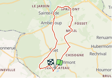
Tocht Stappen van 15,2 km beschikbaar op Wallonië, Luxemburg, Sainte-Ode. Deze tocht wordt voorgesteld door guyernage25.

Beschrijving

Belle rando sur les "beaux plateaux" de Ste Ode

Hoogteprofiel

Foto's

Plaatsbepaling

Land:
Belgium
Regio :
Wallonië
Departement/Provincie :
Luxemburg
Gemeente :
Sainte-Ode
Locatie:
Unknown
Vertrek:(UTM)
681421 ; 5541286 (31U) N.

Wandeltochten in de omgeving

Tocht Te voet Libramont-Chevigny - Remagne étang gpx - Photo
Te voet
GUIDE+

Te voet

Gemakkelijk
(1)
Libramont-Chevigny, Wallonië, Luxemburg, Belgium
7,5 km | 9,5 km-effort
2h 9min
Ja
Tocht Stappen Sainte-Ode - RB-LUX-08 - Raccourci - De part et d’autre de l’Ourthe occidentale - Photo
Stappen
PRO

Stappen

Moeilijk
(2)
Sainte-Ode, Wallonië, Luxemburg, Belgium
15,2 km | 18,6 km-effort
4h 13min
Ja
Tocht Stappen Sainte-Ode - Wandeling van Tonny - Photo
Stappen
GUIDE+

Stappen

Medium
(3)
Sainte-Ode, Wallonië, Luxemburg, Belgium
9,5 km | 12,2 km-effort
2h 36min
Ja
Tocht Stappen Sainte-Ode - Beauplateau - Wandeling
Stappen
GUIDE+

Stappen

Medium
(2)
Sainte-Ode, Wallonië, Luxemburg, Belgium
5,5 km | 6,9 km-effort
1h 29min
Ja
Tocht Stappen Sainte-Ode - Amberloup, Natura 2000 - Des sites qui valent le détour. Lx11 - Photo
Stappen
GUIDE+

Stappen

Gemakkelijk
(4)
Sainte-Ode, Wallonië, Luxemburg, Belgium
4,2 km | 5 km-effort
1h 6min
Ja
Tocht Stappen Sainte-Ode - RB-LUX-08 - De part et d’autre de l’Ourthe occidentale - Photo
Stappen
PRO

Stappen

Medium
(1)
Sainte-Ode, Wallonië, Luxemburg, Belgium
23 km | 29 km-effort
6h 14min
Ja
Tocht Stappen Sainte-Ode - Beauplateau - Le sentier du Coprin (GTA 4) - Photo
Stappen
GUIDE+

Stappen

Zeer moeilijk
(2)
Sainte-Ode, Wallonië, Luxemburg, Belgium
16,6 km | 20 km-effort
4h 20min
Ja
Tocht Stappen Sainte-Ode - Tonny - Promenade de bois Cousin (A7) - Photo
Stappen
GUIDE+

Stappen

Medium
(2)
Sainte-Ode, Wallonië, Luxemburg, Belgium
5,8 km | 7,9 km-effort
1h 40min
Ja
Tocht Stappen Sainte-Ode - Sainte-Ode  Wandeling van de hagen van Magery - Photo
Stappen
GUIDE+

Stappen

Medium
(3)
Sainte-Ode, Wallonië, Luxemburg, Belgium
9,3 km | 11,4 km-effort
2h 29min
Ja


Sluiten
Mijn abonnementen