![](/images/other/stat-length.png)
![Tocht Stappen Gaillères - Etangs de Gaillères - Photo](https://media.geolcdn.com/t/1900/400/ext.pjpeg?maxdim=2&url=https%3A%2F%2Fstatic1.geolcdn.com%2Fsiteimages%2Fupload%2Ffiles%2F1553511878bg_sport_marche.png)
Etangs de Gaillères
DuMarsan
Gebruiker
![Lengte](/images/other/stat-length.png)
Lengte
6,9 km
![Max. hoogte](https://static1.geolcdn.com/siteimages/upload/files/1508320355ic_sort_altitude_max_24dp.png)
Max. hoogte
108 m
![Positief hoogteverschil](https://static1.geolcdn.com/siteimages/upload/files/1508320355ic_sort_den_pos_24dp.png)
Positief hoogteverschil
70 m
![Km-Effort](/images/other/stat-length.png)
Km-Effort
7,9 km
![Min. hoogte](https://static1.geolcdn.com/siteimages/upload/files/1508320355ic_sort_altitude_min_24dp.png)
Min. hoogte
74 m
![Negatief hoogteverschil](https://static1.geolcdn.com/siteimages/upload/files/1508320355ic_sort_den_neg_24dp.png)
Negatief hoogteverschil
72 m
![Boucle](https://static1.geolcdn.com/siteimages/upload/files/16400158638029165_repeat_loop_refresh_sync_direction_icon.png)
Boucle
Ja
Datum van aanmaak :
2015-02-13 00:00:00.0
Laatste wijziging :
2015-02-13 00:00:00.0
![Stappen](https://static1.geolcdn.com/sitytour/trail-icons/101.png)
1h23
Moeilijkheid : Onbekend
![Scan deze QR-code om de tocht te openen in de SityTrail-applicatie](https://capi.geolives.com/qq0zvz2zws4bq2lad0pu/sitytour/trails/382566/qr.png?size=200)
Gratisgps-wandelapplicatie
Over ons
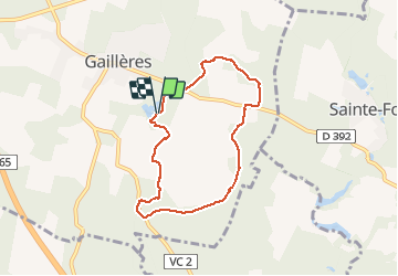
Tocht Stappen van 6,9 km beschikbaar op Nieuw-Aquitanië, Landes, Gaillères. Deze tocht wordt voorgesteld door DuMarsan.
Beschrijving
Rando Familiale très facile assez courte ( 6.9 kms ).
La partie ouest du parcours est intéressant = succession d' étangs enzone boisée sur chemin bien tracé et bien balisé.
Plaatsbepaling
Land:
France
Regio :
Nieuw-Aquitanië
Departement/Provincie :
Landes
Gemeente :
Gaillères
Locatie:
Unknown
Vertrek:(Dec)
Vertrek:(UTM)
711465 ; 4868081 (30T) N.
Opmerkingen
Wandeltochten in de omgeving
![Tocht Stappen Gaillères - Gaillères 2020 - Photo](https://media.geolcdn.com/t/375/260/ext.jpg?maxdim=2&url=https%3A%2F%2Fstatic1.geolcdn.com%2Fsiteimages%2Fupload%2Ffiles%2F1553511878bg_sport_marche.png)
![Stappen Stappen](https://static1.geolcdn.com/sitytour/trail-icons/101.png)
Gaillères 2020
Stappen
Heel gemakkelijk
(1)
Gaillères,
Nieuw-Aquitanië,
Landes,
France
![](/images/other/stat-length.png)
7,2 km | 8,1 km-effort
1h 44min
![](https://static1.geolcdn.com/siteimages/upload/files/16400158638029165_repeat_loop_refresh_sync_direction_icon.png)
Ja
![Tocht Te voet Villeneuve-de-Marsan - Petite Randonnée Villeneuve - Photo](https://media.geolcdn.com/t/375/260/ext.jpg?maxdim=2&url=https%3A%2F%2Fmedia.geolcdn.com%2Ff%2F9a1502fb-95da-4a41-b70c-7efd1ad3de51.jpeg)
![Te voet Te voet](https://static1.geolcdn.com/sitytour/trail-icons/100.png)
Petite Randonnée Villeneuve
Te voet
Gemakkelijk
Villeneuve-de-Marsan,
Nieuw-Aquitanië,
Landes,
France
![](/images/other/stat-length.png)
6,1 km | 7,1 km-effort
1h 36min
![](https://static1.geolcdn.com/siteimages/upload/files/16400158638029165_repeat_loop_refresh_sync_direction_icon.png)
Ja
![Tocht Stappen Gaillères - Gaillères 2022 - Photo](https://media.geolcdn.com/t/375/260/ext.jpg?maxdim=2&url=https%3A%2F%2Fstatic1.geolcdn.com%2Fsiteimages%2Fupload%2Ffiles%2F1553511878bg_sport_marche.png)
![Stappen Stappen](https://static1.geolcdn.com/sitytour/trail-icons/101.png)
Gaillères 2022
Stappen
Heel gemakkelijk
(1)
Gaillères,
Nieuw-Aquitanië,
Landes,
France
![](/images/other/stat-length.png)
7,1 km | 8 km-effort
1h 43min
![](https://static1.geolcdn.com/siteimages/upload/files/16400158638029165_repeat_loop_refresh_sync_direction_icon.png)
Ja
![Tocht Elektrische fiets Gaillères - 011 Gaillères to Aire sur l'Adour - Photo](https://media.geolcdn.com/t/375/260/ext.jpg?maxdim=2&url=https%3A%2F%2Fstatic1.geolcdn.com%2Fsiteimages%2Fupload%2Ffiles%2F1524743154velo.jpg)
![Elektrische fiets Elektrische fiets](https://static1.geolcdn.com/sitytour/trail-icons/205.png)
011 Gaillères to Aire sur l'Adour
Elektrische fiets
Heel gemakkelijk
Gaillères,
Nieuw-Aquitanië,
Landes,
France
![](/images/other/stat-length.png)
50 km | 57 km-effort
Onbekend
![](https://static1.geolcdn.com/siteimages/upload/files/16400158638029165_repeat_loop_refresh_sync_direction_icon.png)
Neen
![Tocht Stappen Villeneuve-de-Marsan - Villeneuve, le midou. trace faite - Photo](https://media.geolcdn.com/t/375/260/ext.jpg?maxdim=2&url=https%3A%2F%2Fstatic1.geolcdn.com%2Fsiteimages%2Fupload%2Ffiles%2F1553511878bg_sport_marche.png)
![Stappen Stappen](https://static1.geolcdn.com/sitytour/trail-icons/101.png)
Villeneuve, le midou. trace faite
Stappen
Gemakkelijk
Villeneuve-de-Marsan,
Nieuw-Aquitanië,
Landes,
France
![](/images/other/stat-length.png)
7,6 km | 8,7 km-effort
1h 34min
![](https://static1.geolcdn.com/siteimages/upload/files/16400158638029165_repeat_loop_refresh_sync_direction_icon.png)
Ja
![Tocht Stappen Pouydesseaux - Pouydesseaux - Photo](https://media.geolcdn.com/t/375/260/ext.jpg?maxdim=2&url=https%3A%2F%2Fstatic1.geolcdn.com%2Fsiteimages%2Fupload%2Ffiles%2F1553511878bg_sport_marche.png)
![Stappen Stappen](https://static1.geolcdn.com/sitytour/trail-icons/101.png)
Pouydesseaux
Stappen
Gemakkelijk
Pouydesseaux,
Nieuw-Aquitanië,
Landes,
France
![](/images/other/stat-length.png)
12,3 km | 13,6 km-effort
3h 0min
![](https://static1.geolcdn.com/siteimages/upload/files/16400158638029165_repeat_loop_refresh_sync_direction_icon.png)
Ja
![Tocht Stappen Gaillères - Circuit des Airials Gaillères - Photo](https://media.geolcdn.com/t/375/260/ext.jpg?maxdim=2&url=https%3A%2F%2Fstatic1.geolcdn.com%2Fsiteimages%2Fupload%2Ffiles%2F1553511878bg_sport_marche.png)
![Stappen Stappen](https://static1.geolcdn.com/sitytour/trail-icons/101.png)
Circuit des Airials Gaillères
Stappen
Heel gemakkelijk
Gaillères,
Nieuw-Aquitanië,
Landes,
France
![](/images/other/stat-length.png)
6,5 km | 7,4 km-effort
2h 17min
![](https://static1.geolcdn.com/siteimages/upload/files/16400158638029165_repeat_loop_refresh_sync_direction_icon.png)
Ja
![Tocht Lopen Pouydesseaux - CO étang mouliot - Photo](https://media.geolcdn.com/t/375/260/ext.jpg?maxdim=2&url=https%3A%2F%2Fstatic1.geolcdn.com%2Fsiteimages%2Fupload%2Ffiles%2F1524743154running.jpg)
![Lopen Lopen](https://static1.geolcdn.com/sitytour/trail-icons/103.png)
CO étang mouliot
Lopen
Moeilijk
Pouydesseaux,
Nieuw-Aquitanië,
Landes,
France
![](/images/other/stat-length.png)
9,7 km | 10,8 km-effort
3h 12min
![](https://static1.geolcdn.com/siteimages/upload/files/16400158638029165_repeat_loop_refresh_sync_direction_icon.png)
Ja
![Tocht Stappen Mazerolles - baussiet - Photo](https://media.geolcdn.com/t/375/260/ext.jpg?maxdim=2&url=https%3A%2F%2Fstatic1.geolcdn.com%2Fsiteimages%2Fupload%2Ffiles%2F1553511878bg_sport_marche.png)
![Stappen Stappen](https://static1.geolcdn.com/sitytour/trail-icons/101.png)
baussiet
Stappen
Medium
Mazerolles,
Nieuw-Aquitanië,
Landes,
France
![](/images/other/stat-length.png)
6,8 km | 7,8 km-effort
2h 24min
![](https://static1.geolcdn.com/siteimages/upload/files/16400158638029165_repeat_loop_refresh_sync_direction_icon.png)
Ja