


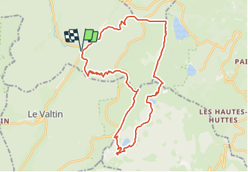
Plainfaing 19 350m +985m

DanielROLLET
Gebruiker


7h40
Moeilijkheid : Moeilijk

Gratisgps-wandelapplicatie
 SityTrail
IGN / Geografische instituten
SityTrail Plus
De wereld gaat voor u open
Over ons
Tocht Stappen van 19,3 km beschikbaar op Grand Est, Vogezen, Plainfaing. Deze tocht wordt voorgesteld door DanielROLLET.
Beschrijving
2023 10 10 - Avec Marie - 10h05 à 17h45
Départ/retour parking Etang des Dames
Beau temps
En arrivant au Lac Vert, nous avons préféré descendre sur la route
Pause 13h30 à 14h00 au Lac de Forlet (avec un vent trés froid!)
Belle balade
Partis un peu tard de Nancy...
Plaatsbepaling
Opmerkingen