![](/images/other/stat-length.png)
![Tour Mountainbike Sénoville - Senoville - Cap Carteret - Photo](https://media.geolcdn.com/t/1900/400/ext.pjpeg?maxdim=2&url=https%3A%2F%2Fservices.sitytrail.com%2FGeolivesWS%2FDownloadMedia.ashx%3FTrailID%3D106916%26Media%3D11678_6.jpg)
Senoville - Cap Carteret
tracegps
Benutzer
![Länge](/images/other/stat-length.png)
Länge
23 km
![Maximale Höhe](https://static1.geolcdn.com/siteimages/upload/files/1508320355ic_sort_altitude_max_24dp.png)
Maximale Höhe
91 m
![Positive Höhendifferenz](https://static1.geolcdn.com/siteimages/upload/files/1508320355ic_sort_den_pos_24dp.png)
Positive Höhendifferenz
312 m
![Km-Effort](/images/other/stat-length.png)
Km-Effort
27 km
![Min. Höhe](https://static1.geolcdn.com/siteimages/upload/files/1508320355ic_sort_altitude_min_24dp.png)
Min. Höhe
10 m
![Negative Höhendifferenz](https://static1.geolcdn.com/siteimages/upload/files/1508320355ic_sort_den_neg_24dp.png)
Negative Höhendifferenz
312 m
![Boucle](https://static1.geolcdn.com/siteimages/upload/files/16400158638029165_repeat_loop_refresh_sync_direction_icon.png)
Boucle
Ja
Erstellungsdatum :
2014-12-10 00:00:00.0
Letzte Änderung :
2014-12-10 00:00:00.0
![Mountainbike](https://static1.geolcdn.com/sitytour/trail-icons/202.png)
2h00
Schwierigkeit : Medium
![Scannen Sie diesen QR-Code, um die Tour in der SityTrail-Anwendung zu öffnen](https://capi.geolives.com/qq0zvz2zws4bq2lad0pu/sitytour/trails/106916/qr.png?size=200)
Kostenlosegpshiking-Anwendung
Über SityTrail
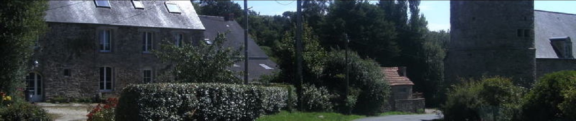
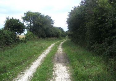
Tour Mountainbike von 23 km verfügbar auf Normandie, Manche, Sénoville. Diese Tour wird von tracegps vorgeschlagen.
Beschreibung
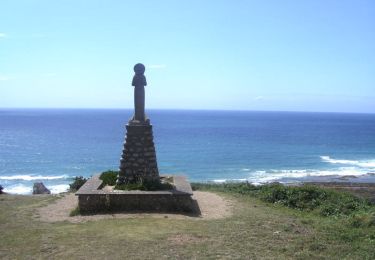
Bonjour à tous, Dans la série des caps, le cap Cateret n'est pas mal du tout. Il y a des temps forts avec chemin sablonneux à parcourir à pied, bonnes montées et belles vues, tout y est pour une bonne rando. Bonne balade.
Ort
Land:
France
Region :
Normandie
Abteilung/Provinz :
Manche
Kommune :
Sénoville
Standort:
Unknown
Gehen Sie:(Dec)
Gehen Sie:(UTM)
590102 ; 5476383 (30U) N.
Kommentare
Touren in der Umgebung
![Tour Mountainbike Sénoville - Tour de Senoville en VTT - Photo](https://media.geolcdn.com/t/375/260/ext.jpg?maxdim=2&url=https%3A%2F%2Fservices.sitytrail.com%2FGeolivesWS%2FDownloadMedia.ashx%3FTrailID%3D106917%26Media%3D11679_6.jpg)
![Mountainbike Mountainbike](https://static1.geolcdn.com/sitytour/trail-icons/202.png)
Tour de Senoville en VTT
Mountainbike
Einfach
Sénoville,
Normandie,
Manche,
France
![](/images/other/stat-length.png)
11,3 km | 13,1 km-effort
1h 0min
![](https://static1.geolcdn.com/siteimages/upload/files/16400158638029165_repeat_loop_refresh_sync_direction_icon.png)
Ja
![Tour Mountainbike Sénoville - Senoville - Cap Rozel - Photo](https://media.geolcdn.com/t/375/260/ext.jpg?maxdim=2&url=https%3A%2F%2Fservices.sitytrail.com%2FGeolivesWS%2FDownloadMedia.ashx%3FTrailID%3D106914%26Media%3D11675_6.jpg)
![Mountainbike Mountainbike](https://static1.geolcdn.com/sitytour/trail-icons/202.png)
Senoville - Cap Rozel
Mountainbike
Schwierig
Sénoville,
Normandie,
Manche,
France
![](/images/other/stat-length.png)
27 km | 31 km-effort
2h 49min
![](https://static1.geolcdn.com/siteimages/upload/files/16400158638029165_repeat_loop_refresh_sync_direction_icon.png)
Ja
![Tour Mountainbike Pierreville - Le Tour de Nathan - Pierreville - Photo](https://media.geolcdn.com/t/375/260/ext.jpg?maxdim=2&url=https%3A%2F%2Fservices.sitytrail.com%2FGeolivesWS%2FDownloadMedia.ashx%3FTrailID%3D136867%26Media%3D13534_1.jpg)
![Mountainbike Mountainbike](https://static1.geolcdn.com/sitytour/trail-icons/202.png)
Le Tour de Nathan - Pierreville
Mountainbike
Medium
Pierreville,
Normandie,
Manche,
France
![](/images/other/stat-length.png)
28 km | 34 km-effort
2h 0min
![](https://static1.geolcdn.com/siteimages/upload/files/16400158638029165_repeat_loop_refresh_sync_direction_icon.png)
Ja
![Tour Wandern Surtainville - surtainville grande - Photo](https://media.geolcdn.com/t/375/260/ext.jpg?maxdim=2&url=https%3A%2F%2Fstatic1.geolcdn.com%2Fsiteimages%2Fupload%2Ffiles%2F1553511878bg_sport_marche.png)
![Wandern Wandern](https://static1.geolcdn.com/sitytour/trail-icons/101.png)
surtainville grande
Wandern
Schwierig
Surtainville,
Normandie,
Manche,
France
![](/images/other/stat-length.png)
14,4 km | 16,2 km-effort
2h 47min
![](https://static1.geolcdn.com/siteimages/upload/files/16400158638029165_repeat_loop_refresh_sync_direction_icon.png)
Nein
![Tour Wandern Bricquebec-en-Cotentin - Le Vretot - Photo](https://media.geolcdn.com/t/375/260/ext.jpg?maxdim=2&url=https%3A%2F%2Fstatic1.geolcdn.com%2Fsiteimages%2Fupload%2Ffiles%2F1553511878bg_sport_marche.png)
![Wandern Wandern](https://static1.geolcdn.com/sitytour/trail-icons/101.png)
Le Vretot
Wandern
Schwierig
Bricquebec-en-Cotentin,
Normandie,
Manche,
France
![](/images/other/stat-length.png)
12,2 km | 15,4 km-effort
2h 54min
![](https://static1.geolcdn.com/siteimages/upload/files/16400158638029165_repeat_loop_refresh_sync_direction_icon.png)
Ja
![Tour Motorrad Sénoville - 29 décembre 2020 - Photo](https://media.geolcdn.com/t/375/260/ext.jpg?maxdim=2&url=https%3A%2F%2Fstatic1.geolcdn.com%2Fsiteimages%2Fupload%2Ffiles%2F1524743155moto.jpg)
![Motorrad Motorrad](https://static1.geolcdn.com/sitytour/trail-icons/402.png)
29 décembre 2020
Motorrad
Sehr leicht
Sénoville,
Normandie,
Manche,
France
![](/images/other/stat-length.png)
101 km | 120 km-effort
10h 26min
![](https://static1.geolcdn.com/siteimages/upload/files/16400158638029165_repeat_loop_refresh_sync_direction_icon.png)
Ja
![Tour Wandern Les Moitiers-d'Allonne - 3 moulins et allée couverte - Photo](https://media.geolcdn.com/t/375/260/ext.jpg?maxdim=2&url=https%3A%2F%2Fstatic1.geolcdn.com%2Fsiteimages%2Fupload%2Ffiles%2F1553511878bg_sport_marche.png)
![Wandern Wandern](https://static1.geolcdn.com/sitytour/trail-icons/101.png)
3 moulins et allée couverte
Wandern
Les Moitiers-d'Allonne,
Normandie,
Manche,
France
![](/images/other/stat-length.png)
11,2 km | 0 m-effort
2h 45min
![](https://static1.geolcdn.com/siteimages/upload/files/16400158638029165_repeat_loop_refresh_sync_direction_icon.png)
Nein
![Tour Mountainbike Bricquebec-en-Cotentin - le vretot - Photo](https://media.geolcdn.com/t/375/260/ext.jpg?maxdim=2&url=https%3A%2F%2Fstatic1.geolcdn.com%2Fsiteimages%2Fupload%2Ffiles%2F1524743154velo.jpg)
![Mountainbike Mountainbike](https://static1.geolcdn.com/sitytour/trail-icons/202.png)
le vretot
Mountainbike
Sehr leicht
Bricquebec-en-Cotentin,
Normandie,
Manche,
France
![](/images/other/stat-length.png)
24 km | 28 km-effort
2h 8min
![](https://static1.geolcdn.com/siteimages/upload/files/16400158638029165_repeat_loop_refresh_sync_direction_icon.png)
Ja
![Tour Wandern Sortosville-en-Beaumont - Sortoville en Beaumont moyenne - Photo](https://media.geolcdn.com/t/375/260/ext.jpg?maxdim=2&url=https%3A%2F%2Fstatic1.geolcdn.com%2Fsiteimages%2Fupload%2Ffiles%2F1553511878bg_sport_marche.png)
![Wandern Wandern](https://static1.geolcdn.com/sitytour/trail-icons/101.png)
Sortoville en Beaumont moyenne
Wandern
Medium
Sortosville-en-Beaumont,
Normandie,
Manche,
France
![](/images/other/stat-length.png)
7,5 km | 9,9 km-effort
2h 23min
![](https://static1.geolcdn.com/siteimages/upload/files/16400158638029165_repeat_loop_refresh_sync_direction_icon.png)
Ja