Tour Zu Fuß Marles-les-Mines - Marles les claires eaux 8km - Photo

Marles les claires eaux 8km

 Blourouce
Blourouce

Benutzer

© OpenStreetMap contributors
Länge
Länge
8,5 km
Maximale Höhe
Maximale Höhe
97 m
Positive Höhendifferenz
99 m
Km-Effort
Km-Effort  
9,8 km
Min. Höhe
Min. Höhe
34 m
Negative Höhendifferenz
94 m
Boucle
Boucle
Ja
Erstellungsdatum :
2019-02-26 10:01:20.839
Letzte Änderung :
2019-02-26 10:18:12.131

(0 Nachricht)

Zu Fuß
Zu Fuß
--
Schwierigkeit : Sehr leicht

Scannen Sie diesen QR-Code, um die Tour in der SityTrail-Anwendung zu öffnen

Kostenlosegpshiking-Anwendung

Logo SityTrail SityTrail

IGN / Geografische Institute

SityTrail aus dem App Store herunterladen SityTrail von Google Play herunterladen

Logo SityTrail SityTrail World

Die Welt öffnet sich für Sie

SityTrail aus dem App Store herunterladen SityTrail von Google Play herunterladen SityTrail auf Huawei AppGallery herunterladen

Über SityTrail

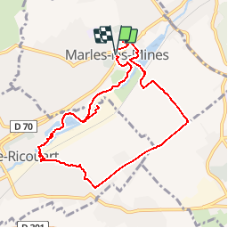
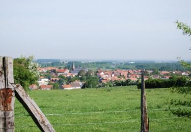
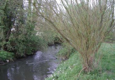
Tour Zu Fuß von 8,5 km verfügbar auf Nordfrankreich, Pas-de-Calais, Marles-les-Mines. Diese Tour wird von Blourouce vorgeschlagen.

Höhenprofil

Ort

Land:
France
Region :
Nordfrankreich
Abteilung/Provinz :
Pas-de-Calais
Kommune :
Marles-les-Mines
Standort:
Unknown
Gehen Sie:(Dec)
Gehen Sie:(UTM)
464962 ; 5594538 (31U) N.

Touren in der Umgebung

Tour Wandern Burbure - Le Moulin à Pano - Burbure - Photo
Wandern
tracegps

Wandern

Medium
(1)
Burbure, Nordfrankreich, Pas-de-Calais, France
13 km | 14,8 km-effort
2h 45min
Ja
Tour Wandern Lapugnoy - Le sentier d'Ecques -  Lapugnoy - Photo
Wandern
tracegps

Wandern

Medium
(3)
Lapugnoy, Nordfrankreich, Pas-de-Calais, France
12,1 km | 14,1 km-effort
3h 0min
Ja
Tour Laufen Houdain - viking  - Photo
Laufen
Viking

Laufen

Sehr leicht
Houdain, Nordfrankreich, Pas-de-Calais, France
6,1 km | 7,3 km-effort
47min
Nein
Tour Wandern Bruay-la-Buissière - Bois des dames - Photo
Wandern
pseudokool

Wandern

Medium
Bruay-la-Buissière, Nordfrankreich, Pas-de-Calais, France
13,7 km | 16,3 km-effort
2h 20min
Ja
Tour Mountainbike Burbure - Scyrendale - Burbure - Photo
Mountainbike
tracegps

Mountainbike

Schwierig
Burbure, Nordfrankreich, Pas-de-Calais, France
11,9 km | 13,9 km-effort
45min
Ja
Tour Wandern Burbure - Scyrendale - Burbure - Photo
Wandern
tracegps

Wandern

Schwierig
Burbure, Nordfrankreich, Pas-de-Calais, France
11,9 km | 13,9 km-effort
3h 0min
Ja
Tour Nordic Walking Haillicourt - Haillicourt reco - Photo
Nordic Walking
ancar

Nordic Walking

Sehr leicht
Haillicourt, Nordfrankreich, Pas-de-Calais, France
7,9 km | 9,8 km-effort
2h 3min
Ja
Tour Wandern Camblain-Châtelain - Camblain-Châtelain - Photo
Wandern
jpblimond

Wandern

Medium
Camblain-Châtelain, Nordfrankreich, Pas-de-Calais, France
19,6 km | 23 km-effort
4h 26min
Ja
Tour Wandern Lapugnoy - SityTrail - Le sentier d'Ecques -  Lapugnoy - Photo
Wandern
Blourouce

Wandern

Schwierig
Lapugnoy, Nordfrankreich, Pas-de-Calais, France
11,9 km | 13,8 km-effort
3h 9min
Ja


Schließen
Meine Abonnements