![](/images/other/stat-length.png)
![Tour Wandern Montreal - Wikiloc - Montreal - Parc Nature du Cap Saint-Jacques -Sentier du Lapin - Rando-Québec - Photo](https://media.geolcdn.com/t/1900/400/ext.pjpeg?maxdim=2&url=https%3A%2F%2Fstatic1.geolcdn.com%2Fsiteimages%2Fupload%2Ffiles%2F1553511878bg_sport_marche.png)
Wikiloc - Montreal - Parc Nature du Cap Saint-Jacques -Sentier du Lapin - Rando-Québec
Alizée.pee
Benutzer GUIDE
![Länge](/images/other/stat-length.png)
Länge
5,9 km
![Maximale Höhe](https://static1.geolcdn.com/siteimages/upload/files/1508320355ic_sort_altitude_max_24dp.png)
Maximale Höhe
39 m
![Positive Höhendifferenz](https://static1.geolcdn.com/siteimages/upload/files/1508320355ic_sort_den_pos_24dp.png)
Positive Höhendifferenz
58 m
![Km-Effort](/images/other/stat-length.png)
Km-Effort
6,6 km
![Min. Höhe](https://static1.geolcdn.com/siteimages/upload/files/1508320355ic_sort_altitude_min_24dp.png)
Min. Höhe
20 m
![Negative Höhendifferenz](https://static1.geolcdn.com/siteimages/upload/files/1508320355ic_sort_den_neg_24dp.png)
Negative Höhendifferenz
56 m
![Boucle](https://static1.geolcdn.com/siteimages/upload/files/16400158638029165_repeat_loop_refresh_sync_direction_icon.png)
Boucle
Ja
Erstellungsdatum :
2019-08-22 12:43:51.381
Letzte Änderung :
2019-08-22 12:47:33.764
![Wandern](https://static1.geolcdn.com/sitytour/trail-icons/101.png)
1h27
Schwierigkeit : Medium
![Scannen Sie diesen QR-Code, um die Tour in der SityTrail-Anwendung zu öffnen](https://capi.geolives.com/qq0zvz2zws4bq2lad0pu/sitytour/trails/2179192/qr.png?size=200)
Kostenlosegpshiking-Anwendung
Über SityTrail
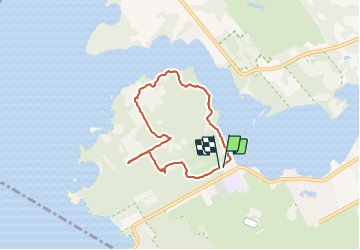
Tour Wandern von 5,9 km verfügbar auf Québec, Agglomération de Montréal, Montreal. Diese Tour wird von Alizée.pee vorgeschlagen.
Beschreibung
Parc ayant la forme d'une immense prequ'île s'avançant dans le lac des Deux Montagnes. Cette randonnée est une porte de sortie vers un monde exotique avec une splendide nature !
Ort
Land:
Canada
Region :
Québec
Abteilung/Provinz :
Agglomération de Montréal
Kommune :
Montreal
Standort:
Unknown
Gehen Sie:(Dec)
Gehen Sie:(UTM)
584385 ; 5034845 (18T) N.
Kommentare
Touren in der Umgebung
![Tour Auto Beaconsfield - Baie d'Urfe - Photo](https://media.geolcdn.com/t/375/260/ext.jpg?maxdim=2&url=https%3A%2F%2Fstatic1.geolcdn.com%2Fsiteimages%2Fupload%2Ffiles%2F15247431544x4.jpg)
![Auto Auto](https://static1.geolcdn.com/sitytour/trail-icons/401.png)
Baie d'Urfe
Auto
Sehr leicht
Beaconsfield,
Québec,
Agglomération de Montréal,
Canada
![](/images/other/stat-length.png)
11,8 km | 12,9 km-effort
27min
![](https://static1.geolcdn.com/siteimages/upload/files/16400158638029165_repeat_loop_refresh_sync_direction_icon.png)
Nein