![](/images/other/stat-length.png)
![Tour Zu Fuß Ledegem - Oosthove - Photo](https://media.geolcdn.com/t/1900/400/ext.pjpeg?maxdim=2&url=https%3A%2F%2Fmedia.geolcdn.com%2Ff%2F066f7295-bb47-4477-8c63-97463508c438.jpeg)
Oosthove
SityTrail - itinéraires balisés pédestres
Tous les sentiers balisés d’Europe PRO
![Länge](/images/other/stat-length.png)
Länge
12,9 km
![Maximale Höhe](https://static1.geolcdn.com/siteimages/upload/files/1508320355ic_sort_altitude_max_24dp.png)
Maximale Höhe
25 m
![Positive Höhendifferenz](https://static1.geolcdn.com/siteimages/upload/files/1508320355ic_sort_den_pos_24dp.png)
Positive Höhendifferenz
54 m
![Km-Effort](/images/other/stat-length.png)
Km-Effort
13,6 km
![Min. Höhe](https://static1.geolcdn.com/siteimages/upload/files/1508320355ic_sort_altitude_min_24dp.png)
Min. Höhe
15 m
![Negative Höhendifferenz](https://static1.geolcdn.com/siteimages/upload/files/1508320355ic_sort_den_neg_24dp.png)
Negative Höhendifferenz
53 m
![Boucle](https://static1.geolcdn.com/siteimages/upload/files/16400158638029165_repeat_loop_refresh_sync_direction_icon.png)
Boucle
Ja
Kennzeichnung
Erstellungsdatum :
2022-02-09 15:32:44.239
Letzte Änderung :
2022-02-09 18:08:58.172
![Zu Fuß](https://static1.geolcdn.com/sitytour/trail-icons/100.png)
3h05
Schwierigkeit : Einfach
![Scannen Sie diesen QR-Code, um die Tour in der SityTrail-Anwendung zu öffnen](https://capi.geolives.com/qq0zvz2zws4bq2lad0pu/sitytour/trails/3083763/qr.png?size=200)
Kostenlosegpshiking-Anwendung
Über SityTrail
Tour Zu Fuß von 12,9 km verfügbar auf Flandern, Westflandern, Ledegem. Diese Tour wird von SityTrail - itinéraires balisés pédestres vorgeschlagen.
Beschreibung
Deze wandelroute neemt je mee in en rond Ledegem.
Ort
Land:
Belgium
Region :
Flandern
Abteilung/Provinz :
Westflandern
Kommune :
Ledegem
Standort:
Rollegem-Kapelle
Gehen Sie:(Dec)
Gehen Sie:(UTM)
510198 ; 5635160 (31U) N.
Kommentare
Touren in der Umgebung
![Tour Zu Fuß Moorslede - Pompeschitters wandelroute - Photo](https://media.geolcdn.com/t/375/260/ext.jpg?maxdim=2&url=https%3A%2F%2Fmedia.geolcdn.com%2Ff%2F41739a4b-4e57-4665-b5a5-a88f301a11f1.jpeg)
![Zu Fuß Zu Fuß](https://static1.geolcdn.com/sitytour/trail-icons/100.png)
Pompeschitters wandelroute
Zu Fuß
Einfach
Moorslede,
Flandern,
Westflandern,
Belgium
![](/images/other/stat-length.png)
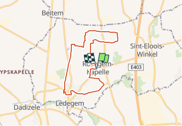
9 km | 9,8 km-effort
2h 13min
![](https://static1.geolcdn.com/siteimages/upload/files/16400158638029165_repeat_loop_refresh_sync_direction_icon.png)
Ja
![Tour Wandern Wevelgem - piste baptiste - Photo](https://media.geolcdn.com/t/375/260/ext.jpg?maxdim=2&url=https%3A%2F%2Fstatic1.geolcdn.com%2Fsiteimages%2Fupload%2Ffiles%2F1553511878bg_sport_marche.png)
![Wandern Wandern](https://static1.geolcdn.com/sitytour/trail-icons/101.png)
piste baptiste
Wandern
Einfach
(1)
Wevelgem,
Flandern,
Westflandern,
Belgium
![](/images/other/stat-length.png)
1,2 km | 1,3 km-effort
18min
![](https://static1.geolcdn.com/siteimages/upload/files/16400158638029165_repeat_loop_refresh_sync_direction_icon.png)
Ja
![Tour Fahrrad Moorslede - f-belgie-bevevaartroute - Photo](https://media.geolcdn.com/t/375/260/ext.jpg?maxdim=2&url=https%3A%2F%2Fstatic1.geolcdn.com%2Fsiteimages%2Fupload%2Ffiles%2F1524743154velo.jpg)
![Fahrrad Fahrrad](https://static1.geolcdn.com/sitytour/trail-icons/200.png)
f-belgie-bevevaartroute
Fahrrad
Sehr leicht
Moorslede,
Flandern,
Westflandern,
Belgium
![](/images/other/stat-length.png)
40 km | 43 km-effort
Unbekannt
![](https://static1.geolcdn.com/siteimages/upload/files/16400158638029165_repeat_loop_refresh_sync_direction_icon.png)
Ja
![Tour Fahrrad Wevelgem - Belgie - Bedevaartroute - Photo](https://media.geolcdn.com/t/375/260/ext.jpg?maxdim=2&url=https%3A%2F%2Fstatic1.geolcdn.com%2Fsiteimages%2Fupload%2Ffiles%2F1524743154velo.jpg)
![Fahrrad Fahrrad](https://static1.geolcdn.com/sitytour/trail-icons/200.png)
Belgie - Bedevaartroute
Fahrrad
Sehr leicht
Wevelgem,
Flandern,
Westflandern,
Belgium
![](/images/other/stat-length.png)
40 km | 43 km-effort
Unbekannt
![](https://static1.geolcdn.com/siteimages/upload/files/16400158638029165_repeat_loop_refresh_sync_direction_icon.png)
Ja
![Tour Wandern Moorslede - w-belgie-pompeschitterswandelpad - Photo](https://media.geolcdn.com/t/375/260/ext.jpg?maxdim=2&url=https%3A%2F%2Fstatic1.geolcdn.com%2Fsiteimages%2Fupload%2Ffiles%2F1553511878bg_sport_marche.png)
![Wandern Wandern](https://static1.geolcdn.com/sitytour/trail-icons/101.png)
w-belgie-pompeschitterswandelpad
Wandern
Sehr leicht
Moorslede,
Flandern,
Westflandern,
Belgium
![](/images/other/stat-length.png)
8,7 km | 9,5 km-effort
Unbekannt
![](https://static1.geolcdn.com/siteimages/upload/files/16400158638029165_repeat_loop_refresh_sync_direction_icon.png)
Ja
![Tour Wandern Moorslede - Dadizele Dadizeelse Kouters - 12 km RT - Photo](https://media.geolcdn.com/t/375/260/ext.jpg?maxdim=2&url=https%3A%2F%2Fstatic1.geolcdn.com%2Fsiteimages%2Fupload%2Ffiles%2F1553511878bg_sport_marche.png)
![Wandern Wandern](https://static1.geolcdn.com/sitytour/trail-icons/101.png)
Dadizele Dadizeelse Kouters - 12 km RT
Wandern
Sehr leicht
Moorslede,
Flandern,
Westflandern,
Belgium
![](/images/other/stat-length.png)
11,8 km | 12,6 km-effort
Unbekannt
![](https://static1.geolcdn.com/siteimages/upload/files/16400158638029165_repeat_loop_refresh_sync_direction_icon.png)
Ja
![Tour Wandern Moorslede - Milpattes - 27052013 - Photo](https://media.geolcdn.com/t/375/260/ext.jpg?maxdim=2&url=https%3A%2F%2Fstatic1.geolcdn.com%2Fsiteimages%2Fupload%2Ffiles%2F1553511878bg_sport_marche.png)
![Wandern Wandern](https://static1.geolcdn.com/sitytour/trail-icons/101.png)
Milpattes - 27052013
Wandern
Einfach
Moorslede,
Flandern,
Westflandern,
Belgium
![](/images/other/stat-length.png)
7,8 km | 8,5 km-effort
1h 52min
![](https://static1.geolcdn.com/siteimages/upload/files/16400158638029165_repeat_loop_refresh_sync_direction_icon.png)
Ja
![Tour Wandern Wevelgem - Moorsele - Photo](https://media.geolcdn.com/t/375/260/ext.jpg?maxdim=2&url=https%3A%2F%2Fstatic1.geolcdn.com%2Fsiteimages%2Fupload%2Ffiles%2F1553511878bg_sport_marche.png)
![Wandern Wandern](https://static1.geolcdn.com/sitytour/trail-icons/101.png)
Moorsele
Wandern
Sehr leicht
Wevelgem,
Flandern,
Westflandern,
Belgium
![](/images/other/stat-length.png)
12,5 km | 13,2 km-effort
Unbekannt
![](https://static1.geolcdn.com/siteimages/upload/files/16400158638029165_repeat_loop_refresh_sync_direction_icon.png)
Ja
![Tour Rennrad Ledegem - cyclo - Photo](https://media.geolcdn.com/t/375/260/ext.jpg?maxdim=2&url=https%3A%2F%2Fstatic1.geolcdn.com%2Fsiteimages%2Fupload%2Ffiles%2F1524743154velo.jpg)
![Rennrad Rennrad](https://static1.geolcdn.com/sitytour/trail-icons/201.png)
cyclo
Rennrad
Sehr schwierig
Ledegem,
Flandern,
Westflandern,
Belgium
![](/images/other/stat-length.png)
60 km | 64 km-effort
3h 1min
![](https://static1.geolcdn.com/siteimages/upload/files/16400158638029165_repeat_loop_refresh_sync_direction_icon.png)
Ja