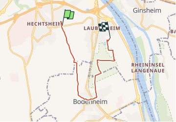
![](/images/other/stat-length.png)
![Tour Zu Fuß Unbekannt - [Grünes Eichenblatt] Mainz (Stadtpark) - Hechtsheim - Bodenheim - Laubenheim - Mainz (Stadtpark) - Photo](https://media.geolcdn.com/t/1900/400/ext.pjpeg?maxdim=2&url=https%3A%2F%2Fstatic1.geolcdn.com%2Fsiteimages%2Fupload%2Ffiles%2F1545311037marcheuse_200dpi.jpg)
[Grünes Eichenblatt] Mainz (Stadtpark) - Hechtsheim - Bodenheim - Laubenheim - Mainz (Stadtpark)
SityTrail - itinéraires balisés pédestres
Tous les sentiers balisés d’Europe PRO
![Länge](/images/other/stat-length.png)
Länge
9,9 km
![Maximale Höhe](https://static1.geolcdn.com/siteimages/upload/files/1508320355ic_sort_altitude_max_24dp.png)
Maximale Höhe
193 m
![Positive Höhendifferenz](https://static1.geolcdn.com/siteimages/upload/files/1508320355ic_sort_den_pos_24dp.png)
Positive Höhendifferenz
63 m
![Km-Effort](/images/other/stat-length.png)
Km-Effort
11 km
![Min. Höhe](https://static1.geolcdn.com/siteimages/upload/files/1508320355ic_sort_altitude_min_24dp.png)
Min. Höhe
78 m
![Negative Höhendifferenz](https://static1.geolcdn.com/siteimages/upload/files/1508320355ic_sort_den_neg_24dp.png)
Negative Höhendifferenz
156 m
![Boucle](https://static1.geolcdn.com/siteimages/upload/files/16400158638029165_repeat_loop_refresh_sync_direction_icon.png)
Boucle
Nein
Kennzeichnung
Erstellungsdatum :
2022-02-11 14:05:45.279
Letzte Änderung :
2022-02-11 14:05:45.279
![Zu Fuß](https://static1.geolcdn.com/sitytour/trail-icons/100.png)
2h30
Schwierigkeit : Einfach
![Scannen Sie diesen QR-Code, um die Tour in der SityTrail-Anwendung zu öffnen](https://capi.geolives.com/qq0zvz2zws4bq2lad0pu/sitytour/trails/3091907/qr.png?size=200)
Kostenlosegpshiking-Anwendung
Über SityTrail
Tour Zu Fuß von 9,9 km verfügbar auf Rheinland-Pfalz, Mainz, Unbekannt. Diese Tour wird von SityTrail - itinéraires balisés pédestres vorgeschlagen.
Beschreibung
Dieser Weg wird in der Realität nicht mehr gewartet. Die Beschilderung verblasst und wird zunehmend lückenhaft.
Symbol: Grünes Eichenblatt auf weißem Grund
Ort
Land:
Germany
Region :
Rheinland-Pfalz
Abteilung/Provinz :
Mainz
Kommune :
Unbekannt
Standort:
Hechtsheim
Gehen Sie:(Dec)
Gehen Sie:(UTM)
448994 ; 5534871 (32U) N.
Kommentare
Touren in der Umgebung
![Tour Zu Fuß Unbekannt - DE-RUW - Photo](https://media.geolcdn.com/t/375/260/ext.jpg?maxdim=2&url=https%3A%2F%2Fmedia.geolcdn.com%2Ff%2Fe13ed02b-76ca-4fcb-b565-e350b978c3e4.jpeg)
![Zu Fuß Zu Fuß](https://static1.geolcdn.com/sitytour/trail-icons/100.png)
![Tour Zu Fuß Unbekannt - Kleiner Mainzer Höhenweg - Photo](https://media.geolcdn.com/t/375/260/ext.jpg?maxdim=2&url=https%3A%2F%2Fmedia.geolcdn.com%2Ff%2Fdde9b2a7-c3ae-4197-bfe0-a9db1ded2ec4.jpeg)
![Zu Fuß Zu Fuß](https://static1.geolcdn.com/sitytour/trail-icons/100.png)
Kleiner Mainzer Höhenweg
Zu Fuß
Schwierig
Unbekannt,
Rheinland-Pfalz,
Mainz,
Germany
![](/images/other/stat-length.png)
31 km | 36 km-effort
8h 15min
![](https://static1.geolcdn.com/siteimages/upload/files/16400158638029165_repeat_loop_refresh_sync_direction_icon.png)
Nein
![Tour Zu Fuß Unbekannt - DE-WZO - Photo](https://media.geolcdn.com/t/375/260/ext.jpg?maxdim=2&url=https%3A%2F%2Fstatic1.geolcdn.com%2Fsiteimages%2Fupload%2Ffiles%2F1545311037marcheuse_200dpi.jpg)
![Zu Fuß Zu Fuß](https://static1.geolcdn.com/sitytour/trail-icons/100.png)
![Tour Zu Fuß Unbekannt - Rondwandeling Mainz Hbf - Photo](https://media.geolcdn.com/t/375/260/ext.jpg?maxdim=2&url=https%3A%2F%2Fstatic1.geolcdn.com%2Fsiteimages%2Fupload%2Ffiles%2F1545311037marcheuse_200dpi.jpg)
![Zu Fuß Zu Fuß](https://static1.geolcdn.com/sitytour/trail-icons/100.png)
Rondwandeling Mainz Hbf
Zu Fuß
Einfach
Unbekannt,
Rheinland-Pfalz,
Mainz,
Germany
![](/images/other/stat-length.png)
12,3 km | 13,6 km-effort
3h 9min
![](https://static1.geolcdn.com/siteimages/upload/files/16400158638029165_repeat_loop_refresh_sync_direction_icon.png)
Ja
![Tour Motorboot Unbekannt - Mainz - Photo](https://media.geolcdn.com/t/375/260/ext.jpg?maxdim=2&url=https%3A%2F%2Fsecurestorage.geolives.com%2Fsitytour%2Ftrail-bg%2Fdefault.jpg)
![Motorboot Motorboot](https://static1.geolcdn.com/sitytour/trail-icons/701.png)
Mainz
Motorboot
Sehr leicht
Unbekannt,
Rheinland-Pfalz,
Mainz,
Germany
![](/images/other/stat-length.png)
7,1 km | 7,6 km-effort
2h 32min
![](https://static1.geolcdn.com/siteimages/upload/files/16400158638029165_repeat_loop_refresh_sync_direction_icon.png)
Nein
![Tour Fahrrad Unbekannt - Eurovélo 6 de Mayence à Coblence - Photo](https://media.geolcdn.com/t/375/260/ext.jpg?maxdim=2&url=https%3A%2F%2Fstatic1.geolcdn.com%2Fsiteimages%2Fupload%2Ffiles%2F1524743154velo.jpg)
![Fahrrad Fahrrad](https://static1.geolcdn.com/sitytour/trail-icons/200.png)
Eurovélo 6 de Mayence à Coblence
Fahrrad
Einfach
Unbekannt,
Rheinland-Pfalz,
Mainz,
Germany
![](/images/other/stat-length.png)
102 km | 112 km-effort
6h 39min
![](https://static1.geolcdn.com/siteimages/upload/files/16400158638029165_repeat_loop_refresh_sync_direction_icon.png)
Nein