![](/images/other/stat-length.png)
![Tour Zu Fuß Blieskastel - Pirminiusweg (kurze Variante) - Photo](https://media.geolcdn.com/t/1900/400/ext.pjpeg?maxdim=2&url=https%3A%2F%2Fstatic1.geolcdn.com%2Fsiteimages%2Fupload%2Ffiles%2F1545311037marcheuse_200dpi.jpg)
Pirminiusweg (kurze Variante)
SityTrail - itinéraires balisés pédestres
Tous les sentiers balisés d’Europe PRO
![Länge](/images/other/stat-length.png)
Länge
3,2 km
![Maximale Höhe](https://static1.geolcdn.com/siteimages/upload/files/1508320355ic_sort_altitude_max_24dp.png)
Maximale Höhe
339 m
![Positive Höhendifferenz](https://static1.geolcdn.com/siteimages/upload/files/1508320355ic_sort_den_pos_24dp.png)
Positive Höhendifferenz
21 m
![Km-Effort](/images/other/stat-length.png)
Km-Effort
3,6 km
![Min. Höhe](https://static1.geolcdn.com/siteimages/upload/files/1508320355ic_sort_altitude_min_24dp.png)
Min. Höhe
291 m
![Negative Höhendifferenz](https://static1.geolcdn.com/siteimages/upload/files/1508320355ic_sort_den_neg_24dp.png)
Negative Höhendifferenz
59 m
![Boucle](https://static1.geolcdn.com/siteimages/upload/files/16400158638029165_repeat_loop_refresh_sync_direction_icon.png)
Boucle
Nein
Kennzeichnung
Erstellungsdatum :
2022-02-11 17:24:06.598
Letzte Änderung :
2022-02-11 17:24:06.598
![Zu Fuß](https://static1.geolcdn.com/sitytour/trail-icons/100.png)
48m
Schwierigkeit : Einfach
![Scannen Sie diesen QR-Code, um die Tour in der SityTrail-Anwendung zu öffnen](https://capi.geolives.com/qq0zvz2zws4bq2lad0pu/sitytour/trails/3097861/qr.png?size=200)
Kostenlosegpshiking-Anwendung
Über SityTrail
Tour Zu Fuß von 3,2 km verfügbar auf Saarland, Saarpfalz-Kreis, Blieskastel. Diese Tour wird von SityTrail - itinéraires balisés pédestres vorgeschlagen.
Beschreibung
Trail created by Tourist-Information Pirminiusland.
Ort
Land:
Germany
Region :
Saarland
Abteilung/Provinz :
Saarpfalz-Kreis
Kommune :
Blieskastel
Standort:
Unknown
Gehen Sie:(Dec)
Gehen Sie:(UTM)
378718 ; 5447395 (32U) N.
Kommentare
Touren in der Umgebung
![Tour Zu Fuß Blieskastel - Pirminiusweg (lange Variante) - Photo](https://media.geolcdn.com/t/375/260/ext.jpg?maxdim=2&url=https%3A%2F%2Fmedia.geolcdn.com%2Ff%2Fc0514c31-b8dd-4a38-8935-b00dd723a0d0.jpeg)
![Zu Fuß Zu Fuß](https://static1.geolcdn.com/sitytour/trail-icons/100.png)
Pirminiusweg (lange Variante)
Zu Fuß
Einfach
Blieskastel,
Saarland,
Saarpfalz-Kreis,
Germany
![](/images/other/stat-length.png)
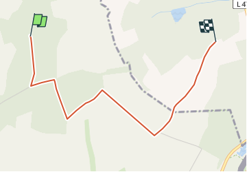
14,9 km | 18,1 km-effort
4h 6min
![](https://static1.geolcdn.com/siteimages/upload/files/16400158638029165_repeat_loop_refresh_sync_direction_icon.png)
Nein
![Tour Zu Fuß Blieskastel - Pirminiusweg - Photo](https://media.geolcdn.com/t/375/260/ext.jpg?maxdim=2&url=https%3A%2F%2Fmedia.geolcdn.com%2Ff%2Fc0514c31-b8dd-4a38-8935-b00dd723a0d0.jpeg)
![Zu Fuß Zu Fuß](https://static1.geolcdn.com/sitytour/trail-icons/100.png)
Pirminiusweg
Zu Fuß
Medium
Blieskastel,
Saarland,
Saarpfalz-Kreis,
Germany
![](/images/other/stat-length.png)
18,1 km | 22 km-effort
4h 58min
![](https://static1.geolcdn.com/siteimages/upload/files/16400158638029165_repeat_loop_refresh_sync_direction_icon.png)
Ja
![Tour Wandern Wollmünster - Moulin d'Eschviller et Ormersviller - Photo](https://media.geolcdn.com/t/375/260/ext.jpg?maxdim=2&url=https%3A%2F%2Fservices.sitytrail.com%2FGeolivesWS%2FDownloadMedia.ashx%3FTrailID%3D317660%26Media%3D16947_1.jpg)
![Wandern Wandern](https://static1.geolcdn.com/sitytour/trail-icons/101.png)
Moulin d'Eschviller et Ormersviller
Wandern
Medium
Wollmünster,
Großer Osten,
Mosel,
France
![](/images/other/stat-length.png)
11 km | 13,2 km-effort
2h 49min
![](https://static1.geolcdn.com/siteimages/upload/files/16400158638029165_repeat_loop_refresh_sync_direction_icon.png)
Ja
![Tour Wandern Blieskastel - Brenschelbach (D) 7 km 230225 - Photo](https://media.geolcdn.com/t/375/260/ext.jpg?maxdim=2&url=https%3A%2F%2Fmedia.geolcdn.com%2Ff%2F432d65a8-dedd-4cf2-af2f-08511efc4d95.jpg)
![Wandern Wandern](https://static1.geolcdn.com/sitytour/trail-icons/101.png)
Brenschelbach (D) 7 km 230225
Wandern
Einfach
Blieskastel,
Saarland,
Saarpfalz-Kreis,
Germany
![](/images/other/stat-length.png)
6,8 km | 8,3 km-effort
3h 8min
![](https://static1.geolcdn.com/siteimages/upload/files/16400158638029165_repeat_loop_refresh_sync_direction_icon.png)
Ja
![Tour Zu Fuß Blieskastel - Drei-Dörfer-Weg - Photo](https://media.geolcdn.com/t/375/260/ext.jpg?maxdim=2&url=https%3A%2F%2Fstatic1.geolcdn.com%2Fsiteimages%2Fupload%2Ffiles%2F1545311037marcheuse_200dpi.jpg)
![Zu Fuß Zu Fuß](https://static1.geolcdn.com/sitytour/trail-icons/100.png)
Drei-Dörfer-Weg
Zu Fuß
Einfach
Blieskastel,
Saarland,
Saarpfalz-Kreis,
Germany
![](/images/other/stat-length.png)
8,9 km | 11,1 km-effort
2h 30min
![](https://static1.geolcdn.com/siteimages/upload/files/16400158638029165_repeat_loop_refresh_sync_direction_icon.png)
Ja
![Tour Zu Fuß Blieskastel - DE-Reh - Photo](https://media.geolcdn.com/t/375/260/ext.jpg?maxdim=2&url=https%3A%2F%2Fstatic1.geolcdn.com%2Fsiteimages%2Fupload%2Ffiles%2F1545311037marcheuse_200dpi.jpg)
![Zu Fuß Zu Fuß](https://static1.geolcdn.com/sitytour/trail-icons/100.png)
![Tour Zu Fuß Gersheim - Nordic-Walking-Weg 6 - Photo](https://media.geolcdn.com/t/375/260/ext.jpg?maxdim=2&url=https%3A%2F%2Fmedia.geolcdn.com%2Ff%2F643d6827-c7be-4272-959c-108c05174e9b.jpeg)
![Zu Fuß Zu Fuß](https://static1.geolcdn.com/sitytour/trail-icons/100.png)
Nordic-Walking-Weg 6
Zu Fuß
Einfach
Gersheim,
Saarland,
Saarpfalz-Kreis,
Germany
![](/images/other/stat-length.png)
6 km | 7,4 km-effort
1h 40min
![](https://static1.geolcdn.com/siteimages/upload/files/16400158638029165_repeat_loop_refresh_sync_direction_icon.png)
Nein
![Tour Wandern Wollmünster - sentier d'excellence moulin d'Eschviller chapelle St Joseph Ormersviller - Photo](https://media.geolcdn.com/t/375/260/ext.jpg?maxdim=2&url=https%3A%2F%2Fstatic1.geolcdn.com%2Fsiteimages%2Fupload%2Ffiles%2F1553511878bg_sport_marche.png)
![Wandern Wandern](https://static1.geolcdn.com/sitytour/trail-icons/101.png)
sentier d'excellence moulin d'Eschviller chapelle St Joseph Ormersviller
Wandern
Einfach
Wollmünster,
Großer Osten,
Mosel,
France
![](/images/other/stat-length.png)
8,1 km | 9,9 km-effort
2h 18min
![](https://static1.geolcdn.com/siteimages/upload/files/16400158638029165_repeat_loop_refresh_sync_direction_icon.png)
Ja