![](/images/other/stat-length.png)
![Tour Zu Fuß Flüelen - Wildheupfad - Photo](https://media.geolcdn.com/t/1900/400/ext.pjpeg?maxdim=2&url=https%3A%2F%2Fmedia.geolcdn.com%2Ff%2F33bc141d-4e96-4498-b249-f0289ac01b32.jpeg)
Wildheupfad
SityTrail - itinéraires balisés pédestres
Tous les sentiers balisés d’Europe PRO
![Länge](/images/other/stat-length.png)
Länge
7,3 km
![Maximale Höhe](https://static1.geolcdn.com/siteimages/upload/files/1508320355ic_sort_altitude_max_24dp.png)
Maximale Höhe
1555 m
![Positive Höhendifferenz](https://static1.geolcdn.com/siteimages/upload/files/1508320355ic_sort_den_pos_24dp.png)
Positive Höhendifferenz
651 m
![Km-Effort](/images/other/stat-length.png)
Km-Effort
14,5 km
![Min. Höhe](https://static1.geolcdn.com/siteimages/upload/files/1508320355ic_sort_altitude_min_24dp.png)
Min. Höhe
997 m
![Negative Höhendifferenz](https://static1.geolcdn.com/siteimages/upload/files/1508320355ic_sort_den_neg_24dp.png)
Negative Höhendifferenz
201 m
![Boucle](https://static1.geolcdn.com/siteimages/upload/files/16400158638029165_repeat_loop_refresh_sync_direction_icon.png)
Boucle
Nein
Kennzeichnung
Erstellungsdatum :
2022-02-14 08:49:13.908
Letzte Änderung :
2022-02-14 08:49:13.908
![Zu Fuß](https://static1.geolcdn.com/sitytour/trail-icons/100.png)
3h17
Schwierigkeit : Einfach
![Scannen Sie diesen QR-Code, um die Tour in der SityTrail-Anwendung zu öffnen](https://capi.geolives.com/qq0zvz2zws4bq2lad0pu/sitytour/trails/3106238/qr.png?size=200)
Kostenlosegpshiking-Anwendung
Über SityTrail
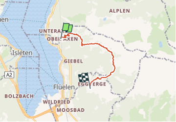
Tour Zu Fuß von 7,3 km verfügbar auf Uri, Unbekannt, Flüelen. Diese Tour wird von SityTrail - itinéraires balisés pédestres vorgeschlagen.
Beschreibung
Trail created by Wanderland Schweiz.
Teilstrecke Franzen-Oberaxen
Symbol: weiss-rot-weiss
Ort
Land:
Switzerland
Region :
Uri
Abteilung/Provinz :
Unbekannt
Kommune :
Flüelen
Standort:
Unknown
Gehen Sie:(Dec)
Gehen Sie:(UTM)
471317 ; 5196984 (32T) N.
Kommentare
Touren in der Umgebung
![Tour Zu Fuß Morschach - Furgeli - Chlingenstock - Photo](https://media.geolcdn.com/t/375/260/ext.jpg?maxdim=2&url=https%3A%2F%2Fmedia.geolcdn.com%2Ff%2F7158b266-84ca-491f-b823-c61d69de5f50.jpeg)
![Zu Fuß Zu Fuß](https://static1.geolcdn.com/sitytour/trail-icons/100.png)
Furgeli - Chlingenstock
Zu Fuß
Einfach
Morschach,
Schwyz,
Schwyz,
Switzerland
![](/images/other/stat-length.png)
3,2 km | 6,2 km-effort
1h 23min
![](https://static1.geolcdn.com/siteimages/upload/files/16400158638029165_repeat_loop_refresh_sync_direction_icon.png)
Nein
![Tour Zu Fuß Seedorf (UR) - Bauen-Schloss Beroldingen - Photo](https://media.geolcdn.com/t/375/260/ext.jpg?maxdim=2&url=https%3A%2F%2Fmedia.geolcdn.com%2Ff%2F96bcd15d-b3da-477d-bf24-53be113f3dfb.jpeg)
![Zu Fuß Zu Fuß](https://static1.geolcdn.com/sitytour/trail-icons/100.png)
Bauen-Schloss Beroldingen
Zu Fuß
Einfach
Seedorf (UR),
Uri,
Unbekannt,
Switzerland
![](/images/other/stat-length.png)
3,1 km | 7,4 km-effort
1h 40min
![](https://static1.geolcdn.com/siteimages/upload/files/16400158638029165_repeat_loop_refresh_sync_direction_icon.png)
Nein
![Tour Andere Aktivitäten Isenthal - y10_Isenthal - Photo](https://media.geolcdn.com/t/375/260/ext.jpg?maxdim=2&url=https%3A%2F%2Fstatic1.geolcdn.com%2Fsiteimages%2Fupload%2Ffiles%2F1545311037marcheuse_200dpi.jpg)
![Andere Aktivitäten Andere Aktivitäten](https://static1.geolcdn.com/sitytour/trail-icons/900.png)
y10_Isenthal
Andere Aktivitäten
Sehr leicht
Isenthal,
Uri,
Unbekannt,
Switzerland
![](/images/other/stat-length.png)
5 km | 8,9 km-effort
1h 48min
![](https://static1.geolcdn.com/siteimages/upload/files/16400158638029165_repeat_loop_refresh_sync_direction_icon.png)
Nein
![Tour Andere Aktivitäten Altdorf (UR) - y10_fluelen - Photo](https://media.geolcdn.com/t/375/260/ext.jpg?maxdim=2&url=https%3A%2F%2Fstatic1.geolcdn.com%2Fsiteimages%2Fupload%2Ffiles%2F1545311037marcheuse_200dpi.jpg)
![Andere Aktivitäten Andere Aktivitäten](https://static1.geolcdn.com/sitytour/trail-icons/900.png)
y10_fluelen
Andere Aktivitäten
Sehr leicht
Altdorf (UR),
Uri,
Unbekannt,
Switzerland
![](/images/other/stat-length.png)
12,9 km | 19,7 km-effort
4h 40min
![](https://static1.geolcdn.com/siteimages/upload/files/16400158638029165_repeat_loop_refresh_sync_direction_icon.png)
Nein
![Tour Schneeschuhwandern Altdorf (UR) - Eggberge -- Selez Schneeschuhtour - Photo](https://media.geolcdn.com/t/375/260/ext.jpg?maxdim=2&url=https%3A%2F%2Fstatic1.geolcdn.com%2Fsiteimages%2Fupload%2Ffiles%2F1524743153raquette.jpg)
![Schneeschuhwandern Schneeschuhwandern](https://static1.geolcdn.com/sitytour/trail-icons/504.png)
Eggberge -- Selez Schneeschuhtour
Schneeschuhwandern
Sehr leicht
Altdorf (UR),
Uri,
Unbekannt,
Switzerland
![](/images/other/stat-length.png)
5,2 km | 9,9 km-effort
2h 20min
![](https://static1.geolcdn.com/siteimages/upload/files/16400158638029165_repeat_loop_refresh_sync_direction_icon.png)
Nein
![Tour Mountainbike Flüelen - Schächental - Photo](https://media.geolcdn.com/t/375/260/ext.jpg?maxdim=2&url=https%3A%2F%2Fstatic1.geolcdn.com%2Fsiteimages%2Fupload%2Ffiles%2F1524743154velo.jpg)
![Mountainbike Mountainbike](https://static1.geolcdn.com/sitytour/trail-icons/202.png)
Schächental
Mountainbike
Sehr leicht
Flüelen,
Uri,
Unbekannt,
Switzerland
![](/images/other/stat-length.png)
49 km | 77 km-effort
16h 33min
![](https://static1.geolcdn.com/siteimages/upload/files/16400158638029165_repeat_loop_refresh_sync_direction_icon.png)
Ja
![Tour Wandern Altdorf (UR) - Eggberge - Photo](https://media.geolcdn.com/t/375/260/ext.jpg?maxdim=2&url=https%3A%2F%2Fstatic1.geolcdn.com%2Fsiteimages%2Fupload%2Ffiles%2F1553511878bg_sport_marche.png)
![Wandern Wandern](https://static1.geolcdn.com/sitytour/trail-icons/101.png)
Eggberge
Wandern
Sehr leicht
Altdorf (UR),
Uri,
Unbekannt,
Switzerland
![](/images/other/stat-length.png)
9,6 km | 28 km-effort
2h 46min
![](https://static1.geolcdn.com/siteimages/upload/files/16400158638029165_repeat_loop_refresh_sync_direction_icon.png)
Nein
![Tour Wandern Seelisberg - Der Weg der Schweiz: Traumwege am Urnersee - Photo](https://media.geolcdn.com/t/375/260/ext.jpg?maxdim=2&url=https%3A%2F%2Fstatic1.geolcdn.com%2Fsiteimages%2Fupload%2Ffiles%2F1553511878bg_sport_marche.png)
![Wandern Wandern](https://static1.geolcdn.com/sitytour/trail-icons/101.png)
Der Weg der Schweiz: Traumwege am Urnersee
Wandern
Sehr leicht
Seelisberg,
Uri,
Unbekannt,
Switzerland
![](/images/other/stat-length.png)
33 km | 53 km-effort
13h 48min
![](https://static1.geolcdn.com/siteimages/upload/files/16400158638029165_repeat_loop_refresh_sync_direction_icon.png)
Nein
![Tour Wandern Flüelen - Höhenwanderung über dem Schächental - Photo](https://media.geolcdn.com/t/375/260/ext.jpg?maxdim=2&url=https%3A%2F%2Fstatic1.geolcdn.com%2Fsiteimages%2Fupload%2Ffiles%2F1553511878bg_sport_marche.png)
![Wandern Wandern](https://static1.geolcdn.com/sitytour/trail-icons/101.png)
Höhenwanderung über dem Schächental
Wandern
Sehr leicht
Flüelen,
Uri,
Unbekannt,
Switzerland
![](/images/other/stat-length.png)
23 km | 46 km-effort
Unbekannt
![](https://static1.geolcdn.com/siteimages/upload/files/16400158638029165_repeat_loop_refresh_sync_direction_icon.png)
Nein