Tour Zu Fuß Rapilly - Circuit de la Vallée de la Baize - Photo

Circuit de la Vallée de la Baize

Tous les sentiers balisés d’Europe PRO

© OpenStreetMap contributors
Länge
Länge
7,3 km
Maximale Höhe
Maximale Höhe
210 m
Positive Höhendifferenz
168 m
Km-Effort
Km-Effort  
9,5 km
Min. Höhe
Min. Höhe
65 m
Negative Höhendifferenz
169 m
Boucle
Boucle
Ja
Kennzeichnung
Kennzeichnung
Erstellungsdatum :
2022-02-15 04:31:38.388
Letzte Änderung :
2022-03-02 12:39:24.185

(1 Nachricht)

Zu Fuß
Zu Fuß
2h09
Schwierigkeit : Einfach

Scannen Sie diesen QR-Code, um die Tour in der SityTrail-Anwendung zu öffnen

Kostenlosegpshiking-Anwendung

Logo SityTrail SityTrail

IGN / Geografische Institute

SityTrail aus dem App Store herunterladen SityTrail von Google Play herunterladen

Logo SityTrail SityTrail World

Die Welt öffnet sich für Sie

SityTrail aus dem App Store herunterladen SityTrail von Google Play herunterladen SityTrail auf Huawei AppGallery herunterladen

Über SityTrail

Tour Zu Fuß von 7,3 km verfügbar auf Normandie, Calvados, Rapilly. Diese Tour wird von SityTrail - itinéraires balisés pédestres vorgeschlagen.

Ort

Land:
France
Region :
Normandie
Abteilung/Provinz :
Calvados
Kommune :
Rapilly
Standort:
Unknown
Gehen Sie:(UTM)
693361 ; 5414398 (30U) N.

Kommentare

Bitte melden Sie sich an, um einen Kommentar oder eine Bewertung zu hinterlassen


Touren in der Umgebung

Tour Mountainbike Pont-d'Ouilly - La Petite Suisse Normande 2014 - Pont-d'Ouilly - Photo
Mountainbike
tracegps

Mountainbike

Schwierig
(1)
Pont-d'Ouilly, Normandie, Calvados, France
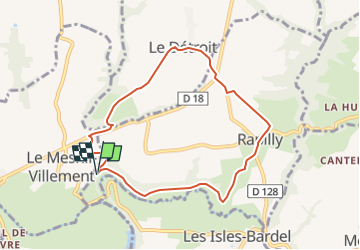
41 km | 54 km-effort
3h 30min
Ja
Tour Wandern Saint-Philbert-sur-Orne - Autour des roches d'oetre - Photo
Wandern
phi14

Wandern

Einfach
(3)
Saint-Philbert-sur-Orne, Normandie, Orne, France
9,7 km | 12,4 km-effort
2h 30min
Ja
Tour Wandern Athis-Val-de-Rouvre - Rando botanique  - Ségrie Fontaine  - Photo
Wandern
tracegps

Wandern

Medium
(2)
Athis-Val-de-Rouvre, Normandie, Orne, France
10,4 km | 13,4 km-effort
3h 40min
Ja
Tour Wandern Saint-Philbert-sur-Orne - Roche d’oëtre sentier du Granite - Photo
Wandern
zefreefly

Wandern

Sehr leicht
Saint-Philbert-sur-Orne, Normandie, Orne, France
10,1 km | 12,7 km-effort
2h 43min
Ja
Tour Wandern Saint-Philbert-sur-Orne - Circuit des méandres  - Photo
Wandern
JLPIERSON

Wandern

Medium
Saint-Philbert-sur-Orne, Normandie, Orne, France
6,4 km | 8,4 km-effort
1h 54min
Ja
Tour Wandern Ménil-Hubert-sur-Orne - De Rouvroy aux Roches d'Oetre par le sentier des Méandres  - Photo
Wandern
Ecureuiltrailer

Wandern

Medium
Ménil-Hubert-sur-Orne, Normandie, Orne, France
7,1 km | 9,3 km-effort
2h 1min
Ja
Tour Zu Fuß Athis-Val-de-Rouvre - Les Fontaines - Photo
Zu Fuß
PRO

Zu Fuß

Einfach
Athis-Val-de-Rouvre, Normandie, Orne, France
5,7 km | 7,3 km-effort
1h 38min
Ja
Tour Zu Fuß Athis-Val-de-Rouvre - Sentier du granite - Photo
Zu Fuß
PRO

Zu Fuß

Einfach
(1)
Athis-Val-de-Rouvre, Normandie, Orne, France
8,6 km | 11 km-effort
2h 30min
Ja
Tour Zu Fuß Saint-Philbert-sur-Orne - Entre Orne et Rouvre - Photo
Zu Fuß
PRO

Zu Fuß

Einfach
Saint-Philbert-sur-Orne, Normandie, Orne, France
7,7 km | 10,3 km-effort
2h 19min
Ja


Schließen
Meine Abonnements