


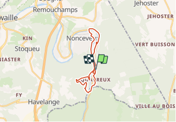
Fond de Quarreux left bank of the Ambléve

Geert H.
Benutzer

Länge
9,6 km

Maximale Höhe
315 m

Positive Höhendifferenz
278 m
Km-Effort
13,3 km

Min. Höhe
154 m

Negative Höhendifferenz
278 m
Boucle
Ja
Erstellungsdatum :
2022-03-06 17:29:39.567
Letzte Änderung :
2022-03-07 09:14:33.851
3h01
Schwierigkeit : Schwierig

Kostenlosegpshiking-Anwendung
 SityTrail
IGN / Geografische Institute
SityTrail Plus
Die Welt öffnet sich für Sie
Über SityTrail
Tour Wandern von 9,6 km verfügbar auf Wallonien, Lüttich, Aywaille. Diese Tour wird von Geert H. vorgeschlagen.
Beschreibung
Walking along thre left bank of the Ambléve but with a bite going up a some hills at the beginning.
Ort
Land:
Belgium
Region :
Wallonien
Abteilung/Provinz :
Lüttich
Kommune :
Aywaille
Standort:
Unknown
Gehen Sie:(Dec)
Gehen Sie:(UTM)
694620 ; 5592507 (31U) N.
Kommentare