Tour Mountainbike Sainte-Croix - VTT Ste Croix -Crx de Belges 29km 500D+  04 JUIL 2023 Didier Vincent - Photo

VTT Ste Croix -Crx de Belges 29km 500D+ 04 JUIL 2023 Didier Vincent

© OpenStreetMap contributors
Länge
Länge
29 km
Maximale Höhe
Maximale Höhe
399 m
Positive Höhendifferenz
470 m
Km-Effort
Km-Effort  
35 km
Min. Höhe
Min. Höhe
213 m
Negative Höhendifferenz
471 m
Boucle
Boucle
Ja
Erstellungsdatum :
2023-07-07 15:04:20.526
Letzte Änderung :
2023-07-07 15:06:48.475

(0 Nachricht)

Mountainbike
Mountainbike
2h25
Schwierigkeit : Einfach

Scannen Sie diesen QR-Code, um die Tour in der SityTrail-Anwendung zu öffnen

Kostenlosegpshiking-Anwendung

Logo SityTrail SityTrail

IGN / Geografische Institute

SityTrail aus dem App Store herunterladen SityTrail von Google Play herunterladen

Logo SityTrail SityTrail World

Die Welt öffnet sich für Sie

SityTrail aus dem App Store herunterladen SityTrail von Google Play herunterladen SityTrail auf Huawei AppGallery herunterladen

Über SityTrail

Tour Mountainbike von 29 km verfügbar auf Okzitanien, Aveyron, Sainte-Croix. Diese Tour wird von Levillefranchois vorgeschlagen.

Beschreibung

Pas de difficultés particulieres
Pas de portage
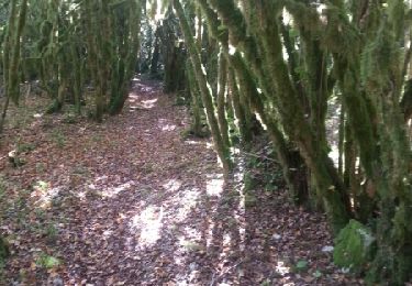
Descente dans la forêt des buis
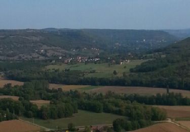
Panorama de la Croix des Belges

Höhenprofil

Ort

Land:
France
Region :
Okzitanien
Abteilung/Provinz :
Aveyron
Kommune :
Sainte-Croix
Standort:
Unknown
Gehen Sie:(UTM)
417729 ; 4919838 (31T) N.

Touren in der Umgebung

Tour Zu Fuß Sainte-Croix - Balade autour de Sainte-Croix - Circuit 1 - Photo
Zu Fuß
PRO

Zu Fuß

Einfach
Sainte-Croix, Okzitanien, Aveyron, France
4,2 km | 5,3 km-effort
1h 12min
Ja
Tour Zu Fuß Sainte-Croix - Balade autour de Sainte-Croix - Circuit 2 - Photo
Zu Fuß
PRO

Zu Fuß

Einfach
Sainte-Croix, Okzitanien, Aveyron, France
4,9 km | 6,2 km-effort
1h 24min
Nein
Tour Zu Fuß Sainte-Croix - Balade autour de Sainte-Croix - Circuit 3 - Photo
Zu Fuß
PRO

Zu Fuß

Einfach
Sainte-Croix, Okzitanien, Aveyron, France
6,5 km | 8,1 km-effort
1h 50min
Ja
Tour Zu Fuß Sainte-Croix - Circuit des 3 clochers - Photo
Zu Fuß
PRO

Zu Fuß

Einfach
Sainte-Croix, Okzitanien, Aveyron, France
13,9 km | 17,4 km-effort
3h 57min
Ja
Tour Mountainbike La Capelle-Balaguier - la capelle maroule puyjourdes loule anglars les buis lacapelle - Photo
Mountainbike
Gerard_Soulie

Mountainbike

Medium
La Capelle-Balaguier, Okzitanien, Aveyron, France
31 km | 40 km-effort
2h 52min
Ja
Tour Mountainbike La Capelle-Balaguier - la capelle anglars estrabols borieangle croix belge saut mounine trep et retour lac - Photo
Mountainbike
Gerard_Soulie

Mountainbike

Medium
La Capelle-Balaguier, Okzitanien, Aveyron, France
32 km | 40 km-effort
3h 8min
Ja
Tour Wandern La Capelle-Balaguier - Boucle de Lacapelle Balaguier - Photo
Wandern
tracegps

Wandern

Medium
La Capelle-Balaguier, Okzitanien, Aveyron, France
14 km | 18,4 km-effort
3h 0min
Ja
Tour Mountainbike Sainte-Croix - VTT Ste Croix 18km 400D+ 2023-09-16 - Photo
Mountainbike
Levillefranchois

Mountainbike

Einfach
Sainte-Croix, Okzitanien, Aveyron, France
18,4 km | 23 km-effort
1h 35min
Ja
Tour Mountainbike La Capelle-Balaguier - VTT La Capelle 31km 750D+(Mag, Chris, Didier,Pascal) 2021-11-16 - Photo
Mountainbike
Levillefranchois

Mountainbike

Einfach
La Capelle-Balaguier, Okzitanien, Aveyron, France
31 km | 39 km-effort
2h 43min
Ja


Schließen
Meine Abonnements