![](/images/other/stat-length.png)
![Tour Wandern Monchy-Lagache - Circuit de Monchy-Lagache , Caulaincourt - Photo](https://media.geolcdn.com/t/1900/400/ext.pjpeg?maxdim=2&url=https%3A%2F%2Fstatic1.geolcdn.com%2Fsiteimages%2Fupload%2Ffiles%2F1553511878bg_sport_marche.png)
Circuit de Monchy-Lagache , Caulaincourt
José800
Benutzer
![Länge](/images/other/stat-length.png)
Länge
12,1 km
![Maximale Höhe](https://static1.geolcdn.com/siteimages/upload/files/1508320355ic_sort_altitude_max_24dp.png)
Maximale Höhe
100 m
![Positive Höhendifferenz](https://static1.geolcdn.com/siteimages/upload/files/1508320355ic_sort_den_pos_24dp.png)
Positive Höhendifferenz
112 m
![Km-Effort](/images/other/stat-length.png)
Km-Effort
13,6 km
![Min. Höhe](https://static1.geolcdn.com/siteimages/upload/files/1508320355ic_sort_altitude_min_24dp.png)
Min. Höhe
59 m
![Negative Höhendifferenz](https://static1.geolcdn.com/siteimages/upload/files/1508320355ic_sort_den_neg_24dp.png)
Negative Höhendifferenz
110 m
![Boucle](https://static1.geolcdn.com/siteimages/upload/files/16400158638029165_repeat_loop_refresh_sync_direction_icon.png)
Boucle
Ja
Erstellungsdatum :
2023-10-20 19:52:20.834
Letzte Änderung :
2023-10-20 20:08:37.654
![Wandern](https://static1.geolcdn.com/sitytour/trail-icons/101.png)
3h05
Schwierigkeit : Schwierig
![Scannen Sie diesen QR-Code, um die Tour in der SityTrail-Anwendung zu öffnen](https://capi.geolives.com/qq0zvz2zws4bq2lad0pu/sitytour/trails/3845582/qr.png?size=200)
Kostenlosegpshiking-Anwendung
Über SityTrail
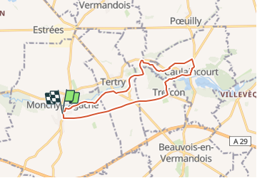
Tour Wandern von 12,1 km verfügbar auf Nordfrankreich, Somme, Monchy-Lagache. Diese Tour wird von José800 vorgeschlagen.
Beschreibung
L' Omignon musarde entre Trefcon et Caulaincourt avec son cortége d 'etangs et de bois . Après L' etang de Caulaincourt , ce circuit tranquille et ombragé rejoint les ruines de l' église Saint Martin- des-Prés .
Ort
Land:
France
Region :
Nordfrankreich
Abteilung/Provinz :
Somme
Kommune :
Monchy-Lagache
Standort:
Unknown
Gehen Sie:(Dec)
Gehen Sie:(UTM)
503243 ; 5522181 (31U) N.
Kommentare
Touren in der Umgebung
![Tour Wandern Trefcon - Saint-Martin-des-Prés - Photo](https://media.geolcdn.com/t/375/260/ext.jpg?maxdim=2&url=https%3A%2F%2Fservices.sitytrail.com%2FGeolivesWS%2FDownloadMedia.ashx%3FTrailID%3D202849%26Media%3D09d22638-1ecc-4bf7-a110-8c7f3bb2d6e5.jpg)
![Wandern Wandern](https://static1.geolcdn.com/sitytour/trail-icons/101.png)
Saint-Martin-des-Prés
Wandern
Sehr leicht
Trefcon,
Nordfrankreich,
Aisne,
France
![](/images/other/stat-length.png)
5,7 km | 6,4 km-effort
Unbekannt
![](https://static1.geolcdn.com/siteimages/upload/files/16400158638029165_repeat_loop_refresh_sync_direction_icon.png)
Ja
![Tour Wandern Tertry - Tertry80 - Photo](https://media.geolcdn.com/t/375/260/ext.jpg?maxdim=2&url=https%3A%2F%2Fmedia.geolcdn.com%2Ff%2F2999adf9-a8d9-4d12-a54a-be5b4b28b8e8.jpg)
![Wandern Wandern](https://static1.geolcdn.com/sitytour/trail-icons/101.png)
![Tour Wandern Caulaincourt - Tréfonds 2022 - Photo](https://media.geolcdn.com/t/375/260/ext.jpg?maxdim=2&url=https%3A%2F%2Fmedia.geolcdn.com%2Ff%2F9d4deb00-e196-4fc9-a21d-a58974aed1a5.jpg)
![Wandern Wandern](https://static1.geolcdn.com/sitytour/trail-icons/101.png)
Tréfonds 2022
Wandern
Caulaincourt,
Nordfrankreich,
Aisne,
France
![](/images/other/stat-length.png)
6,4 km | 7,2 km-effort
1h 26min
![](https://static1.geolcdn.com/siteimages/upload/files/16400158638029165_repeat_loop_refresh_sync_direction_icon.png)
Ja
![Tour Wandern Trefcon - Saint-Martin-des-Prés - Photo](https://media.geolcdn.com/t/375/260/ext.jpg?maxdim=2&url=https%3A%2F%2Fservices.sitytrail.com%2FGeolivesWS%2FDownloadMedia.ashx%3FTrailID%3D108369%26Media%3D1053_1.jpg)
![Wandern Wandern](https://static1.geolcdn.com/sitytour/trail-icons/101.png)
Saint-Martin-des-Prés
Wandern
Einfach
Trefcon,
Nordfrankreich,
Aisne,
France
![](/images/other/stat-length.png)
5,7 km | 6,4 km-effort
2h 0min
![](https://static1.geolcdn.com/siteimages/upload/files/16400158638029165_repeat_loop_refresh_sync_direction_icon.png)
Ja
![Tour Kutsche fahren Monchy-Lagache - 28/03/22 - Photo](https://media.geolcdn.com/t/375/260/ext.jpg?maxdim=2&url=https%3A%2F%2Fstatic1.geolcdn.com%2Fsiteimages%2Fupload%2Ffiles%2F1524743154cheval.jpg)
![Kutsche fahren Kutsche fahren](https://static1.geolcdn.com/sitytour/trail-icons/302.png)
28/03/22
Kutsche fahren
Monchy-Lagache,
Nordfrankreich,
Somme,
France
![](/images/other/stat-length.png)
8,7 km | 9,5 km-effort
1h 3min
![](https://static1.geolcdn.com/siteimages/upload/files/16400158638029165_repeat_loop_refresh_sync_direction_icon.png)
Nein
![Tour Zu Fuß Athies - La vallée de la marche verte à Athies 80 - Photo](https://media.geolcdn.com/t/375/260/ext.jpg?maxdim=2&url=https%3A%2F%2Fstatic1.geolcdn.com%2Fsiteimages%2Fupload%2Ffiles%2F1545311037marcheuse_200dpi.jpg)
![Zu Fuß Zu Fuß](https://static1.geolcdn.com/sitytour/trail-icons/100.png)
La vallée de la marche verte à Athies 80
Zu Fuß
Einfach
Athies,
Nordfrankreich,
Somme,
France
![](/images/other/stat-length.png)
10,4 km | 11,7 km-effort
2h 40min
![](https://static1.geolcdn.com/siteimages/upload/files/16400158638029165_repeat_loop_refresh_sync_direction_icon.png)
Ja
![Tour Wandern Athies - ATHIES (80) - La Vallée de la Marche Verte - Photo](https://media.geolcdn.com/t/375/260/ext.jpg?maxdim=2&url=https%3A%2F%2Fstatic1.geolcdn.com%2Fsiteimages%2Fupload%2Ffiles%2F1553511878bg_sport_marche.png)
![Wandern Wandern](https://static1.geolcdn.com/sitytour/trail-icons/101.png)
ATHIES (80) - La Vallée de la Marche Verte
Wandern
Medium
Athies,
Nordfrankreich,
Somme,
France
![](/images/other/stat-length.png)
10,4 km | 11,7 km-effort
2h 39min
![](https://static1.geolcdn.com/siteimages/upload/files/16400158638029165_repeat_loop_refresh_sync_direction_icon.png)
Ja
![Tour Zu Fuß Monchy-Lagache - la vallée de l eau Mignonne - Photo](https://media.geolcdn.com/t/375/260/ext.jpg?maxdim=2&url=https%3A%2F%2Fstatic1.geolcdn.com%2Fsiteimages%2Fupload%2Ffiles%2F1545311037marcheuse_200dpi.jpg)
![Zu Fuß Zu Fuß](https://static1.geolcdn.com/sitytour/trail-icons/100.png)
la vallée de l eau Mignonne
Zu Fuß
Einfach
Monchy-Lagache,
Nordfrankreich,
Somme,
France
![](/images/other/stat-length.png)
9,5 km | 10,7 km-effort
2h 25min
![](https://static1.geolcdn.com/siteimages/upload/files/16400158638029165_repeat_loop_refresh_sync_direction_icon.png)
Ja
![Tour Wandern Tertry - Tertry 80 - Photo](https://media.geolcdn.com/t/375/260/ext.jpg?maxdim=2&url=https%3A%2F%2Fstatic1.geolcdn.com%2Fsiteimages%2Fupload%2Ffiles%2F1553511878bg_sport_marche.png)
![Wandern Wandern](https://static1.geolcdn.com/sitytour/trail-icons/101.png)