


castirando 2024

mthomas30
Benutzer
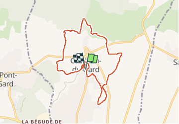

Länge
9,7 km

Maximale Höhe
102 m

Positive Höhendifferenz
192 m
Km-Effort
12,3 km

Min. Höhe
42 m

Negative Höhendifferenz
192 m
Boucle
Ja
Erstellungsdatum :
2024-03-02 14:56:37.537
Letzte Änderung :
2024-03-02 17:21:06.687
2h07
Schwierigkeit : Medium

Kostenlosegpshiking-Anwendung
 SityTrail
IGN / Geografische Institute
SityTrail Plus
Die Welt öffnet sich für Sie
Über SityTrail
Tour Wandern von 9,7 km verfügbar auf Okzitanien, Gard, Castillon-du-Gard. Diese Tour wird von mthomas30 vorgeschlagen.
Ort
Land:
France
Region :
Okzitanien
Abteilung/Provinz :
Gard
Kommune :
Castillon-du-Gard
Standort:
Unknown
Gehen Sie:(Dec)
Gehen Sie:(UTM)
624696 ; 4869644 (31T) N.
Kommentare