


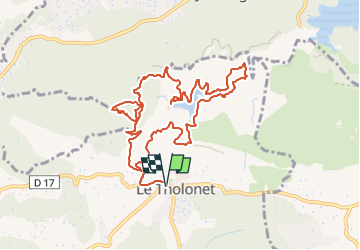
De part et d'autre de la Cause et du Lac Zola

Nathy8913
Benutzer

Länge
12 km

Maximale Höhe
354 m

Positive Höhendifferenz
413 m
Km-Effort
17,5 km

Min. Höhe
179 m

Negative Höhendifferenz
413 m
Boucle
Ja
Erstellungsdatum :
2024-06-14 07:26:05.559
Letzte Änderung :
2024-06-14 07:28:41.427
3h58
Schwierigkeit : Schwierig

Kostenlosegpshiking-Anwendung
 SityTrail
IGN / Geografische Institute
SityTrail Plus
Die Welt öffnet sich für Sie
Über SityTrail
Tour Wandern von 12 km verfügbar auf Provence-Alpes-Côte d'Azur, Bouches-du-Rhône, Le Tholonet. Diese Tour wird von Nathy8913 vorgeschlagen.
POIs


Ort
Land:
France
Region :
Provence-Alpes-Côte d'Azur
Abteilung/Provinz :
Bouches-du-Rhône
Kommune :
Le Tholonet
Standort:
Unknown
Gehen Sie:(Dec)
Gehen Sie:(UTM)
702881 ; 4821847 (31T) N.
Kommentare