![](/images/other/stat-length.png)
![Tour Wandern Sebourg - randonnée 1 remise en forme - Photo](https://media.geolcdn.com/t/1900/400/ext.pjpeg?maxdim=2&url=https%3A%2F%2Fservices.sitytrail.com%2FGeolivesWS%2FDownloadMedia.ashx%3FTrailID%3D693288%26Media%3Dd054f837-90e4-4f6b-a3f9-2a36611de04a.jpg)
randonnée 1 remise en forme
corsinou
Benutzer
![Länge](/images/other/stat-length.png)
Länge
7,5 km
![Maximale Höhe](https://static1.geolcdn.com/siteimages/upload/files/1508320355ic_sort_altitude_max_24dp.png)
Maximale Höhe
88 m
![Positive Höhendifferenz](https://static1.geolcdn.com/siteimages/upload/files/1508320355ic_sort_den_pos_24dp.png)
Positive Höhendifferenz
77 m
![Km-Effort](/images/other/stat-length.png)
Km-Effort
8,5 km
![Min. Höhe](https://static1.geolcdn.com/siteimages/upload/files/1508320355ic_sort_altitude_min_24dp.png)
Min. Höhe
46 m
![Negative Höhendifferenz](https://static1.geolcdn.com/siteimages/upload/files/1508320355ic_sort_den_neg_24dp.png)
Negative Höhendifferenz
75 m
![Boucle](https://static1.geolcdn.com/siteimages/upload/files/16400158638029165_repeat_loop_refresh_sync_direction_icon.png)
Boucle
Ja
Erstellungsdatum :
2017-02-04 00:00:00.0
Letzte Änderung :
2017-02-04 00:00:00.0
![Wandern](https://static1.geolcdn.com/sitytour/trail-icons/101.png)
1h40
Schwierigkeit : Einfach
![Scannen Sie diesen QR-Code, um die Tour in der SityTrail-Anwendung zu öffnen](https://capi.geolives.com/qq0zvz2zws4bq2lad0pu/sitytour/trails/693288/qr.png?size=200)
Kostenlosegpshiking-Anwendung
Über SityTrail
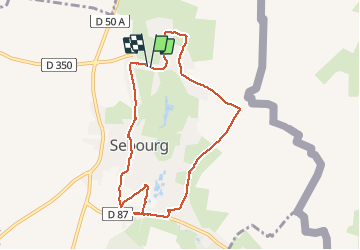
Tour Wandern von 7,5 km verfügbar auf Nordfrankreich, Nord, Sebourg. Diese Tour wird von corsinou vorgeschlagen.
Beschreibung
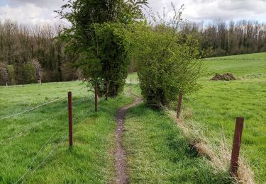
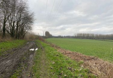
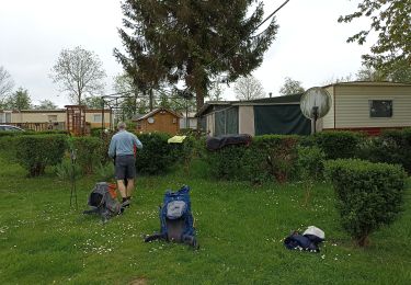
Petite rando sympa trés facile à faire en famille au bon temps.
En cette période d'hiver, prévoir de bonne chaussures de marche étanche. Chemin légèrement boueux.
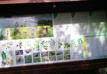
A cette période faune abondante à qui sait être observateur et silencieux, renard, lapins, écureuils, corbeaux etc.
Ort
Land:
France
Region :
Nordfrankreich
Abteilung/Provinz :
Nord
Kommune :
Sebourg
Standort:
Unknown
Gehen Sie:(Dec)
Gehen Sie:(UTM)
546102 ; 5577852 (31U) N.
Kommentare
Touren in der Umgebung
![Tour Wandern Honnelles - Cani-Rando au Caillou qui Bique - Photo](https://media.geolcdn.com/t/375/260/ext.jpg?maxdim=2&url=https%3A%2F%2Fmedia.geolcdn.com%2Ff%2F5f136b8b-6c39-49a4-8827-2c425695ee60.jpg)
![Wandern Wandern](https://static1.geolcdn.com/sitytour/trail-icons/101.png)
Cani-Rando au Caillou qui Bique
Wandern
Sehr leicht
(1)
Honnelles,
Wallonien,
Hennegau,
Belgium
![](/images/other/stat-length.png)
3,3 km | 4 km-effort
1h 25min
![](https://static1.geolcdn.com/siteimages/upload/files/16400158638029165_repeat_loop_refresh_sync_direction_icon.png)
Ja
![Tour Wandern Estreux - Balade à Estreux - Photo](https://media.geolcdn.com/t/375/260/ext.jpg?maxdim=2&url=https%3A%2F%2Fservices.sitytrail.com%2FGeolivesWS%2FDownloadMedia.ashx%3FTrailID%3D111675%26Media%3D7916_3.jpg)
![Wandern Wandern](https://static1.geolcdn.com/sitytour/trail-icons/101.png)
Balade à Estreux
Wandern
Medium
(1)
Estreux,
Nordfrankreich,
Nord,
France
![](/images/other/stat-length.png)
8,4 km | 9,4 km-effort
2h 10min
![](https://static1.geolcdn.com/siteimages/upload/files/16400158638029165_repeat_loop_refresh_sync_direction_icon.png)
Ja
![Tour Wandern Jenlain - Au départ de Jenlain - Photo](https://media.geolcdn.com/t/375/260/ext.jpg?maxdim=2&url=https%3A%2F%2Fservices.sitytrail.com%2FGeolivesWS%2FDownloadMedia.ashx%3FTrailID%3D109810%26Media%3D4753_5.jpg)
![Wandern Wandern](https://static1.geolcdn.com/sitytour/trail-icons/101.png)
Au départ de Jenlain
Wandern
Medium
(1)
Jenlain,
Nordfrankreich,
Nord,
France
![](/images/other/stat-length.png)
8,4 km | 9,7 km-effort
2h 10min
![](https://static1.geolcdn.com/siteimages/upload/files/16400158638029165_repeat_loop_refresh_sync_direction_icon.png)
Ja
![Tour Wandern Honnelles - Promenade du caillou qui bique - Photo](https://media.geolcdn.com/t/375/260/ext.jpg?maxdim=2&url=https%3A%2F%2Fmedia.geolcdn.com%2Ff%2Fcc0f30d2-5684-405d-8da2-669ce0391c1a.jpg)
![Wandern Wandern](https://static1.geolcdn.com/sitytour/trail-icons/101.png)
Promenade du caillou qui bique
Wandern
Medium
(1)
Honnelles,
Wallonien,
Hennegau,
Belgium
![](/images/other/stat-length.png)
6,5 km | 8,1 km-effort
1h 50min
![](https://static1.geolcdn.com/siteimages/upload/files/16400158638029165_repeat_loop_refresh_sync_direction_icon.png)
Ja
![Tour Wandern Jenlain - Jenlain 20,4 km - Photo](https://media.geolcdn.com/t/375/260/ext.jpg?maxdim=2&url=https%3A%2F%2Fmedia.geolcdn.com%2Ff%2Fdc2d7a99-90ba-4862-8b09-aa142eac1f9a.jpg)
![Wandern Wandern](https://static1.geolcdn.com/sitytour/trail-icons/101.png)
Jenlain 20,4 km
Wandern
Medium
Jenlain,
Nordfrankreich,
Nord,
France
![](/images/other/stat-length.png)
21 km | 24 km-effort
4h 54min
![](https://static1.geolcdn.com/siteimages/upload/files/16400158638029165_repeat_loop_refresh_sync_direction_icon.png)
Ja
![Tour Quad Sebourg - Sebourg - Photo](https://media.geolcdn.com/t/375/260/ext.jpg?maxdim=2&url=https%3A%2F%2Fstatic1.geolcdn.com%2Fsiteimages%2Fupload%2Ffiles%2F15247431544x4.jpg)
![Quad Quad](https://static1.geolcdn.com/sitytour/trail-icons/404.png)
Sebourg
Quad
Sehr leicht
(1)
Sebourg,
Nordfrankreich,
Nord,
France
![](/images/other/stat-length.png)
120 km | 133 km-effort
Unbekannt
![](https://static1.geolcdn.com/siteimages/upload/files/16400158638029165_repeat_loop_refresh_sync_direction_icon.png)
Ja
![Tour Wandern Honnelles - les jonquilles au caillou qui bique - Photo](https://media.geolcdn.com/t/375/260/ext.jpg?maxdim=2&url=https%3A%2F%2Fstatic1.geolcdn.com%2Fsiteimages%2Fupload%2Ffiles%2F1553511878bg_sport_marche.png)
![Wandern Wandern](https://static1.geolcdn.com/sitytour/trail-icons/101.png)
les jonquilles au caillou qui bique
Wandern
Einfach
(2)
Honnelles,
Wallonien,
Hennegau,
Belgium
![](/images/other/stat-length.png)
8,5 km | 10,3 km-effort
2h 6min
![](https://static1.geolcdn.com/siteimages/upload/files/16400158638029165_repeat_loop_refresh_sync_direction_icon.png)
Ja
![Tour Wandern Sebourg - Le Bois de Sebourg - Photo](https://media.geolcdn.com/t/375/260/ext.jpg?maxdim=2&url=https%3A%2F%2Fstatic1.geolcdn.com%2Fsiteimages%2Fupload%2Ffiles%2F1553511878bg_sport_marche.png)
![Wandern Wandern](https://static1.geolcdn.com/sitytour/trail-icons/101.png)
Le Bois de Sebourg
Wandern
Sehr leicht
(1)
Sebourg,
Nordfrankreich,
Nord,
France
![](/images/other/stat-length.png)
6,6 km | 7,7 km-effort
1h 41min
![](https://static1.geolcdn.com/siteimages/upload/files/16400158638029165_repeat_loop_refresh_sync_direction_icon.png)
Ja
![Tour Wandern Honnelles - de Roisin à Villiers Sire Nicole - Photo](https://media.geolcdn.com/t/375/260/ext.jpg?maxdim=2&url=https%3A%2F%2Fmedia.geolcdn.com%2Ff%2F5e56ca29-a3de-40b1-9548-713d7c3e013a.jpg)
![Wandern Wandern](https://static1.geolcdn.com/sitytour/trail-icons/101.png)
de Roisin à Villiers Sire Nicole
Wandern
Medium
Honnelles,
Wallonien,
Hennegau,
Belgium
![](/images/other/stat-length.png)
33 km | 37 km-effort
11h 29min
![](https://static1.geolcdn.com/siteimages/upload/files/16400158638029165_repeat_loop_refresh_sync_direction_icon.png)
Nein