![](/images/other/stat-length.png)
![Tour Wandern Hourtin - Gironde - Lac de Hourtin - bord de mer - Photo](https://media.geolcdn.com/t/1900/400/ext.pjpeg?maxdim=2&url=https%3A%2F%2Fstatic1.geolcdn.com%2Fsiteimages%2Fupload%2Ffiles%2F1553511878bg_sport_marche.png)
Gironde - Lac de Hourtin - bord de mer
ffffff
Benutzer
![Länge](/images/other/stat-length.png)
Länge
19 km
![Maximale Höhe](https://static1.geolcdn.com/siteimages/upload/files/1508320355ic_sort_altitude_max_24dp.png)
Maximale Höhe
61 m
![Positive Höhendifferenz](https://static1.geolcdn.com/siteimages/upload/files/1508320355ic_sort_den_pos_24dp.png)
Positive Höhendifferenz
233 m
![Km-Effort](/images/other/stat-length.png)
Km-Effort
22 km
![Min. Höhe](https://static1.geolcdn.com/siteimages/upload/files/1508320355ic_sort_altitude_min_24dp.png)
Min. Höhe
0 m
![Negative Höhendifferenz](https://static1.geolcdn.com/siteimages/upload/files/1508320355ic_sort_den_neg_24dp.png)
Negative Höhendifferenz
232 m
![Boucle](https://static1.geolcdn.com/siteimages/upload/files/16400158638029165_repeat_loop_refresh_sync_direction_icon.png)
Boucle
Ja
Erstellungsdatum :
2017-05-22 00:00:00.0
Letzte Änderung :
2017-05-22 00:00:00.0
![Wandern](https://static1.geolcdn.com/sitytour/trail-icons/101.png)
4h01
Schwierigkeit : Medium
![Scannen Sie diesen QR-Code, um die Tour in der SityTrail-Anwendung zu öffnen](https://capi.geolives.com/qq0zvz2zws4bq2lad0pu/sitytour/trails/757985/qr.png?size=200)
Kostenlosegpshiking-Anwendung
Über SityTrail
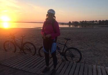
Tour Wandern von 19 km verfügbar auf Neu-Aquitanien, Gironde, Hourtin. Diese Tour wird von ffffff vorgeschlagen.
Beschreibung
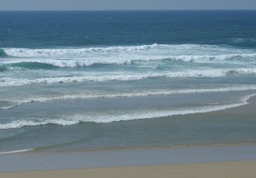
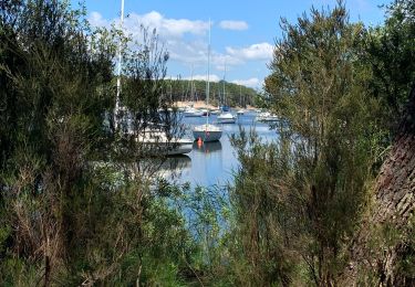
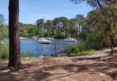
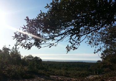
boucle de 19,3 km en 4 heures longeant la plage sur 5 km (sur sable plus compacté, en marée descendante) et retour par chemins forestiers ... de dunes (= un peu plus fatiguant)
Ort
Land:
France
Region :
Neu-Aquitanien
Abteilung/Provinz :
Gironde
Kommune :
Hourtin
Standort:
Unknown
Gehen Sie:(Dec)
Gehen Sie:(UTM)
647458 ; 5006728 (30T) N.
Kommentare
Touren in der Umgebung
![Tour Zu Fuß Hourtin - Voie de Soulac - Photo](https://media.geolcdn.com/t/375/260/ext.jpg?maxdim=2&url=https%3A%2F%2Fmedia.geolcdn.com%2Ff%2F6e8b8ee2-ca9a-41d4-86c1-6920ccddc8e8.jpeg)
![Zu Fuß Zu Fuß](https://static1.geolcdn.com/sitytour/trail-icons/100.png)
Voie de Soulac
Zu Fuß
Sehr schwierig
Hourtin,
Neu-Aquitanien,
Gironde,
France
![](/images/other/stat-length.png)
40 km | 43 km-effort
9h 50min
![](https://static1.geolcdn.com/siteimages/upload/files/16400158638029165_repeat_loop_refresh_sync_direction_icon.png)
Nein
![Tour Wandern Hourtin - Fonfon/zot/sylvia piqueyrot la gracieuse AR - Photo](https://media.geolcdn.com/t/375/260/ext.jpg?maxdim=2&url=https%3A%2F%2Fmedia.geolcdn.com%2Ff%2Fc4d671e2-0c94-4bce-810b-718ec585a4c8.jpg)
![Wandern Wandern](https://static1.geolcdn.com/sitytour/trail-icons/101.png)
Fonfon/zot/sylvia piqueyrot la gracieuse AR
Wandern
Hourtin,
Neu-Aquitanien,
Gironde,
France
![](/images/other/stat-length.png)
15,2 km | 18,1 km-effort
3h 44min
![](https://static1.geolcdn.com/siteimages/upload/files/16400158638029165_repeat_loop_refresh_sync_direction_icon.png)
Ja
![Tour Wandern Hourtin - Piqueyrot - Photo](https://media.geolcdn.com/t/375/260/ext.jpg?maxdim=2&url=https%3A%2F%2Fmedia.geolcdn.com%2Ff%2F0ad03336-e011-4519-bf37-1a571ca73fb3.jpg)
![Wandern Wandern](https://static1.geolcdn.com/sitytour/trail-icons/101.png)
![Tour Wandern Hourtin - lac de hourtin - Photo](https://media.geolcdn.com/t/375/260/ext.jpg?maxdim=2&url=https%3A%2F%2Fmedia.geolcdn.com%2Ff%2F13a97ea5-2621-46c5-b66c-c47741074de7.jpg)
![Wandern Wandern](https://static1.geolcdn.com/sitytour/trail-icons/101.png)
lac de hourtin
Wandern
Sehr leicht
Hourtin,
Neu-Aquitanien,
Gironde,
France
![](/images/other/stat-length.png)
3,8 km | 4,3 km-effort
1h 29min
![](https://static1.geolcdn.com/siteimages/upload/files/16400158638029165_repeat_loop_refresh_sync_direction_icon.png)
Ja
![Tour Wandern Hourtin - Contaut b - Photo](https://media.geolcdn.com/t/375/260/ext.jpg?maxdim=2&url=https%3A%2F%2Fservices.sitytrail.com%2FGeolivesWS%2FDownloadMedia.ashx%3FTrailID%3D894713%26Media%3Dfix__20180127161006.jpg)
![Wandern Wandern](https://static1.geolcdn.com/sitytour/trail-icons/101.png)
Contaut b
Wandern
Medium
Hourtin,
Neu-Aquitanien,
Gironde,
France
![](/images/other/stat-length.png)
8,8 km | 10,8 km-effort
2h 54min
![](https://static1.geolcdn.com/siteimages/upload/files/16400158638029165_repeat_loop_refresh_sync_direction_icon.png)
Ja
![Tour Andere Aktivitäten Hourtin - hourtin port- ocean-piste et cingle - Photo](https://media.geolcdn.com/t/375/260/ext.jpg?maxdim=2&url=https%3A%2F%2Fservices.sitytrail.com%2FGeolivesWS%2FDownloadMedia.ashx%3FTrailID%3D700529%26Media%3D20170218182213.jpg)
![Andere Aktivitäten Andere Aktivitäten](https://static1.geolcdn.com/sitytour/trail-icons/900.png)
hourtin port- ocean-piste et cingle
Andere Aktivitäten
Einfach
Hourtin,
Neu-Aquitanien,
Gironde,
France
![](/images/other/stat-length.png)
45 km | 51 km-effort
5h 12min
![](https://static1.geolcdn.com/siteimages/upload/files/16400158638029165_repeat_loop_refresh_sync_direction_icon.png)
Ja
![Tour Wandern Hourtin - rando hourtin biches - Photo](https://media.geolcdn.com/t/375/260/ext.jpg?maxdim=2&url=https%3A%2F%2Fmedia.geolcdn.com%2Ff%2F87b581c9-84ae-4b90-bb81-ba384e3c1402.jpg)
![Wandern Wandern](https://static1.geolcdn.com/sitytour/trail-icons/101.png)
rando hourtin biches
Wandern
Einfach
Hourtin,
Neu-Aquitanien,
Gironde,
France
![](/images/other/stat-length.png)
4,5 km | 4,8 km-effort
1h 6min
![](https://static1.geolcdn.com/siteimages/upload/files/16400158638029165_repeat_loop_refresh_sync_direction_icon.png)
Nein
![Tour Hybrid-Bike Hourtin - Carcan - Photo](https://media.geolcdn.com/t/375/260/ext.jpg?maxdim=2&url=https%3A%2F%2Fstatic1.geolcdn.com%2Fsiteimages%2Fupload%2Ffiles%2F1524743154velo.jpg)
![Hybrid-Bike Hybrid-Bike](https://static1.geolcdn.com/sitytour/trail-icons/203.png)
![Tour Hybrid-Bike Hourtin - Hourtin plage - Photo](https://media.geolcdn.com/t/375/260/ext.jpg?maxdim=2&url=https%3A%2F%2Fstatic1.geolcdn.com%2Fsiteimages%2Fupload%2Ffiles%2F1524743154velo.jpg)
![Hybrid-Bike Hybrid-Bike](https://static1.geolcdn.com/sitytour/trail-icons/203.png)
Hourtin plage
Hybrid-Bike
Medium
Hourtin,
Neu-Aquitanien,
Gironde,
France
![](/images/other/stat-length.png)
24 km | 27 km-effort
1h 35min
![](https://static1.geolcdn.com/siteimages/upload/files/16400158638029165_repeat_loop_refresh_sync_direction_icon.png)
Nein