


Oderen - autour du Gommkopf - Chemin de Laffe- Strasshisel

patrickbeyrath
Utente


3h05
Difficoltà : Difficile

Applicazione GPS da escursionismo GRATUITA
 SityTrail
IGN / Istituti geografici
SityTrail Plus
Il mondo è tuo
Chi siamo
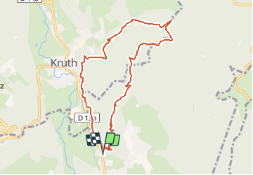
Percorso Marcia di 9,2 km da scoprire a Grande Est, Haut-Rhin, Oderen. Questo percorso è proposto da patrickbeyrath.
Descrizione
Parking arboriculteurs, rue de Vontay - triangle bleu Uhufels - Pfaffenkopf - triangle jaune Gommkopf - Chemin de Laffe puis rectangle rouge blanc rouge Holtzplatz aller direction Laffe et prendre à gauche indication Strasshisel et aller juste à l'abri et prendre le retour le long de Kruth- Oderen-
Localizzazione
Commenti