Trail Walking Mortrée - Les deux Rivières - Le pays de Mortrée - Photo

Les deux Rivières - Le pays de Mortrée

 tracegps
tracegps

User

© OpenStreetMap contributors
Length
Length
14.4 km
Max alt
Max alt
199 m
Uphill gradient
Uphill gradient
109 m
Km-Effort
Km-Effort  
15.8 km
Min alt
Min alt
167 m
Downhill gradient
Downhill gradient
109 m
Boucle
Boucle
Yes
Creation date :
2014-12-10 00:00:00.0
Updated on :
2014-12-10 00:00:00.0

(2 Reviews)

Walking
Walking
2h34
Difficulty : Medium

Scan this QR Code to open this trail in the SityTrail application

FREE GPS app for hiking

Logo SityTrail SityTrail

IGN / Geographical institutes

Download SityTrail from the App Store Download SityTrail from Google Play

Logo SityTrail SityTrail World

The world is yours!

Download SityTrail from the App Store Download SityTrail from Google Play Download SityTrail on Huawei AppGallery

About

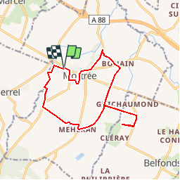
Trail Walking of 14.4 km to be discovered at Normandy, Orne, Mortrée. This trail is proposed by tracegps.

Description

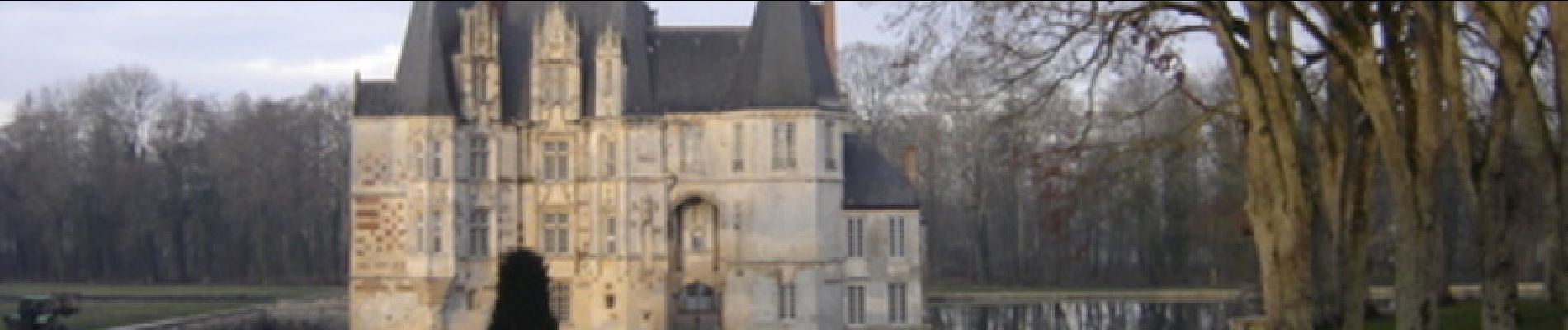
Les deux Rivières - Le pays de Mortrée. Départ : de Mortrée, derrière l’église « Saint Pierre et Saint Paul » de style néo-grec à l’imposant clocher campanile. La commune de Mortrée est née de la fusion des anciennes paroisses d’O, de Bray et de Marigny par un décret du 6 thermidor an II (1794) (balisage jaune). Retrouvez les Coup de Cœur Randonnée dans l’Orne en Normandie.

Elevation profile

Photos

Positioning

Country:
France
Region :
Normandy
Department/Province :
Orne
Municipality :
Mortrée
Location:
Mortrée
Start:(UTM)
284190 ; 5391784 (31U) N.

Comments

Please log in to post a review or rate the element


Trails nearby

Trail Mountain bike Mortrée - Au fil des chemins en Ecouves - Mortrée - Balisage n°7 - Photo
Mountain bike
tracegps

Mountain bike

Medium
(1)
Mortrée, Normandy, Orne, France
31 km | 36 km-effort
2h 30min
Yes
Trail Walking Mortrée - St Hilaire la Gerard - Photo
Walking
HUBERTClaude

Walking

Difficult
Mortrée, Normandy, Orne, France
11.3 km | 13.2 km-effort
2h 31min
Yes
Trail Mountain bike Médavy - VTT - Medavy - Photo
Mountain bike
yannick-p

Mountain bike

Medium
Médavy, Normandy, Orne, France
19.8 km | 22 km-effort
1h 30min
Yes
Trail Mountain bike Mortrée - Mortrée - Sées - Mortrée - Photo
Mountain bike
yannick-p

Mountain bike

Easy
Mortrée, Normandy, Orne, France
40 km | 44 km-effort
2h 58min
Yes
Trail Running Mortrée - Parcours footing 6 - Photo
Running
yannick-p

Running

Easy
Mortrée, Normandy, Orne, France
10.1 km | 11.4 km-effort
45min
Yes
Trail Mountain bike Mortrée - Mortree VTT 1 - Variante - Photo
Mountain bike
yannick-p

Mountain bike

Medium
Mortrée, Normandy, Orne, France
22 km | 27 km-effort
1h 46min
Yes
Trail Walking Médavy - Médavy - Almeneches (Boucle) - Photo
Walking
neitag61

Walking

Medium
Médavy, Normandy, Orne, France
19.7 km | 22 km-effort
4h 48min
Yes
Trail Running Mortrée - Parcours footing 4 - Photo
Running
yannick-p

Running

Easy
Mortrée, Normandy, Orne, France
9.6 km | 10.7 km-effort
1h 27min
Yes
Trail Walking Le Cercueil - Le CERCUEIL - Photo
Walking
HUBERTClaude

Walking

Difficult
Le Cercueil, Normandy, Orne, France
11.5 km | 14.3 km-effort
2h 37min
Yes


Close
My subscriptions