Trail Walking Saint-Cyprien - SAINT-CYPRIEN SUD 66 - Le bocal du TECH  - Photo

SAINT-CYPRIEN SUD 66 - Le bocal du TECH

 jeff66
jeff66

User

© OpenStreetMap contributors
Length
Length
6.5 km
Max alt
Max alt
6 m
Uphill gradient
Uphill gradient
17 m
Km-Effort
Km-Effort  
6.8 km
Min alt
Min alt
-2 m
Downhill gradient
Downhill gradient
17 m
Boucle
Boucle
Yes
Creation date :
2015-06-15 00:00:00.0
Updated on :
2015-06-15 00:00:00.0

(1 Reviews)

Walking
Walking
1h20
Difficulty : Easy

Scan this QR Code to open this trail in the SityTrail application

FREE GPS app for hiking

Logo SityTrail SityTrail

IGN / Geographical institutes

Download SityTrail from the App Store Download SityTrail from Google Play

Logo SityTrail SityTrail World

The world is yours!

Download SityTrail from the App Store Download SityTrail from Google Play Download SityTrail on Huawei AppGallery

About

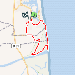
Trail Walking of 6.5 km to be discovered at Occitania, Pyrénées-Orientales, Saint-Cyprien. This trail is proposed by jeff66.

Description

SAINT-CYPRIEN SUD 66 - plage de la lagune - Cala Gogo - résidence le village de la mer, hameau du rivage, les frégates, l'anse des capellans - plage de petits galets et sables -  vue sur la côte vermeille - Le bocal du TECH - forêt alluviale - le TECH - îlot du TECH - bocal du TECH - mas Bertrand - la vigia - résidence les jardins d'harmonia et les embruns - pas d'en Ferrer - colomine d'en Roca -parc d'attractions aquatique AQUALAND - résidence les reflets

Elevation profile

Photos

Positioning

Country:
France
Region :
Occitania
Department/Province :
Pyrénées-Orientales
Municipality :
Saint-Cyprien
Location:
Unknown
Start:(UTM)
502802 ; 4716657 (31T) N.

Comments

Please log in to post a review or rate the element


Trails nearby

Trail Walking Saint-Cyprien - SAINT-CYPRIEN 66 - front de mer - les CAPELLANS - Photo
Walking
jeff66

Walking

Easy
(2)
Saint-Cyprien, Occitania, Pyrénées-Orientales, France
9.9 km | 10.3 km-effort
2h 11min
Yes
Trail Equestrian Saint-Cyprien - bocal du Tech - Photo
Equestrian
sandymocko

Equestrian

Medium
(1)
Saint-Cyprien, Occitania, Pyrénées-Orientales, France
17 km | 17.7 km-effort
3h 20min
Yes
Trail Walking Argelès-sur-Mer - 2018-01-31 ARGELES PLAGE - Photo
Walking
rousseau.mich

Walking

Very easy
(1)
Argelès-sur-Mer, Occitania, Pyrénées-Orientales, France
7.5 km | 8.1 km-effort
2h 34min
Yes
Trail Walking Argelès-sur-Mer - 66 ARGELES SUR MER, place et port, par le sentier littoral et retour par allée du RACOU - Photo
Walking
jeff66

Walking

Easy
Argelès-sur-Mer, Occitania, Pyrénées-Orientales, France
6.4 km | 6.9 km-effort
1h 11min
Yes
Trail Walking Argelès-sur-Mer - 66 TAXO D'AVALL, voie piétonne de TAXO À LA MER, ARGELES-PLAGE puis ARGELES SUR MER - Photo
Walking
jeff66

Walking

Medium
Argelès-sur-Mer, Occitania, Pyrénées-Orientales, France
8.4 km | 9 km-effort
1h 18min
Yes
Trail Walking Saint-Cyprien - 66 SAINT-CYPRIEN - ALENYA - LATOUR-BAS-ELNE - de berges en berges  - Photo
Walking
jeff66

Walking

Medium
Saint-Cyprien, Occitania, Pyrénées-Orientales, France
7.9 km | 8.3 km-effort
1h 16min
Yes
Trail Walking Argelès-sur-Mer - MAS LARRIEU - ARGELES-SUR-MER 66 - autour de la réserve naturelle, le littoral et retour par l'embouchure du TECH - Photo
Walking
jeff66

Walking

Medium
(1)
Argelès-sur-Mer, Occitania, Pyrénées-Orientales, France
13.6 km | 14.3 km-effort
2h 24min
Yes
Trail Walking Elne - ALENYA 66 - entre l'Agouille de la Mar et le Réart - Photo
Walking
jeff66

Walking

Easy
Elne, Occitania, Pyrénées-Orientales, France
12.6 km | 13.1 km-effort
1h 57min
Yes
Trail Walking Argelès-sur-Mer - mas larrieu - argeles / l hiver - Photo
Walking
stef789

Walking

Medium
Argelès-sur-Mer, Occitania, Pyrénées-Orientales, France
8.7 km | 9.1 km-effort
2h 17min
Yes


Close
My subscriptions