Trail Walking Château-Ville-Vieille - le Sommet du Bucher - Photo
 margotte
margotte

User

© OpenStreetMap contributors
Length
Length
14.6 km
Max alt
Max alt
2236 m
Uphill gradient
Uphill gradient
932 m
Km-Effort
Km-Effort  
27 km
Min alt
Min alt
1343 m
Downhill gradient
Downhill gradient
928 m
Boucle
Boucle
Yes
Creation date :
2019-06-11 14:16:08.481
Updated on :
2020-04-26 15:29:52.216

(0 Reviews)

Walking
Walking
5h27
Difficulty : Difficult

Scan this QR Code to open this trail in the SityTrail application

FREE GPS app for hiking

Logo SityTrail SityTrail

IGN / Geographical institutes

Download SityTrail from the App Store Download SityTrail from Google Play

Logo SityTrail SityTrail World

The world is yours!

Download SityTrail from the App Store Download SityTrail from Google Play Download SityTrail on Huawei AppGallery

About

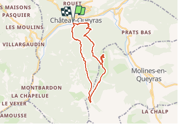
Trail Walking of 14.6 km to be discovered at Provence-Alpes-Côte d'Azur, Hautes-Alpes, Château-Ville-Vieille. This trail is proposed by margotte.

Description

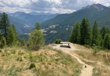
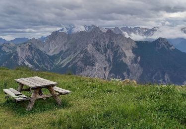
le sommet est à la hauteur de l'effort: vue à 360° sur les sommets avec tables d'orientation et banc pour se poser. Par contre déception ...3 voitures avaient emprunté la piste ce qui gâche un peu le plaisir de la marche mais pourquoi pas!! .La montée le long du torrent de Bramousse est sauvage et avec de splendides orchidées.la descente par le sentier trés raide et peu ou pas balisé est à déconseiller aux personnes sujettes au vertige, angoissées, aux jeunes enfants ... ,par contre prendre le sentier bien balisé qui mène à Ville-Vieille et longer le Guil pour revenir à Château-Queyras est plus sécurisant.

Elevation profile

Photos

Positioning

Country:
France
Region :
Provence-Alpes-Côte d'Azur
Department/Province :
Hautes-Alpes
Municipality :
Château-Ville-Vieille
Location:
Unknown
Start:(UTM)
325275 ; 4958243 (32T) N.

Trails nearby

Trail Walking Château-Ville-Vieille - Queyras j1 - Photo
Walking
Ninie38MD

Walking

Medium
(1)
Château-Ville-Vieille, Provence-Alpes-Côte d'Azur, Hautes-Alpes, France
19.1 km | 36 km-effort
8h 6min
No
Trail Mountain bike Château-Ville-Vieille - Tour du Queyras - Photo
Mountain bike
tracegps

Mountain bike

Very difficult
(1)
Château-Ville-Vieille, Provence-Alpes-Côte d'Azur, Hautes-Alpes, France
32 km | 50 km-effort
3h 0min
Yes
Trail Walking Arvieux - les alpages de Furfande - Photo
Walking
GUIDE
amiral13

Walking

Easy
Arvieux, Provence-Alpes-Côte d'Azur, Hautes-Alpes, France
17 km | 29 km-effort
6h 57min
Yes
Trail Walking Château-Ville-Vieille - Ville-vieille - Ceillac - Photo
Walking
GUIDE
romanceline

Walking

Medium
Château-Ville-Vieille, Provence-Alpes-Côte d'Azur, Hautes-Alpes, France
17.4 km | 31 km-effort
6h 51min
No
Trail Snowshoes Arvieux - Arvieux- Col de Furfande - Photo
Snowshoes
meunier.ph.

Snowshoes

Easy
Arvieux, Provence-Alpes-Côte d'Azur, Hautes-Alpes, France
12.9 km | 26 km-effort
4h 6min
Yes
Trail Walking Arvieux - Lac de Roue variante  - Photo
Walking
rochedaniel

Walking

Difficult
Arvieux, Provence-Alpes-Côte d'Azur, Hautes-Alpes, France
9.5 km | 14.6 km-effort
3h 34min
Yes
Trail Walking Arvieux - arvieux en boucle par furfande ( col et chalets) - Photo
Walking
tchoua

Walking

Easy
Arvieux, Provence-Alpes-Côte d'Azur, Hautes-Alpes, France
21 km | 38 km-effort
4h 40min
Yes
Trail Walking Château-Ville-Vieille - 05-pointe-du-Rasis-13km-760m-aout21 - Photo
Walking
SyMA

Walking

Difficult
Château-Ville-Vieille, Provence-Alpes-Côte d'Azur, Hautes-Alpes, France
13.2 km | 23 km-effort
5h 32min
Yes
Trail Walking Arvieux - Furfande - Photo
Walking
CAUBERTGENEVIEVE

Walking

Medium
Arvieux, Provence-Alpes-Côte d'Azur, Hautes-Alpes, France
12.6 km | 22 km-effort
7h 14min
No


Close
My subscriptions