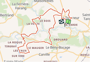
19,7 km | 26 km-effort
rando de la souleuvre
mikeleguerrier
Utilisateur
Longueur
25 km
Altitude max
210 m
Dénivelé positif
522 m
Km-Effort
32 km
Altitude min
72 m
Dénivelé négatif
522 m
Boucle
Oui
Date de création :
2018-04-17 23:23:24.439
Dernière modification :
2018-04-17 23:23:24.439
2h07
Difficulté : Moyen
Application GPS de randonnée GRATUITE
À propos
Randonnée V.T.T. de 25 km à découvrir à Normandie, Calvados, Souleuvre-en-Bocage. Cette randonnée est proposée par mikeleguerrier.
Description
Des bons coups de cul avec les cailloux, la boue et tout et tout
Localisation
Pays :
France
Région :
Normandie
Département/Province :
Calvados
Commune :
Souleuvre-en-Bocage
Localité :
Le Tourneur
Départ:(Dec)
Départ:(UTM)
658888 ; 5424790 (30U) N.
Commentaires
Randonnées à proximité
SAINT PIERRE TARENTAINE
Marche
Très difficile
(1)
Souleuvre-en-Bocage,
Normandie,
Calvados,
France
5h 47min
Oui
La vire
Marche
Moyen
Souleuvre-en-Bocage,
Normandie,
Calvados,
France
22 km | 28 km-effort
5h 0min
Oui
carville
Marche
Facile
Souleuvre-en-Bocage,
Normandie,
Calvados,
France
7,7 km | 9,8 km-effort
1h 49min
Oui
Vélomaritime Cherbourg Caen #J6 20210710 Le Bény-Bocage - Baron-sur-Odon
Cyclotourisme
Très facile
Souleuvre-en-Bocage,
Normandie,
Calvados,
France
64 km | 75 km-effort
Inconnu
Non
le beny bocage
Marche
Très facile
Souleuvre-en-Bocage,
Normandie,
Calvados,
France
3,6 km | 5,2 km-effort
2h 2min
Non
LaVallée de la Souleuvre
Marche
Moyen
Souleuvre-en-Bocage,
Normandie,
Calvados,
France
7,2 km | 9,8 km-effort
2h 5min
Oui
11 - St Denis La Ferrière harang Vire
Cyclotourisme
Moyen
Souleuvre-en-Bocage,
Normandie,
Calvados,
France
18,2 km | 21 km-effort
Inconnu
Non
Autour du pont de la Souleuvre
Marche
Facile
Souleuvre-en-Bocage,
Normandie,
Calvados,
France
14,2 km | 18,2 km-effort
3h 11min
Oui
C'était trop bon!