![](/images/other/stat-length.png)
- Touren
- Zu Fuß
- France
- Auvergne-Rhone-Alpen
- Isère
- La Balme-les-Grottes
La Balme-les-Grottes, Isère, Zu Fuß: Die besten Touren, Trails, Trecks und Wanderungen
1 kommentare
La Balme-les-Grottes : Entdecken Sie die besten Touren : 3 wandern und 1 laufen. Alle diese Touren, Trails, Routen und Outdoor-Aktivitäten sind in unseren SityTrail-Apps für Smartphones und Tablets verfügbar.
Die besten Spuren (4)
![Tour Wandern La Balme-les-Grottes - la balme vertrieu - Photo](https://media.geolcdn.com/t/350/260/ext.jpg?maxdim=2&url=https%3A%2F%2Fservices.sitytrail.com%2FGeolivesWS%2FDownloadMedia.ashx%3FTrailID%3D845518%26Media%3D20171014170646.jpg)
![Wandern Wandern](https://static1.geolcdn.com/sitytour/trail-icons/101.png)
Km
#1 - la balme vertrieu
Wandern
Sehr leicht
(1)
La Balme-les-Grottes,
Auvergne-Rhone-Alpen,
Isère,
France
![](/images/other/stat-length.png)
8,6 km | 11,7 km-effort
3h 19min
![](https://static1.geolcdn.com/siteimages/upload/files/1508320355ic_sort_den_pos_24dp.png)
235 m
![](https://static1.geolcdn.com/siteimages/upload/files/1508320355ic_sort_den_neg_24dp.png)
234 m
![](https://static1.geolcdn.com/siteimages/upload/files/16400158638029165_repeat_loop_refresh_sync_direction_icon.png)
Nein
montalet
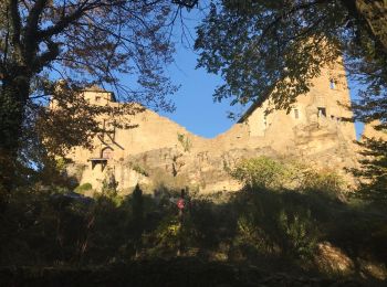
• depart la balme les grottes et arrivee Vertrieu chateau vieux
![Tour Wandern La Balme-les-Grottes - La Balme les Grottes et alentours - Photo](https://media.geolcdn.com/t/350/260/ext.jpg?maxdim=2&url=https%3A%2F%2Fservices.sitytrail.com%2FGeolivesWS%2FDownloadMedia.ashx%3FTrailID%3D191608%26Media%3D15249_4.jpg)
![Wandern Wandern](https://static1.geolcdn.com/sitytour/trail-icons/101.png)
Km
#2 - La Balme les Grottes et alentours
Wandern
Medium
La Balme-les-Grottes,
Auvergne-Rhone-Alpen,
Isère,
France
![](/images/other/stat-length.png)
2,8 km | 4,9 km-effort
1h 30min
![](https://static1.geolcdn.com/siteimages/upload/files/1508320355ic_sort_den_pos_24dp.png)
158 m
![](https://static1.geolcdn.com/siteimages/upload/files/1508320355ic_sort_den_neg_24dp.png)
161 m
![](https://static1.geolcdn.com/siteimages/upload/files/16400158638029165_repeat_loop_refresh_sync_direction_icon.png)
Ja
tracegps
![Tour Wandern La Balme-les-Grottes - 38 la balme les grottes - Photo](https://media.geolcdn.com/t/350/260/ext.jpg?maxdim=2&url=https%3A%2F%2Fstatic1.geolcdn.com%2Fsiteimages%2Fupload%2Ffiles%2F1553511878bg_sport_marche.png)
![Wandern Wandern](https://static1.geolcdn.com/sitytour/trail-icons/101.png)
Km
#3 - 38 la balme les grottes
Wandern
Medium
La Balme-les-Grottes,
Auvergne-Rhone-Alpen,
Isère,
France
![](/images/other/stat-length.png)
10 km | 13,4 km-effort
3h 0min
![](https://static1.geolcdn.com/siteimages/upload/files/1508320355ic_sort_den_pos_24dp.png)
252 m
![](https://static1.geolcdn.com/siteimages/upload/files/1508320355ic_sort_den_neg_24dp.png)
254 m
![](https://static1.geolcdn.com/siteimages/upload/files/16400158638029165_repeat_loop_refresh_sync_direction_icon.png)
Ja
trietsch
![Tour Laufen La Balme-les-Grottes - 2011-09-11 11h19m28 - Photo](https://media.geolcdn.com/t/350/260/ext.jpg?maxdim=2&url=https%3A%2F%2Fstatic1.geolcdn.com%2Fsiteimages%2Fupload%2Ffiles%2F1524743154running.jpg)
![Laufen Laufen](https://static1.geolcdn.com/sitytour/trail-icons/103.png)
Km
#4 - 2011-09-11 11h19m28
Laufen
Einfach
La Balme-les-Grottes,
Auvergne-Rhone-Alpen,
Isère,
France
![](/images/other/stat-length.png)
5,3 km | 5,8 km-effort
Unbekannt
![](https://static1.geolcdn.com/siteimages/upload/files/1508320355ic_sort_den_pos_24dp.png)
42 m
![](https://static1.geolcdn.com/siteimages/upload/files/1508320355ic_sort_den_neg_24dp.png)
42 m
![](https://static1.geolcdn.com/siteimages/upload/files/16400158638029165_repeat_loop_refresh_sync_direction_icon.png)
Ja
wattlar
4 Angezeigte Touren bei 4
Kostenlosegpshiking-Anwendung