![](/images/other/stat-length.png)
- Touren
- Outdoor
- Austria
- Tirol
- Bezirk Schwaz
- Gemeinde Gerlos
Gemeinde Gerlos, Bezirk Schwaz: Die besten Touren, Trails, Trecks und Wanderungen
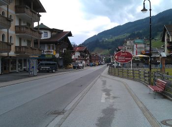
Gemeinde Gerlos : Entdecken Sie die besten Touren : 12 zu Fuß. Alle diese Touren, Trails, Routen und Outdoor-Aktivitäten sind in unseren SityTrail-Apps für Smartphones und Tablets verfügbar.
Die besten Spuren (12)
![Tour Zu Fuß Gemeinde Gerlos - Wasserfall-Trail - Photo](https://media.geolcdn.com/t/350/260/ext.jpg?maxdim=2&url=https%3A%2F%2Fmedia.geolcdn.com%2Ff%2F9f60ade8-b829-49f6-a230-4db6b4604c2c.jpeg)
![Zu Fuß Zu Fuß](https://static1.geolcdn.com/sitytour/trail-icons/100.png)
Km
Zu Fuß
![](/images/other/stat-length.png)
![](https://static1.geolcdn.com/siteimages/upload/files/1508320355ic_sort_den_pos_24dp.png)
![](https://static1.geolcdn.com/siteimages/upload/files/1508320355ic_sort_den_neg_24dp.png)
![](https://static1.geolcdn.com/siteimages/upload/files/16400158638029165_repeat_loop_refresh_sync_direction_icon.png)
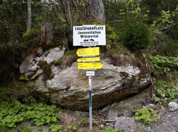
• Trail created by Gerlos. Symbol: Gelbe Blechschilder mit schwarzem Richtungspfeil und blauem, unteren Rand
![Tour Zu Fuß Gemeinde Gerlos - Wanderweg 7a - Gerlos - Photo](https://media.geolcdn.com/t/350/260/ext.jpg?maxdim=2&url=https%3A%2F%2Fmedia.geolcdn.com%2Ff%2Fe1afe855-32ad-4494-8d21-68f75dd359af.jpeg)
![Zu Fuß Zu Fuß](https://static1.geolcdn.com/sitytour/trail-icons/100.png)
Km
Zu Fuß
![](/images/other/stat-length.png)
![](https://static1.geolcdn.com/siteimages/upload/files/1508320355ic_sort_den_pos_24dp.png)
![](https://static1.geolcdn.com/siteimages/upload/files/1508320355ic_sort_den_neg_24dp.png)
![](https://static1.geolcdn.com/siteimages/upload/files/16400158638029165_repeat_loop_refresh_sync_direction_icon.png)
• Trail created by TVB Gerlos. Symbol: Gelbe Wegweisschilder mit schwarzer Schrift
![Tour Zu Fuß Gemeinde Gerlos - Wanderweg 4 - Gerlos - Photo](https://media.geolcdn.com/t/350/260/ext.jpg?maxdim=2&url=https%3A%2F%2Fmedia.geolcdn.com%2Ff%2Ff0fbe92e-5b0f-48d8-90ce-de9f38e1cbd5.jpeg)
![Zu Fuß Zu Fuß](https://static1.geolcdn.com/sitytour/trail-icons/100.png)
Km
Zu Fuß
![](/images/other/stat-length.png)
![](https://static1.geolcdn.com/siteimages/upload/files/1508320355ic_sort_den_pos_24dp.png)
![](https://static1.geolcdn.com/siteimages/upload/files/1508320355ic_sort_den_neg_24dp.png)
![](https://static1.geolcdn.com/siteimages/upload/files/16400158638029165_repeat_loop_refresh_sync_direction_icon.png)
• Trail created by TVB Zell-Gerlos. Symbol: Gelbe Wegweisschilder mit schwarzer Schrift
![Tour Zu Fuß Gemeinde Gerlos - Innertal-Runde - Photo](https://media.geolcdn.com/t/350/260/ext.jpg?maxdim=2&url=https%3A%2F%2Fmedia.geolcdn.com%2Ff%2F70c476f7-e8d3-4b76-a1cb-9a4ae4ca99a5.jpeg)
![Zu Fuß Zu Fuß](https://static1.geolcdn.com/sitytour/trail-icons/100.png)
Km
Zu Fuß
![](/images/other/stat-length.png)
![](https://static1.geolcdn.com/siteimages/upload/files/1508320355ic_sort_den_pos_24dp.png)
![](https://static1.geolcdn.com/siteimages/upload/files/1508320355ic_sort_den_neg_24dp.png)
![](https://static1.geolcdn.com/siteimages/upload/files/16400158638029165_repeat_loop_refresh_sync_direction_icon.png)
• Trail created by Gerlos. Symbol: Gelbe Blechschilder mit rotem Richtungspfeil und grünem, unteren Rand
![Tour Zu Fuß Gemeinde Gerlos - Gmündner Seemeile - Photo](https://media.geolcdn.com/t/350/260/ext.jpg?maxdim=2&url=https%3A%2F%2Fmedia.geolcdn.com%2Ff%2F52cba597-4e8b-4777-af27-bb3644f93dd2.jpeg)
![Zu Fuß Zu Fuß](https://static1.geolcdn.com/sitytour/trail-icons/100.png)
Km
Zu Fuß
![](/images/other/stat-length.png)
![](https://static1.geolcdn.com/siteimages/upload/files/1508320355ic_sort_den_pos_24dp.png)
![](https://static1.geolcdn.com/siteimages/upload/files/1508320355ic_sort_den_neg_24dp.png)
![](https://static1.geolcdn.com/siteimages/upload/files/16400158638029165_repeat_loop_refresh_sync_direction_icon.png)
• Trail created by Gerlos. Symbol: Gelbe Blechschilder mit blauem Richtungspfeil und violettem, unteren Rand
![Tour Zu Fuß Gemeinde Gerlos - Bachrunde - Photo](https://media.geolcdn.com/t/350/260/ext.jpg?maxdim=2&url=https%3A%2F%2Fstatic1.geolcdn.com%2Fsiteimages%2Fupload%2Ffiles%2F1545311037marcheuse_200dpi.jpg)
![Zu Fuß Zu Fuß](https://static1.geolcdn.com/sitytour/trail-icons/100.png)
Km
Zu Fuß
![](/images/other/stat-length.png)
![](https://static1.geolcdn.com/siteimages/upload/files/1508320355ic_sort_den_pos_24dp.png)
![](https://static1.geolcdn.com/siteimages/upload/files/1508320355ic_sort_den_neg_24dp.png)
![](https://static1.geolcdn.com/siteimages/upload/files/16400158638029165_repeat_loop_refresh_sync_direction_icon.png)
• Trail created by Gerlos. Symbol: Gelbe Blechschilder mit rotem Richtungspfeil und hellblauem, unteren Rand
![Tour Zu Fuß Gemeinde Gerlos - Wanderweg 7 - Gerlos - Photo](https://media.geolcdn.com/t/350/260/ext.jpg?maxdim=2&url=https%3A%2F%2Fstatic1.geolcdn.com%2Fsiteimages%2Fupload%2Ffiles%2F1545311037marcheuse_200dpi.jpg)
![Zu Fuß Zu Fuß](https://static1.geolcdn.com/sitytour/trail-icons/100.png)
Km
Zu Fuß
![](/images/other/stat-length.png)
![](https://static1.geolcdn.com/siteimages/upload/files/1508320355ic_sort_den_pos_24dp.png)
![](https://static1.geolcdn.com/siteimages/upload/files/1508320355ic_sort_den_neg_24dp.png)
![](https://static1.geolcdn.com/siteimages/upload/files/16400158638029165_repeat_loop_refresh_sync_direction_icon.png)
• Trail created by TVB Zell-Gerlos. Symbol: Gelbe Wegweisschilder mit schwarzer Schrift
![Tour Zu Fuß Gemeinde Gerlos - Wanderweg 5 - Gerlos - Photo](https://media.geolcdn.com/t/350/260/ext.jpg?maxdim=2&url=https%3A%2F%2Fstatic1.geolcdn.com%2Fsiteimages%2Fupload%2Ffiles%2F1545311037marcheuse_200dpi.jpg)
![Zu Fuß Zu Fuß](https://static1.geolcdn.com/sitytour/trail-icons/100.png)
Km
Zu Fuß
![](/images/other/stat-length.png)
![](https://static1.geolcdn.com/siteimages/upload/files/1508320355ic_sort_den_pos_24dp.png)
![](https://static1.geolcdn.com/siteimages/upload/files/1508320355ic_sort_den_neg_24dp.png)
![](https://static1.geolcdn.com/siteimages/upload/files/16400158638029165_repeat_loop_refresh_sync_direction_icon.png)
• Trail created by TVB Gerlos. Symbol: Gelbe Wegweisschilder mit schwarzer Schrift
![Tour Wandern Gemeinde Gerlos - Bergliebe - Photo](https://media.geolcdn.com/t/350/260/ext.jpg?maxdim=2&url=https%3A%2F%2Fstatic1.geolcdn.com%2Fsiteimages%2Fupload%2Ffiles%2F1553511878bg_sport_marche.png)
![Wandern Wandern](https://static1.geolcdn.com/sitytour/trail-icons/101.png)
Km
Wandern
![](/images/other/stat-length.png)
![](https://static1.geolcdn.com/siteimages/upload/files/1508320355ic_sort_den_pos_24dp.png)
![](https://static1.geolcdn.com/siteimages/upload/files/1508320355ic_sort_den_neg_24dp.png)
![](https://static1.geolcdn.com/siteimages/upload/files/16400158638029165_repeat_loop_refresh_sync_direction_icon.png)
![Tour Wandern Gemeinde Gerlos - Arbiskogel - Photo](https://media.geolcdn.com/t/350/260/ext.jpg?maxdim=2&url=https%3A%2F%2Fstatic1.geolcdn.com%2Fsiteimages%2Fupload%2Ffiles%2F1553511878bg_sport_marche.png)
![Wandern Wandern](https://static1.geolcdn.com/sitytour/trail-icons/101.png)
Km
Wandern
![](/images/other/stat-length.png)
![](https://static1.geolcdn.com/siteimages/upload/files/1508320355ic_sort_den_pos_24dp.png)
![](https://static1.geolcdn.com/siteimages/upload/files/1508320355ic_sort_den_neg_24dp.png)
![](https://static1.geolcdn.com/siteimages/upload/files/16400158638029165_repeat_loop_refresh_sync_direction_icon.png)
![Tour Wandern Gemeinde Gerlos - Schonbichl - Photo](https://media.geolcdn.com/t/350/260/ext.jpg?maxdim=2&url=https%3A%2F%2Fstatic1.geolcdn.com%2Fsiteimages%2Fupload%2Ffiles%2F1553511878bg_sport_marche.png)
![Wandern Wandern](https://static1.geolcdn.com/sitytour/trail-icons/101.png)
Km
Wandern
![](/images/other/stat-length.png)
![](https://static1.geolcdn.com/siteimages/upload/files/1508320355ic_sort_den_pos_24dp.png)
![](https://static1.geolcdn.com/siteimages/upload/files/1508320355ic_sort_den_neg_24dp.png)
![](https://static1.geolcdn.com/siteimages/upload/files/16400158638029165_repeat_loop_refresh_sync_direction_icon.png)
![Tour Wandern Gemeinde Gerlos - Kreuzkogel 2552m - Photo](https://media.geolcdn.com/t/350/260/ext.jpg?maxdim=2&url=https%3A%2F%2Fstatic1.geolcdn.com%2Fsiteimages%2Fupload%2Ffiles%2F1553511878bg_sport_marche.png)
![Wandern Wandern](https://static1.geolcdn.com/sitytour/trail-icons/101.png)
Km
Wandern
![](/images/other/stat-length.png)
![](https://static1.geolcdn.com/siteimages/upload/files/1508320355ic_sort_den_pos_24dp.png)
![](https://static1.geolcdn.com/siteimages/upload/files/1508320355ic_sort_den_neg_24dp.png)
![](https://static1.geolcdn.com/siteimages/upload/files/16400158638029165_repeat_loop_refresh_sync_direction_icon.png)
12 Angezeigte Touren bei 12
Kostenlosegpshiking-Anwendung