Startseite
World
NEW
Premium
Speichern Sie
Touren
Artikel
Hilfe - Unterstützung
Français
English
Nederlands
Español
Italiano
Deutsch
Verbindung
Startseite
World
Premium
Speichern Sie
Touren
Artikel
Hilfe - Unterstützung
SityTrail
>
POIs
>
GC122ZB
SityTrail
>
POIs
>
GC122ZB
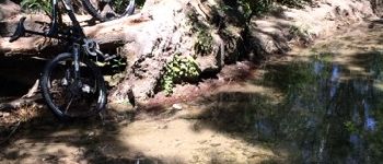
GC122ZB
Beschreibung
UCHAUX "Le Castelas" by PAPY8
Foto-Galerie
Erkunden Sie GC122ZB mit den folgenden Touren...
tracegps
Col du Souffre et Lacs Mont-Coua
Wandern
Schwierig
(1)
Les Allues, Auvergne-Rhone-Alpen, Savoyen, France
25 km | 41 km-effort
7h 0min
Ja
tracegps
Benutzer
©
OpenStreetMap
contributors
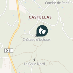
Ort
Land:
France
Region :
Provence-Alpes-Côte d'Azur
Abteilung/Provinz :
Vaucluse
Kommune :
Uchaux
Standort:
Unknown
Ort
44.218116961 / 4.803716987
Erstellungsdatum :
2018-04-09 12:22:48.788
Letzte Änderung
2018-04-09 12:22:48.788
(0 Nachricht)
Kommentare
Bitte melden Sie sich an, um einen Kommentar oder eine Bewertung zu hinterlassen
POI's in der Nähe
tracegps
GC122ZB
UCHAUX
mapomme
cassant rivière
UCHAUX
mapomme
traversée de gué
UCHAUX
tracegps
GC12JNK
UCHAUX
tracegps
GC12JNK
UCHAUX
mapomme
départ single ?
ROCHEGUDE
mapomme
croisement single
ROCHEGUDE
tracegps
GC1230C
SÉRIGNAN-DU-COMTAT
Schließen
Meine Abonnements