Startseite
World
NEW
Premium
Speichern Sie
Touren
Artikel
Hilfe - Unterstützung
Français
English
Nederlands
Español
Italiano
Deutsch
Verbindung
Startseite
World
Premium
Speichern Sie
Touren
Artikel
Hilfe - Unterstützung
SityTrail
>
POIs
>
GCN4EW
SityTrail
>
POIs
>
GCN4EW
GCN4EW
Beschreibung
Long slope by norpan, back, an
Foto-Galerie
Erkunden Sie GCN4EW mit den folgenden Touren...
tracegps
Col du Souffre et Lacs Mont-Coua
Wandern
Schwierig
(1)
Les Allues, Auvergne-Rhone-Alpen, Savoyen, France
25 km | 41 km-effort
7h 0min
Ja
tracegps
Benutzer
©
OpenStreetMap
contributors
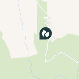
Ort
Land:
France
Region :
Auvergne-Rhone-Alpen
Abteilung/Provinz :
Isère
Kommune :
Le Freney-d'Oisans
Standort:
Unknown
Ort
45.090967035 / 6.126867039
Erstellungsdatum :
2018-04-09 12:22:12.584
Letzte Änderung
2018-04-09 12:22:12.584
(0 Nachricht)
Kommentare
Bitte melden Sie sich an, um einen Kommentar oder eine Bewertung zu hinterlassen
POI's in der Nähe
tracegps
GCN4EW
LE FRENEY-D'OISANS
tracegps
GCN4EW
LE FRENEY-D'OISANS
tracegps
GCN4EW
LE FRENEY-D'OISANS
tracegps
GCN4EW
LE FRENEY-D'OISANS
tracegps
GCN4EW
LE FRENEY-D'OISANS
JCottard
Quitter à droite
LE FRENEY-D'OISANS
fel
Point 2
HUEZ
tracegps
GCN194
HUEZ
Schließen
Meine Abonnements