Startseite
World
NEW
Premium
Speichern Sie
Touren
Artikel
Hilfe - Unterstützung
Français
English
Nederlands
Español
Italiano
Deutsch
Verbindung
Startseite
World
Premium
Speichern Sie
Touren
Artikel
Hilfe - Unterstützung
SityTrail
>
POIs
>
GC17EVR
SityTrail
>
POIs
>
GC17EVR
GC17EVR
Beschreibung
Le sentier du fer by vilcanota
Foto-Galerie
Erkunden Sie GC17EVR mit den folgenden Touren...
tracegps
Dent du Villard depuis La Rosière
Wandern
Schwierig
(1)
Courchevel, Auvergne-Rhone-Alpen, Savoyen, France
9,4 km | 19,2 km-effort
6h 0min
Ja
tracegps
Benutzer
©
OpenStreetMap
contributors
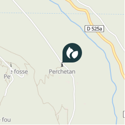
Ort
Land:
France
Region :
Auvergne-Rhone-Alpen
Abteilung/Provinz :
Isère
Kommune :
Le Haut-Bréda
Standort:
Pinsot
Ort
45.373767 / 6.091017
Erstellungsdatum :
2018-04-09 12:17:48.4
Letzte Änderung
2018-04-09 12:17:48.4
(0 Nachricht)
Kommentare
Bitte melden Sie sich an, um einen Kommentar oder eine Bewertung zu hinterlassen
POI's in der Nähe
tracegps
GC17EVR
LE HAUT-BRÉDA
tracegps
GC17EVR
LE HAUT-BRÉDA
tracegps
GC17EVR
LE HAUT-BRÉDA
tracegps
GC17EVR
LE HAUT-BRÉDA
tracegps
GC17EVR
LE HAUT-BRÉDA
tracegps
GC17EVR
LE HAUT-BRÉDA
tracegps
GC17EVR
LE HAUT-BRÉDA
tracegps
GC17EVR
LE HAUT-BRÉDA
Schließen
Meine Abonnements