Startseite
World
NEW
Premium
Speichern Sie
Touren
Artikel
Hilfe - Unterstützung
Français
English
Nederlands
Español
Italiano
Deutsch
Verbindung
Startseite
World
Premium
Speichern Sie
Touren
Artikel
Hilfe - Unterstützung
SityTrail
>
POIs
>
GC1FQM9
SityTrail
>
POIs
>
GC1FQM9
GC1FQM9
Beschreibung
La rivière d'Ain by Jul&Fab, U
Foto-Galerie
Erkunden Sie GC1FQM9 mit den folgenden Touren...
tracegps
Mont-Jovet depuis La Cour
Wandern
Schwierig
(1)
Bozel, Auvergne-Rhone-Alpen, Savoyen, France
13,5 km | 27 km-effort
6h 0min
Ja
tracegps
Benutzer
©
OpenStreetMap
contributors
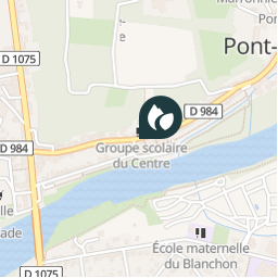
Ort
Land:
France
Region :
Auvergne-Rhone-Alpen
Abteilung/Provinz :
Ain
Kommune :
Pont-d'Ain
Standort:
Unknown
Ort
46.049433 / 5.3401
Erstellungsdatum :
2018-04-09 12:20:27.362
Letzte Änderung
2018-04-09 12:20:27.362
(0 Nachricht)
Kommentare
Bitte melden Sie sich an, um einen Kommentar oder eine Bewertung zu hinterlassen
POI's in der Nähe
tracegps
GC1FQM9
PONT-D'AIN
tracegps
GC1FQM9
PONT-D'AIN
tracegps
GC1FQM9
PONT-D'AIN
tracegps
GC1FQM9
PONT-D'AIN
tracegps
GC1FQM9
PONT-D'AIN
tracegps
GC1FQM9
PONT-D'AIN
tracegps
GC1FQM9
PONT-D'AIN
gpstracks
START-12
AMBRONAY
Schließen
Meine Abonnements