Startseite
World
NEW
Premium
Speichern Sie
Touren
Artikel
Hilfe - Unterstützung
Français
English
Nederlands
Español
Italiano
Deutsch
Verbindung
Startseite
World
Premium
Speichern Sie
Touren
Artikel
Hilfe - Unterstützung
SityTrail
>
POIs
>
GCVR32
SityTrail
>
POIs
>
GCVR32
GCVR32
Beschreibung
LA FORÊT DE BLAIRE WITCH by jo
Foto-Galerie
Erkunden Sie GCVR32 mit den folgenden Touren...
tracegps
Mont-Jovet depuis La Cour
Wandern
Schwierig
(1)
Bozel, Auvergne-Rhone-Alpen, Savoyen, France
13,5 km | 27 km-effort
6h 0min
Ja
tracegps
Benutzer
©
OpenStreetMap
contributors
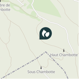
Ort
Land:
France
Region :
Auvergne-Rhone-Alpen
Abteilung/Provinz :
Savoyen
Kommune :
Entrelacs
Standort:
Saint-Germain-la-Chambotte
Ort
45.76855 / 5.880267
Erstellungsdatum :
2018-04-09 12:21:43.867
Letzte Änderung
2018-04-09 12:21:43.867
(0 Nachricht)
Kommentare
Bitte melden Sie sich an, um einen Kommentar oder eine Bewertung zu hinterlassen
POI's in der Nähe
tracegps
GCVR32
ENTRELACS
tracegps
GCVR32
ENTRELACS
tracegps
GCVR32
ENTRELACS
tracegps
GCVR32
ENTRELACS
tracegps
GCVR32
ENTRELACS
tracegps
GCVR32
ENTRELACS
tracegps
GCVR32
ENTRELACS
tracegps
GCVR32
ENTRELACS
Schließen
Meine Abonnements