Startseite
World
NEW
Premium
Speichern Sie
Touren
Artikel
Hilfe - Unterstützung
Français
English
Nederlands
Español
Italiano
Deutsch
Verbindung
Startseite
World
Premium
Speichern Sie
Touren
Artikel
Hilfe - Unterstützung
SityTrail
>
POIs
>
GC143AZ
SityTrail
>
POIs
>
GC143AZ
GC143AZ
Beschreibung
Montclus-Serres-l'Epine by Mir
Foto-Galerie
Erkunden Sie GC143AZ mit den folgenden Touren...
tracegps
Sentiers des Pointières
Wandern
Medium
Queige, Auvergne-Rhone-Alpen, Savoyen, France
6,8 km | 11,3 km-effort
3h 30min
Ja
tracegps
Benutzer
©
OpenStreetMap
contributors
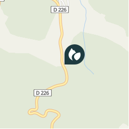
Ort
Land:
France
Region :
Provence-Alpes-Côte d'Azur
Abteilung/Provinz :
Hochalpen
Kommune :
L'Épine
Standort:
Unknown
Ort
44.40705 / 5.612217
Erstellungsdatum :
2018-04-09 12:16:30.9
Letzte Änderung
2018-04-09 12:16:30.9
(0 Nachricht)
Kommentare
Bitte melden Sie sich an, um einen Kommentar oder eine Bewertung zu hinterlassen
POI's in der Nähe
tracegps
GC143AZ
L'ÉPINE
tracegps
GC143AZ
L'ÉPINE
tracegps
GC143AZ
L'ÉPINE
tracegps
GC143AZ
L'ÉPINE
tracegps
GC143AZ
L'ÉPINE
CampingLesRivesduLac
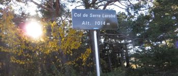
Serre Larobe
L'ÉPINE
CampingLesRivesduLac
Montée sur le Devès
MONTJAY
CampingLesRivesduLac
Vers Vaucluse haute
MONTJAY
Schließen
Meine Abonnements