Startseite
World
NEW
Premium
Speichern Sie
Touren
Artikel
Hilfe - Unterstützung
Français
English
Nederlands
Español
Italiano
Deutsch
Verbindung
Startseite
World
Premium
Speichern Sie
Touren
Artikel
Hilfe - Unterstützung
SityTrail
>
POIs
>
GCYY9H
SityTrail
>
POIs
>
GCYY9H
GCYY9H
Beschreibung
Aqueduc romain du Gier N2 by
Foto-Galerie
Erkunden Sie GCYY9H mit den folgenden Touren...
tracegps
Sentiers des Pointières
Wandern
Medium
Queige, Auvergne-Rhone-Alpen, Savoyen, France
6,8 km | 11,3 km-effort
3h 30min
Ja
tracegps
Benutzer
©
OpenStreetMap
contributors
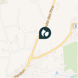
Ort
Land:
France
Region :
Auvergne-Rhone-Alpen
Abteilung/Provinz :
Rhône
Kommune :
Chaponost
Standort:
Unknown
Ort
45.7228 / 4.761
Erstellungsdatum :
2018-04-09 12:18:21.518
Letzte Änderung
2018-04-09 12:18:21.518
(0 Nachricht)
Kommentare
Bitte melden Sie sich an, um einen Kommentar oder eine Bewertung zu hinterlassen
POI's in der Nähe
tracegps
GCYY9H
CHAPONOST
tracegps
GCYY9H
CHAPONOST
tracegps
GCYY9H
CHAPONOST
tracegps
GCYY9H
CHAPONOST
tracegps
GCYY9H
CHAPONOST
tracegps
GCYY9H
CHAPONOST
tracegps
GCYY9H
CHAPONOST
tracegps
GCYY9H
CHAPONOST
Schließen
Meine Abonnements