Startseite
World
NEW
Premium
Speichern Sie
Touren
Artikel
Hilfe - Unterstützung
Français
English
Nederlands
Español
Italiano
Deutsch
Verbindung
Startseite
World
Premium
Speichern Sie
Touren
Artikel
Hilfe - Unterstützung
SityTrail
>
POIs
>
GCKHB2
SityTrail
>
POIs
>
GCKHB2
GCKHB2
Beschreibung
Le chemin creux de Montchaboud
Foto-Galerie
Erkunden Sie GCKHB2 mit den folgenden Touren...
tracegps
Le Lac du Lou
Wandern
Medium
(2)
Les Belleville, Auvergne-Rhone-Alpen, Savoyen, France
7,4 km | 12 km-effort
3h 0min
Ja
tracegps
Benutzer
©
OpenStreetMap
contributors
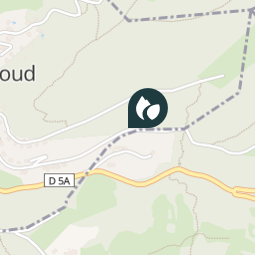
Ort
Land:
France
Region :
Auvergne-Rhone-Alpen
Abteilung/Provinz :
Isère
Kommune :
Montchaboud
Standort:
Unknown
Ort
45.093633 / 5.772067
Erstellungsdatum :
2018-04-09 12:15:48.553
Letzte Änderung
2018-04-09 12:15:48.553
(0 Nachricht)
Kommentare
Bitte melden Sie sich an, um einen Kommentar oder eine Bewertung zu hinterlassen
POI's in der Nähe
tracegps
GCKHB2
MONTCHABOUD
tracegps
GCKHB2
MONTCHABOUD
tracegps
GCKHB2
MONTCHABOUD
tracegps
GCKHB2
MONTCHABOUD
tracegps
GCKHB2
MONTCHABOUD
tracegps
GCKHB2
MONTCHABOUD
tracegps
GCKHB2
MONTCHABOUD
tracegps
GCKHB2
MONTCHABOUD
Schließen
Meine Abonnements