Startseite
World
NEW
Premium
Speichern Sie
Touren
Artikel
Hilfe - Unterstützung
Français
English
Nederlands
Español
Italiano
Deutsch
Verbindung
Startseite
World
Premium
Speichern Sie
Touren
Artikel
Hilfe - Unterstützung
SityTrail
>
POIs
>
GCGG3M
SityTrail
>
POIs
>
GCGG3M
GCGG3M
Beschreibung
Col de Saix by Bertrand, Tradi
Foto-Galerie
Erkunden Sie GCGG3M mit den folgenden Touren...
tracegps
Crêt Coquet
Wandern
Medium
(3)
Hautecour, Auvergne-Rhone-Alpen, Savoyen, France
6,5 km | 9,6 km-effort
3h 30min
Ja
tracegps
Benutzer
©
OpenStreetMap
contributors
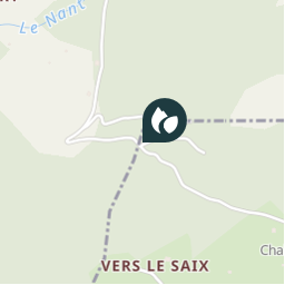
Ort
Land:
France
Region :
Auvergne-Rhone-Alpen
Abteilung/Provinz :
Hochsavoyen
Kommune :
Châtel
Standort:
Unknown
Ort
46.28855 / 6.830283
Erstellungsdatum :
2018-04-09 12:18:02.535
Letzte Änderung
2018-04-09 12:18:02.535
(0 Nachricht)
Kommentare
Bitte melden Sie sich an, um einen Kommentar oder eine Bewertung zu hinterlassen
POI's in der Nähe
tracegps
GCGG3M
CHÂTEL
tracegps
GCGG3M
CHÂTEL
tracegps
GCGG3M
CHÂTEL
tracegps
GCGG3M
CHÂTEL
tracegps
GCGG3M
CHÂTEL
tracegps
GCGG3M
CHÂTEL
tracegps
GCGG3M
CHÂTEL
tracegps
GCGG3M
CHÂTEL
Schließen
Meine Abonnements