Startseite
World
NEW
Premium
Speichern Sie
Touren
Artikel
Hilfe - Unterstützung
Français
English
Nederlands
Español
Italiano
Deutsch
Verbindung
Startseite
World
Premium
Speichern Sie
Touren
Artikel
Hilfe - Unterstützung
SityTrail
>
POIs
>
départ
SityTrail
>
POIs
>
départ
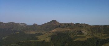
départ
Beschreibung
05-AOU-09 17:49:36
Foto-Galerie
Erkunden Sie départ mit den folgenden Touren...
tracegps
le Peyre Arse - Le Lioran
Wandern
Schwierig
(1)
Laveissière, Auvergne-Rhone-Alpen, Cantal, France
11,2 km | 19,4 km-effort
4h 0min
Nein
tracegps
Benutzer
©
OpenStreetMap
contributors
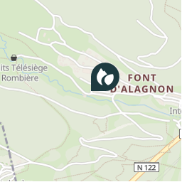
Ort
Land:
France
Region :
Auvergne-Rhone-Alpen
Abteilung/Provinz :
Cantal
Kommune :
Laveissière
Standort:
Unknown
Ort
45.0884803 / 2.7379915
Erstellungsdatum :
2018-04-09 12:09:33.339
Letzte Änderung
2018-04-09 12:09:33.339
(0 Nachricht)
Kommentare
Bitte melden Sie sich an, um einen Kommentar oder eine Bewertung zu hinterlassen
POI's in der Nähe
tracegps
Depart Le Lioran
LAVEISSIÈRE
tracegps
Depart Le Lioran
LAVEISSIÈRE
tracegps
Arrivee Le Lioran
LAVEISSIÈRE
tracegps
Arrivee Le Lioran
LAVEISSIÈRE
zefreefly
Rocher du bec de l'aigle
LAVEISSIÈRE
zefreefly
Têton de Venus 1669
LAVEISSIÈRE
zefreefly
Bivouac 1
MANDAILLES-SAINT-JULIEN
alapeyronnie
puy Mary vue du Griou
SAINT-JACQUES-DES-BLATS
Schließen
Meine Abonnements