![](/images/other/stat-length.png)
![Tour Mountainbike Bogève - La Vallée Verte - Photo](https://media.geolcdn.com/t/1900/400/ext.pjpeg?maxdim=2&url=https%3A%2F%2Fstatic1.geolcdn.com%2Fsiteimages%2Fupload%2Ffiles%2F1524743154velo.jpg)
La Vallée Verte
tracegps
Benutzer
![Länge](/images/other/stat-length.png)
![Maximale Höhe](https://static1.geolcdn.com/siteimages/upload/files/1508320355ic_sort_altitude_max_24dp.png)
![Positive Höhendifferenz](https://static1.geolcdn.com/siteimages/upload/files/1508320355ic_sort_den_pos_24dp.png)
![Km-Effort](/images/other/stat-length.png)
![Min. Höhe](https://static1.geolcdn.com/siteimages/upload/files/1508320355ic_sort_altitude_min_24dp.png)
![Negative Höhendifferenz](https://static1.geolcdn.com/siteimages/upload/files/1508320355ic_sort_den_neg_24dp.png)
![Boucle](https://static1.geolcdn.com/siteimages/upload/files/16400158638029165_repeat_loop_refresh_sync_direction_icon.png)
![Mountainbike](https://static1.geolcdn.com/sitytour/trail-icons/202.png)
4h00
Schwierigkeit : Sehr schwierig
![Scannen Sie diesen QR-Code, um die Tour in der SityTrail-Anwendung zu öffnen](https://capi.geolives.com/qq0zvz2zws4bq2lad0pu/sitytour/trails/100638/qr.png?size=200)
Kostenlosegpshiking-Anwendung
Über SityTrail
Tour Mountainbike von 25 km verfügbar auf Auvergne-Rhone-Alpen, Hochsavoyen, Bogève. Diese Tour wird von tracegps vorgeschlagen.
Beschreibung
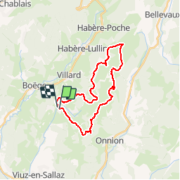
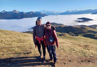
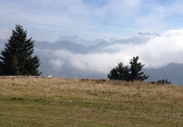
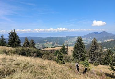
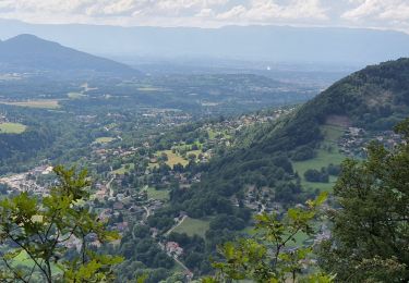
Circuit en boucle à partir de Bogève avec montée sur le plateau de Plaine-Joux et les crêtes d'Hirmentaz. Les premières montées étant relativement raides, il est judicieux de les aborder après un minimum d'échauffement. Montée de Bogève à Plaine-Joux puis l'itinéraire serpente sur le plateau de Plaine-Joux avant d'aborder la montée au col du Creux puis sur les crêtes d'Hirmentaz (petite station de ski). Depuis l'arrivée du télésiège, descendre par une piste peu marquée dans les alpages et rejoindre le GRP "Tour de la Vallée Verte". On rejoint ensuite Bogève en traversant plusieurs hameaux. Le départ s'effectue à Bogève, au carrefour situé au centre du village - Coordonnées : N 46° 11' 35.3" - E 006° 25' 46.7" Altitude : 931 m. Bogève est situé à 25 km d'Annemasse et à 26 km de Bonneville. La difficulté du parcours proposé est due davantage au dénivelé relativement important (1350 m sur 27 km) qu'à la nature du parcours qui va du chemin relativement large au sentier monotrace avec un court passage dans les alpages sans trace bien marquée. Un peu de poussage au-dessus du col du Creux et à l'arrivée sur les crêtes d'Hirmentaz. L'itinéraire permet la découverte d'une vallée qui mérite bien son nom : la Vallée Verte et offre une vue panoramique sur de nombreux sommets environnants. Praticabilité : en année normale : de mai à novembre. En cas d'enneigement exceptionnel, des névés relativement importants peuvent subsister début mai.
Ort
Kommentare
Touren in der Umgebung
![Tour Wandern Viuz-en-Sallaz - Viuz-Les Brasses-Vernant-Viuz - Photo](https://media.geolcdn.com/t/375/260/ext.jpg?maxdim=2&url=https%3A%2F%2Fmedia.geolcdn.com%2Ff%2F34dcd57e-15ca-4ca3-ab02-fc2bad27ee19.jpg)
![Wandern Wandern](https://static1.geolcdn.com/sitytour/trail-icons/101.png)
Wandern
![](/images/other/stat-length.png)
![](https://static1.geolcdn.com/siteimages/upload/files/16400158638029165_repeat_loop_refresh_sync_direction_icon.png)
![Tour Wandern Onnion - Tour de la vallée de Miribel - Photo](https://media.geolcdn.com/t/375/260/ext.jpg?maxdim=2&url=https%3A%2F%2Fstatic1.geolcdn.com%2Fsiteimages%2Fupload%2Ffiles%2F1553511878bg_sport_marche.png)
![Wandern Wandern](https://static1.geolcdn.com/sitytour/trail-icons/101.png)
Wandern
![](/images/other/stat-length.png)
![](https://static1.geolcdn.com/siteimages/upload/files/16400158638029165_repeat_loop_refresh_sync_direction_icon.png)
![Tour Wandern Onnion - la pointe de miribelle - Photo](https://media.geolcdn.com/t/375/260/ext.jpg?maxdim=2&url=https%3A%2F%2Fmedia.geolcdn.com%2Ff%2Ff20e3184-1b4e-419f-9856-9f36a9a88049.jpg)
![Wandern Wandern](https://static1.geolcdn.com/sitytour/trail-icons/101.png)
Wandern
![](/images/other/stat-length.png)
![](https://static1.geolcdn.com/siteimages/upload/files/16400158638029165_repeat_loop_refresh_sync_direction_icon.png)
![Tour Wandern Habère-Lullin - Crêts des Brottets et d'Hirmentaz - Photo](https://media.geolcdn.com/t/375/260/ext.jpg?maxdim=2&url=https%3A%2F%2Fservices.sitytrail.com%2FGeolivesWS%2FDownloadMedia.ashx%3FTrailID%3D476346%26Media%3D20150926123411.jpg)
![Wandern Wandern](https://static1.geolcdn.com/sitytour/trail-icons/101.png)
Wandern
![](/images/other/stat-length.png)
![](https://static1.geolcdn.com/siteimages/upload/files/16400158638029165_repeat_loop_refresh_sync_direction_icon.png)
![Tour Wandern Onnion - la pointe de meribel - Photo](https://media.geolcdn.com/t/375/260/ext.jpg?maxdim=2&url=https%3A%2F%2Fmedia.geolcdn.com%2Ff%2Fc3f02bbe-a87b-403b-a623-5e0d5729f248.jpg)
![Wandern Wandern](https://static1.geolcdn.com/sitytour/trail-icons/101.png)
Wandern
![](/images/other/stat-length.png)
![](https://static1.geolcdn.com/siteimages/upload/files/16400158638029165_repeat_loop_refresh_sync_direction_icon.png)
![Tour Wandern Saint-André-de-Boëge - 2021.09.24 Molière - Photo](https://media.geolcdn.com/t/375/260/ext.jpg?maxdim=2&url=https%3A%2F%2Fmedia.geolcdn.com%2Ff%2F00b5061b-5e1e-472a-9057-8d523759e272.jpg)
![Wandern Wandern](https://static1.geolcdn.com/sitytour/trail-icons/101.png)
Wandern
![](/images/other/stat-length.png)
![](https://static1.geolcdn.com/siteimages/upload/files/16400158638029165_repeat_loop_refresh_sync_direction_icon.png)
![Tour Wandern Viuz-en-Sallaz - Boisinges - Crêtes de Vouan_25.07.2021 - Photo](https://media.geolcdn.com/t/375/260/ext.jpg?maxdim=2&url=https%3A%2F%2Fmedia.geolcdn.com%2Ff%2F63e31eaa-4938-4cc2-88e4-e3de10ed1069.jpg)
![Wandern Wandern](https://static1.geolcdn.com/sitytour/trail-icons/101.png)
Wandern
![](/images/other/stat-length.png)
![](https://static1.geolcdn.com/siteimages/upload/files/16400158638029165_repeat_loop_refresh_sync_direction_icon.png)
![Tour Mountainbike Onnion - VTT(74)-N°9 - Tour d'Hirmentaz - 28 km 1065 m+ - Photo](https://media.geolcdn.com/t/375/260/ext.jpg?maxdim=2&url=https%3A%2F%2Fmedia.geolcdn.com%2Ff%2F12ecc564-da95-41c9-a8fe-81f81f650c48.jpg)
![Mountainbike Mountainbike](https://static1.geolcdn.com/sitytour/trail-icons/202.png)
Mountainbike
![](/images/other/stat-length.png)
![](https://static1.geolcdn.com/siteimages/upload/files/16400158638029165_repeat_loop_refresh_sync_direction_icon.png)
![Tour Wandern Habère-Lullin - Reco rando G3 La crête Mirmentaz 16-05 - Photo](https://media.geolcdn.com/t/375/260/ext.jpg?maxdim=2&url=https%3A%2F%2Fservices.sitytrail.com%2FGeolivesWS%2FDownloadMedia.ashx%3FTrailID%3D969003%26Media%3Dfix__20180516151822.jpg)
![Wandern Wandern](https://static1.geolcdn.com/sitytour/trail-icons/101.png)
Wandern
![](/images/other/stat-length.png)
![](https://static1.geolcdn.com/siteimages/upload/files/16400158638029165_repeat_loop_refresh_sync_direction_icon.png)