Tour Fahrrad Sault - Montagne de Lure - Photo
 tracegps
tracegps

Benutzer

© OpenStreetMap contributors
Länge
Länge
133 km
Maximale Höhe
Maximale Höhe
1749 m
Positive Höhendifferenz
2893 m
Km-Effort
Km-Effort  
172 km
Min. Höhe
Min. Höhe
506 m
Negative Höhendifferenz
2893 m
Boucle
Boucle
Ja
Erstellungsdatum :
2014-12-10 00:00:00.0
Letzte Änderung :
2014-12-10 00:00:00.0

(0 Nachricht)

Fahrrad
Fahrrad
6h00
Schwierigkeit : Schwierig

Scannen Sie diesen QR-Code, um die Tour in der SityTrail-Anwendung zu öffnen

Kostenlosegpshiking-Anwendung

Logo SityTrail SityTrail

IGN / Geografische Institute

SityTrail aus dem App Store herunterladen SityTrail von Google Play herunterladen

Logo SityTrail SityTrail World

Die Welt öffnet sich für Sie

SityTrail aus dem App Store herunterladen SityTrail von Google Play herunterladen SityTrail auf Huawei AppGallery herunterladen

Über SityTrail

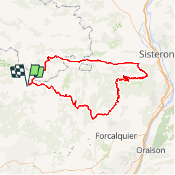
Tour Fahrrad von 133 km verfügbar auf Provence-Alpes-Côte d'Azur, Vaucluse, Sault. Diese Tour wird von tracegps vorgeschlagen.

Beschreibung

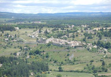
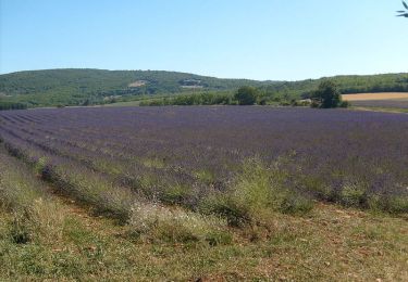
Boucle départ Sault direction Banon, St Etienne les Orgues, montée de la montagne Lure 1° moitié dure passage pas de la Graille descente sur la vallée du Jabron, Montfroc , col de Macuègne et col de l'homme mort, retour sur Sault.

Höhenprofil

POIs

POI Vichy - 1 etape Vichy - Photo
tracegps
POI Charavines - charavines - Photo
tracegps
CHARAVINES 
POI Chirens - Chirens - Photo
tracegps
CHIRENS 
POI Merlas - Col 1000 marty - Photo
tracegps
POI Coublevie - Croix Bayard - Photo
tracegps
COUBLEVIE 
POI Saint-Geoire-en-Valdaine - D82 - Photo
tracegps
SAINT-GEOIRE-EN-VALDAINE 
POI Engins - engins1 - Photo
tracegps
ENGINS 
POI Voreppe - Fin piste - Photo
tracegps
VOREPPE 
POI Lans-en-Vercors - jaume - Photo
tracegps
LANS-EN-VERCORS 
POI Voreppe - mille martyrs - Photo
tracegps
VOREPPE 
POI Miribel-les-Échelles - Miribel - Photo
tracegps
MIRIBEL-LES-ÉCHELLES 
POI Montferrat - Montferrat - Photo
tracegps
MONTFERRAT 
POI Sassenage - piedmontee - Photo
tracegps
SASSENAGE 
POI Saint-Laurent-du-Pont - St laurent G - Photo
tracegps
SAINT-LAURENT-DU-PONT 
POI Grenoble - vercors et dio - Photo
tracegps
GRENOBLE 
POI Villard-de-Lans - villard 1 - Photo
tracegps
VILLARD-DE-LANS 

Ort

Land:
France
Region :
Provence-Alpes-Côte d'Azur
Abteilung/Provinz :
Vaucluse
Kommune :
Sault
Standort:
Unknown
Gehen Sie:(Dec)
Gehen Sie:(UTM)
694022 ; 4886113 (31T) N.

Touren in der Umgebung

Tour Wandern Sault - Sault - Le plateau d'Albion - Photo
Wandern
Drailloun

Wandern

Einfach
(1)
Sault, Provence-Alpes-Côte d'Azur, Vaucluse, France
12,6 km | 16,5 km-effort
3h 25min
Ja
Tour Wandern Sault - sault, saint trinit, aurel, sault - Photo
Wandern
FLORENSAC

Wandern

Medium
Sault, Provence-Alpes-Côte d'Azur, Vaucluse, France
17,1 km | 21 km-effort
6h 45min
Ja
Tour Zu Fuß Sault - Le chemin des lavandes - Photo
Zu Fuß
PRO

Zu Fuß

Einfach
Sault, Provence-Alpes-Côte d'Azur, Vaucluse, France
5 km | 6 km-effort
1h 21min
Nein
Tour Mountainbike Aurel - GTVAU-J4-Long - Photo
Mountainbike
PhilippeC54

Mountainbike

Sehr schwierig
(1)
Aurel, Provence-Alpes-Côte d'Azur, Vaucluse, France
68 km | 89 km-effort
6h 9min
Nein
Tour Wandern Aurel - PF-Aurel - Le Ventouret  - Photo
Wandern
MicDul

Wandern

Einfach
Aurel, Provence-Alpes-Côte d'Azur, Vaucluse, France
12,3 km | 19,1 km-effort
3h 56min
Ja
Tour Mountainbike Sault - Entre Sault et la Tour de Durefort - Photo
Mountainbike
tracegps

Mountainbike

Medium
Sault, Provence-Alpes-Côte d'Azur, Vaucluse, France
15,1 km | 20 km-effort
1h 30min
Ja
Tour Wandern Sault - Entre Sault et la Tour de Durefort - Photo
Wandern
tracegps

Wandern

Medium
Sault, Provence-Alpes-Côte d'Azur, Vaucluse, France
15,1 km | 20 km-effort
4h 0min
Ja
Tour Fahrrad Sault - Circuit Vélo -  Le Plateau d'Albion - Sault - Photo
Fahrrad
tracegps

Fahrrad

Medium
Sault, Provence-Alpes-Côte d'Azur, Vaucluse, France
32 km | 39 km-effort
2h 30min
Ja
Tour Rennrad Sault - Mombrun les thermes le Negron photos - Photo
Rennrad
Daniel6952

Rennrad

Sehr schwierig
Sault, Provence-Alpes-Côte d'Azur, Vaucluse, France
68 km | 85 km-effort
4h 16min
Ja


Schließen
Meine Abonnements