Tour Mountainbike Vire Normandie - Rando VTT de Roullours - 2010 - Photo

Rando VTT de Roullours - 2010

 tracegps
tracegps

Benutzer

© OpenStreetMap contributors
Länge
Länge
36 km
Maximale Höhe
Maximale Höhe
310 m
Positive Höhendifferenz
600 m
Km-Effort
Km-Effort  
44 km
Min. Höhe
Min. Höhe
125 m
Negative Höhendifferenz
600 m
Boucle
Boucle
Ja
Erstellungsdatum :
2014-12-10 00:00:00.0
Letzte Änderung :
2014-12-10 00:00:00.0

(2 Nachricht)

Mountainbike
Mountainbike
2h15
Schwierigkeit : Medium

Scannen Sie diesen QR-Code, um die Tour in der SityTrail-Anwendung zu öffnen

Kostenlosegpshiking-Anwendung

Logo SityTrail SityTrail

IGN / Geografische Institute

SityTrail aus dem App Store herunterladen SityTrail von Google Play herunterladen

Logo SityTrail SityTrail World

Die Welt öffnet sich für Sie

SityTrail aus dem App Store herunterladen SityTrail von Google Play herunterladen SityTrail auf Huawei AppGallery herunterladen

Über SityTrail

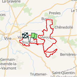
Tour Mountainbike von 36 km verfügbar auf Normandie, Calvados, Vire Normandie. Diese Tour wird von tracegps vorgeschlagen.

Beschreibung

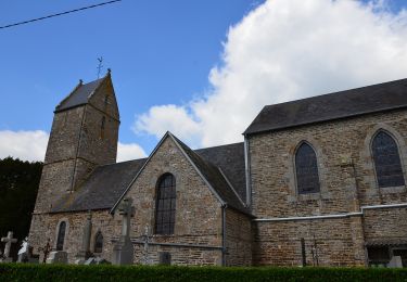
Randonnée vtt organisée à Roullours le 11 avril 2010, empruntant de nombreux chemins communaux dont ceux récemment ouverts près de Roullours. Parcours assez vallonné, qui permet de découvrir les paysages de la Basse Normandie, entre une succession de fermes et de champs. Certaines portions sont assez engagées, notamment avec une montée assez raide au départ d'un chemin qui se fait dans une ornière; et une descente dont la fin se fait dans la caillasse. Certains passages demandent un peu de technique, dont un qui est particulièrement glissant (descente avec un ruisseau au milieu du chemin). A privilégier au Printemps et Eté, car le reste de l'année les chemins sont particulièrement boueux en général.

Höhenprofil

Ort

Land:
France
Region :
Normandie
Abteilung/Provinz :
Calvados
Kommune :
Vire Normandie
Standort:
Roullours
Gehen Sie:(Dec)
Gehen Sie:(UTM)
658625 ; 5411074 (30U) N.

Kommentare

Bitte melden Sie sich an, um einen Kommentar oder eine Bewertung zu hinterlassen


Je n'ai pas encore essayé, quelqu'un pourrait me dire si il y a des vrais chemins ou si ce n'est que de la voie verte.Merci


Touren in der Umgebung

Tour Zu Fuß Vire Normandie - Le Panorama des Houlles - Photo
Zu Fuß
PRO

Zu Fuß

Einfach
Vire Normandie, Normandie, Calvados, France
6,7 km | 7,7 km-effort
1h 45min
Nein
Tour Wandern Vire Normandie - Rando « Granit Eau Bois 2012 »  - Photo
Wandern
tracegps

Wandern

Sehr schwierig
Vire Normandie, Normandie, Calvados, France
43 km | 53 km-effort
7h 30min
Nein
Tour Zu Fuß Vire Normandie - Le Moulin de Roullours - Photo
Zu Fuß
PRO

Zu Fuß

Einfach
Vire Normandie, Normandie, Calvados, France
6 km | 7 km-effort
1h 35min
Ja
Tour Zu Fuß Valdallière - Le Chemin des Croix - Photo
Zu Fuß
PRO

Zu Fuß

Einfach
Valdallière, Normandie, Calvados, France
8,7 km | 11 km-effort
2h 29min
Ja
Tour Zu Fuß Vire Normandie - Le Bois de l'Ermitage - Photo
Zu Fuß
PRO

Zu Fuß

Einfach
Vire Normandie, Normandie, Calvados, France
3,1 km | 3,9 km-effort
53min
Nein
Tour Zu Fuß Valdallière - Chemins de Fer et de Terre - Photo
Zu Fuß
PRO

Zu Fuß

Einfach
Valdallière, Normandie, Calvados, France
3,2 km | 3,8 km-effort
51min
Nein
Tour Radtourismus  Vire Normandie - Activity - Photo
Radtourismus
Ceclm

Radtourismus

Medium
Vire Normandie, Normandie, Calvados, France
24 km | 28 km-effort
Unbekannt
Nein
Tour Wandern Vire Normandie - Maisoncelles la  Jourdan - Photo
Wandern
cecirealain

Wandern

Medium
Vire Normandie, Normandie, Calvados, France
8,1 km | 10,2 km-effort
2h 34min
Ja
Tour Motorrad Vire Normandie - Suisse normande - Photo
Motorrad
brunopaci

Motorrad

Vire Normandie, Normandie, Calvados, France
164 km | 202 km-effort
3h 7min
Nein


Schließen
Meine Abonnements