Tour Mountainbike Scherweiler - VTT autour du Bernstein - Scherwiller - Photo

VTT autour du Bernstein - Scherwiller

 tracegps
tracegps

Benutzer

© OpenStreetMap contributors
Länge
Länge
25 km
Maximale Höhe
Maximale Höhe
659 m
Positive Höhendifferenz
800 m
Km-Effort
Km-Effort  
36 km
Min. Höhe
Min. Höhe
185 m
Negative Höhendifferenz
799 m
Boucle
Boucle
Ja
Erstellungsdatum :
2014-12-10 00:00:00.0
Letzte Änderung :
2014-12-10 00:00:00.0

(1 Nachricht)

Mountainbike
Mountainbike
3h00
Schwierigkeit : Schwierig

Scannen Sie diesen QR-Code, um die Tour in der SityTrail-Anwendung zu öffnen

Kostenlosegpshiking-Anwendung

Logo SityTrail SityTrail

IGN / Geografische Institute

SityTrail aus dem App Store herunterladen SityTrail von Google Play herunterladen

Logo SityTrail SityTrail World

Die Welt öffnet sich für Sie

SityTrail aus dem App Store herunterladen SityTrail von Google Play herunterladen SityTrail auf Huawei AppGallery herunterladen

Über SityTrail

Tour Mountainbike von 25 km verfügbar auf Großer Osten, Unterelsass, Scherweiler. Diese Tour wird von tracegps vorgeschlagen.

Beschreibung

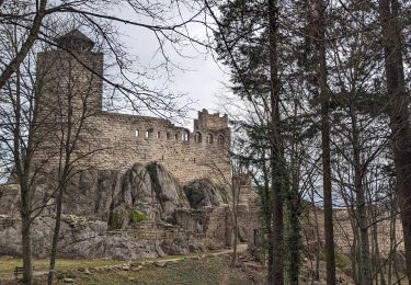
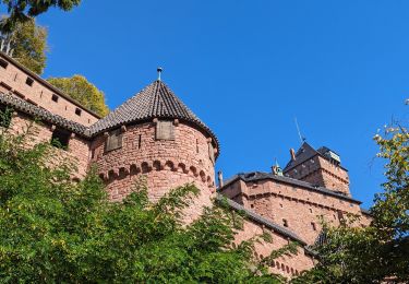
Le départ et l'arrivée ce font à Scherwiller au centre du village, parking à la Mairie et au niveau de l'Eglise. A un moment, vous n'êtes qu'à 400 m du Châteaux de l'Ortenbourg donc un petit crochet s'impose pour ceux qui aiment voir les Châteaux. Vous passerez aussi au Bernstein ( 2x )et oui petite boucle autour de celui-ci. Sinon la première fois maitrisez votre vitesse sur les petits sentiers descendants. Il y a aussi quelques passages techniques ... A Bientôt ! La Grenouille.

Höhenprofil

POIs

POI Scherweiler - Départ - Arrivée. - Photo
tracegps
SCHERWEILER 
POI Scherweiler - Départ. - Photo
tracegps
SCHERWEILER 
POI Scherweiler - S1 - Photo
tracegps
SCHERWEILER 
POI Dambach - S10. - Photo
tracegps
DAMBACH 
POI Dambach - S11. - Photo
tracegps
DAMBACH 
POI Dambach - S12. - Photo
tracegps
DAMBACH 
POI Dambach - S13. - Photo
tracegps
DAMBACH 
POI Dambach - S14. - Photo
tracegps
DAMBACH 
POI Dambach - S15. - Photo
tracegps
DAMBACH 
POI Dambach - S16. - Photo
tracegps
DAMBACH 
POI Dambach - S17. - Photo
tracegps
DAMBACH 
POI Dambach - S18. - Photo
tracegps
DAMBACH 
POI Dambach - S19. - Photo
tracegps
DAMBACH 
POI Scherweiler - S2. - Photo
tracegps
SCHERWEILER 
POI Dambach - S21. - Photo
tracegps
DAMBACH 
POI Dambach - S22. - Photo
tracegps
DAMBACH 
POI Dambach - S23. - Photo
tracegps
DAMBACH 
POI Dambach - S24. - Photo
tracegps
DAMBACH 
POI Dambach - S25. - Photo
tracegps
DAMBACH 
POI Dambach - S26. - Photo
tracegps
DAMBACH 
POI Dambach - S27. - Photo
tracegps
DAMBACH 
POI Dambach - S28. - Photo
tracegps
DAMBACH 
POI Dieffenthal - S29. - Photo
tracegps
DIEFFENTHAL 
POI Scherweiler - S3. - Photo
tracegps
SCHERWEILER 
POI Scherweiler - S30. - Photo
tracegps
SCHERWEILER 
POI Scherweiler - S31. - Photo
tracegps
SCHERWEILER 
POI Scherweiler - S32. - Photo
tracegps
SCHERWEILER 
POI Scherweiler - S33. - Photo
tracegps
SCHERWEILER 
POI Scherweiler - S34. - Photo
tracegps
SCHERWEILER 
POI Scherweiler - S36. - Photo
tracegps
SCHERWEILER 
POI Scherweiler - S37. - Photo
tracegps
SCHERWEILER 
POI Scherweiler - S4. - Photo
tracegps
SCHERWEILER 
POI Scherweiler - S5. - Photo
tracegps
SCHERWEILER 
POI Scherweiler - S6. - Photo
tracegps
SCHERWEILER 
POI Scherweiler - S7. - Photo
tracegps
SCHERWEILER 
POI Dambach - S8. - Photo
tracegps
DAMBACH 
POI Dambach - S9. - Photo
tracegps
DAMBACH 

Ort

Land:
France
Region :
Großer Osten
Abteilung/Provinz :
Unterelsass
Kommune :
Scherweiler
Standort:
Unknown
Gehen Sie:(Dec)
Gehen Sie:(UTM)
382549 ; 5349336 (32U) N.

Kommentare

Bitte melden Sie sich an, um einen Kommentar oder eine Bewertung zu hinterlassen


belle ballade à remettre au programme


Touren in der Umgebung

Tour Wandern Dambach - Les ruines de Bernstein et d'Ortenbourg par la forêt - Photo
Wandern
VacheKiri67

Wandern

Medium
(1)
Dambach, Großer Osten, Unterelsass, France
13 km | 18,5 km-effort
4h 38min
Ja
Tour Wandern Kestenholz - Le Hahnenberg et les balcons Sélestat - Photo
Wandern
VacheKiri67

Wandern

Medium
(2)
Kestenholz, Großer Osten, Unterelsass, France
12 km | 17,2 km-effort
4h 29min
Ja
Tour Wandern Schlettstadt - Sentier de l'Illwald - Photo
Wandern
tracegps

Wandern

Medium
(1)
Schlettstadt, Großer Osten, Unterelsass, France
13,2 km | 14,6 km-effort
3h 45min
Ja
Tour Wandern Kestenholz - Le Haut Koenigsbourg de Val de Ville - Photo
Wandern
tracegps

Wandern

Schwierig
(1)
Kestenholz, Großer Osten, Unterelsass, France
16,8 km | 25 km-effort
5h 0min
Ja
Tour Mountainbike Thannweiler - Circuit de la Gadouille - Photo
Mountainbike
tracegps

Mountainbike

Schwierig
(3)
Thannweiler, Großer Osten, Unterelsass, France
18,4 km | 27 km-effort
1h 40min
Ja
Tour Wandern Dambach - suuntoapp-Hiking-2023-12-26T08-42-47Z - Photo
Wandern
GUIDE
holtzv

Wandern

Sehr schwierig
Dambach, Großer Osten, Unterelsass, France
14,3 km | 21 km-effort
4h 43min
Ja
Tour Wandern Kinzheim - suuntoapp-Hiking-2023-10-15T07-53-44Z - Photo
Wandern
GUIDE
holtzv

Wandern

Medium
Kinzheim, Großer Osten, Unterelsass, France
18,5 km | 28 km-effort
6h 16min
Ja
Tour Wandern Scherweiler - chateau  de ortenbourg - Photo
Wandern
dudu42

Wandern

Sehr leicht
(1)
Scherweiler, Großer Osten, Unterelsass, France
4,6 km | 7,9 km-effort
1h 29min
Ja
Tour Wandern Schlettstadt - Sélestat : balade dans le Ried - Photo
Wandern
Bart2015

Wandern

Schwierig
Schlettstadt, Großer Osten, Unterelsass, France
11,4 km | 12,6 km-effort
2h 51min
Ja


Schließen
Meine Abonnements