![](/images/other/stat-length.png)
![Tour Wandern Théméricourt - Théméricourt-Cléry 04 - Photo](https://media.geolcdn.com/t/1900/400/ext.pjpeg?maxdim=2&url=https%3A%2F%2Fstatic1.geolcdn.com%2Fsiteimages%2Fupload%2Ffiles%2F1553511878bg_sport_marche.png)
Théméricourt-Cléry 04
Claudyo
Benutzer
![Länge](/images/other/stat-length.png)
Länge
17,3 km
![Maximale Höhe](https://static1.geolcdn.com/siteimages/upload/files/1508320355ic_sort_altitude_max_24dp.png)
Maximale Höhe
170 m
![Positive Höhendifferenz](https://static1.geolcdn.com/siteimages/upload/files/1508320355ic_sort_den_pos_24dp.png)
Positive Höhendifferenz
240 m
![Km-Effort](/images/other/stat-length.png)
Km-Effort
21 km
![Min. Höhe](https://static1.geolcdn.com/siteimages/upload/files/1508320355ic_sort_altitude_min_24dp.png)
Min. Höhe
77 m
![Negative Höhendifferenz](https://static1.geolcdn.com/siteimages/upload/files/1508320355ic_sort_den_neg_24dp.png)
Negative Höhendifferenz
240 m
![Boucle](https://static1.geolcdn.com/siteimages/upload/files/16400158638029165_repeat_loop_refresh_sync_direction_icon.png)
Boucle
Ja
Erstellungsdatum :
2019-05-06 14:45:22.956
Letzte Änderung :
2019-05-06 14:45:22.956
![Wandern](https://static1.geolcdn.com/sitytour/trail-icons/101.png)
5h30
Schwierigkeit : Einfach
![Scannen Sie diesen QR-Code, um die Tour in der SityTrail-Anwendung zu öffnen](https://capi.geolives.com/qq0zvz2zws4bq2lad0pu/sitytour/trails/1110677/qr.png?size=200)
Kostenlosegpshiking-Anwendung
Über SityTrail
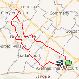
Tour Wandern von 17,3 km verfügbar auf Île-de-France, Val-d'Oise, Théméricourt. Diese Tour wird von Claudyo vorgeschlagen.
Beschreibung
Rendez-vous parking du château de Théméricourt.Départ 09h15. Déjeuner à l'Auberge de Cléry en Vexin 4 grande rue des Tavernes 95420
Ort
Land:
France
Region :
Île-de-France
Abteilung/Provinz :
Val-d'Oise
Kommune :
Théméricourt
Standort:
Unknown
Gehen Sie:(Dec)
Gehen Sie:(UTM)
419387 ; 5437563 (31U) N.
Kommentare
Touren in der Umgebung
![Tour Nordic Walking Frémainville - Forêt de Galluis - Photo](https://media.geolcdn.com/t/375/260/ext.jpg?maxdim=2&url=https%3A%2F%2Fservices.sitytrail.com%2FGeolivesWS%2FDownloadMedia.ashx%3FTrailID%3D171555%26Media%3D20130122104829.jpeg)
![Nordic Walking Nordic Walking](https://static1.geolcdn.com/sitytour/trail-icons/102.png)
Forêt de Galluis
Nordic Walking
Einfach
(1)
Frémainville,
Île-de-France,
Val-d'Oise,
France
![](/images/other/stat-length.png)
6 km | 7,3 km-effort
1h 20min
![](https://static1.geolcdn.com/siteimages/upload/files/16400158638029165_repeat_loop_refresh_sync_direction_icon.png)
Ja
![Tour Wandern Frémainville - Fremainville marche 6km - Photo](https://media.geolcdn.com/t/375/260/ext.jpg?maxdim=2&url=https%3A%2F%2Fservices.sitytrail.com%2FGeolivesWS%2FDownloadMedia.ashx%3FTrailID%3D855665%26Media%3Dfix__20171101170303.jpg)
![Wandern Wandern](https://static1.geolcdn.com/sitytour/trail-icons/101.png)
Fremainville marche 6km
Wandern
Medium
(2)
Frémainville,
Île-de-France,
Val-d'Oise,
France
![](/images/other/stat-length.png)
5,8 km | 7,9 km-effort
1h 20min
![](https://static1.geolcdn.com/siteimages/upload/files/16400158638029165_repeat_loop_refresh_sync_direction_icon.png)
Nein
![Tour Wandern Théméricourt - Théméricourt - La vallée de l''Aubette - Photo](https://media.geolcdn.com/t/375/260/ext.jpg?maxdim=2&url=https%3A%2F%2Fservices.sitytrail.com%2FGeolivesWS%2FDownloadMedia.ashx%3FTrailID%3D158156%26Media%3D9d121a06-3fc5-49da-af2e-21e7dcb3de7b.jpg)
![Wandern Wandern](https://static1.geolcdn.com/sitytour/trail-icons/101.png)
Théméricourt - La vallée de l''Aubette
Wandern
Einfach
(1)
Théméricourt,
Île-de-France,
Val-d'Oise,
France
![](/images/other/stat-length.png)
10,4 km | 12,3 km-effort
2h 42min
![](https://static1.geolcdn.com/siteimages/upload/files/16400158638029165_repeat_loop_refresh_sync_direction_icon.png)
Ja
![Tour Wandern Le Perchay - le perchay etang de valliere santeuil - Photo](https://media.geolcdn.com/t/375/260/ext.jpg?maxdim=2&url=https%3A%2F%2Fstatic1.geolcdn.com%2Fsiteimages%2Fupload%2Ffiles%2F1553511878bg_sport_marche.png)
![Wandern Wandern](https://static1.geolcdn.com/sitytour/trail-icons/101.png)
le perchay etang de valliere santeuil
Wandern
Sehr leicht
(2)
Le Perchay,
Île-de-France,
Val-d'Oise,
France
![](/images/other/stat-length.png)
6,9 km | 8,1 km-effort
1h 34min
![](https://static1.geolcdn.com/siteimages/upload/files/16400158638029165_repeat_loop_refresh_sync_direction_icon.png)
Ja
![Tour Wandern Wy-dit-Joli-Village - Wy dit joli village-Guiry-Gadancourt (boucle) - Photo](https://media.geolcdn.com/t/375/260/ext.jpg?maxdim=2&url=https%3A%2F%2Fstatic1.geolcdn.com%2Fsiteimages%2Fupload%2Ffiles%2F1553511878bg_sport_marche.png)
![Wandern Wandern](https://static1.geolcdn.com/sitytour/trail-icons/101.png)
Wy dit joli village-Guiry-Gadancourt (boucle)
Wandern
Einfach
(1)
Wy-dit-Joli-Village,
Île-de-France,
Val-d'Oise,
France
![](/images/other/stat-length.png)
11,1 km | 13,3 km-effort
2h 32min
![](https://static1.geolcdn.com/siteimages/upload/files/16400158638029165_repeat_loop_refresh_sync_direction_icon.png)
Ja
![Tour Wandern Commeny - Commeny - L'eau et le pain - Photo](https://media.geolcdn.com/t/375/260/ext.jpg?maxdim=2&url=https%3A%2F%2Fstatic1.geolcdn.com%2Fsiteimages%2Fupload%2Ffiles%2F1553511878bg_sport_marche.png)
![Wandern Wandern](https://static1.geolcdn.com/sitytour/trail-icons/101.png)
Commeny - L'eau et le pain
Wandern
Einfach
(4)
Commeny,
Île-de-France,
Val-d'Oise,
France
![](/images/other/stat-length.png)
13,2 km | 15,1 km-effort
3h 18min
![](https://static1.geolcdn.com/siteimages/upload/files/16400158638029165_repeat_loop_refresh_sync_direction_icon.png)
Ja
![Tour Wandern Vigny - Ligny - Photo](https://media.geolcdn.com/t/375/260/ext.jpg?maxdim=2&url=https%3A%2F%2Fmedia.geolcdn.com%2Ff%2F61221f71-66d0-451e-9422-82c8af5b5f85.jpg)
![Wandern Wandern](https://static1.geolcdn.com/sitytour/trail-icons/101.png)
![Tour Wandern Commeny - Kimrny - Photo](https://media.geolcdn.com/t/375/260/ext.jpg?maxdim=2&url=https%3A%2F%2Fmedia.geolcdn.com%2Ff%2Fa8317e30-56ef-42de-9a93-8f11ddeab597.jpg)
![Wandern Wandern](https://static1.geolcdn.com/sitytour/trail-icons/101.png)
Kimrny
Wandern
Sehr leicht
Commeny,
Île-de-France,
Val-d'Oise,
France
![](/images/other/stat-length.png)
13,8 km | 15,7 km-effort
3h 21min
![](https://static1.geolcdn.com/siteimages/upload/files/16400158638029165_repeat_loop_refresh_sync_direction_icon.png)
Ja
![Tour Zu Fuß Le Perchay - Boucle du Perchay - Photo](https://media.geolcdn.com/t/375/260/ext.jpg?maxdim=2&url=https%3A%2F%2Fmedia.geolcdn.com%2Ff%2Fba1e03d7-b6aa-4ec4-93b7-7daeba8cde1e.jpeg)
![Zu Fuß Zu Fuß](https://static1.geolcdn.com/sitytour/trail-icons/100.png)
Boucle du Perchay
Zu Fuß
Einfach
Le Perchay,
Île-de-France,
Val-d'Oise,
France
![](/images/other/stat-length.png)
13,2 km | 15 km-effort
3h 24min
![](https://static1.geolcdn.com/siteimages/upload/files/16400158638029165_repeat_loop_refresh_sync_direction_icon.png)
Ja