Tour Wandern Ully-Saint-Georges - Randonnée d'Ully St Georges - Photo

Randonnée d'Ully St Georges

 tracegps
tracegps

Benutzer

© OpenStreetMap contributors
Länge
Länge
14,5 km
Maximale Höhe
Maximale Höhe
188 m
Positive Höhendifferenz
291 m
Km-Effort
Km-Effort  
18,4 km
Min. Höhe
Min. Höhe
54 m
Negative Höhendifferenz
292 m
Boucle
Boucle
Ja
Erstellungsdatum :
2014-12-10 00:00:00.0
Letzte Änderung :
2014-12-10 00:00:00.0

(2 Nachricht)

Wandern
Wandern
3h40
Schwierigkeit : Schwierig

Scannen Sie diesen QR-Code, um die Tour in der SityTrail-Anwendung zu öffnen

Kostenlosegpshiking-Anwendung

Logo SityTrail SityTrail

IGN / Geografische Institute

SityTrail aus dem App Store herunterladen SityTrail von Google Play herunterladen

Logo SityTrail SityTrail World

Die Welt öffnet sich für Sie

SityTrail aus dem App Store herunterladen SityTrail von Google Play herunterladen SityTrail auf Huawei AppGallery herunterladen

Über SityTrail

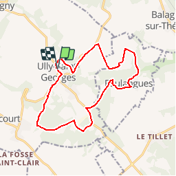
Tour Wandern von 14,5 km verfügbar auf Nordfrankreich, Oise, Ully-Saint-Georges. Diese Tour wird von tracegps vorgeschlagen.

Beschreibung

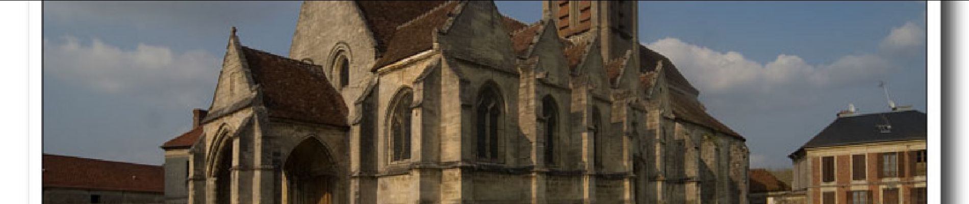
Circuit proposé par la Communauté de Communes du Pays de Thelle. Départ de l’église d’Ully-St-Georges. Retrouver le plan du circuit sur le site de la Communauté de communes du Pays de Thelle. Retrouvez le plan du circuit sur le site de la Communauté de Communes du Pays de Thelle. Ce circuit a été numérisé par les randonneurs du CODEPEM. Merci à Jean-Marie.

Höhenprofil

Foto-Galerie

Ort

Land:
France
Region :
Nordfrankreich
Abteilung/Provinz :
Oise
Kommune :
Ully-Saint-Georges
Standort:
Unknown
Gehen Sie:(Dec)
Gehen Sie:(UTM)
447650 ; 5458807 (31U) N.

Kommentare

Bitte melden Sie sich an, um einen Kommentar oder eine Bewertung zu hinterlassen


Ne pas rater la vallée de Noé une splendeur !


Touren in der Umgebung

Tour Wandern Bury - Bury_Trace GPS_8,9 km - Photo
Wandern
Pousscailleux

Wandern

Medium
(1)
Bury, Nordfrankreich, Oise, France
8,9 km | 11,1 km-effort
2h 25min
Ja
Tour Wandern Ercuis - Ercuis  - Photo
Wandern
Djaie60

Wandern

Einfach
Ercuis, Nordfrankreich, Oise, France
13,3 km | 15,7 km-effort
3h 0min
Ja
Tour Wandern Foulangues - Tour de FOULANGUES  - Photo
Wandern
JEFFV

Wandern

Medium
Foulangues, Nordfrankreich, Oise, France
6,2 km | 7,7 km-effort
1h 50min
Ja
Tour Wandern Ully-Saint-Georges - cavillon ully st georges - Photo
Wandern
magalise

Wandern

Schwierig
Ully-Saint-Georges, Nordfrankreich, Oise, France
12,4 km | 15,7 km-effort
3h 33min
Ja
Tour Wandern Ully-Saint-Georges - ULLY ST GEORGES - Photo
Wandern
Marc ROUSSELOT

Wandern

Sehr schwierig
Ully-Saint-Georges, Nordfrankreich, Oise, France
27 km | 31 km-effort
2h 36min
Nein
Tour sport Ercuis - Ercuis 11.7km - Photo
sport
Djaie60

sport

Sehr leicht
Ercuis, Nordfrankreich, Oise, France
11,7 km | 13,5 km-effort
Unbekannt
Ja
Tour Zu Fuß Ully-Saint-Georges - Cavillon 11.4km - Photo
Zu Fuß
Djaie60

Zu Fuß

Sehr leicht
Ully-Saint-Georges, Nordfrankreich, Oise, France
11,4 km | 13,2 km-effort
Unbekannt
Ja
Tour Zu Fuß Ercuis - Ercuis 11.4km - Photo
Zu Fuß
Djaie60

Zu Fuß

Sehr leicht
Ercuis, Nordfrankreich, Oise, France
11,4 km | 13,6 km-effort
Unbekannt
Ja
Tour Zu Fuß Ercuis - Ercuis 10 km - Photo
Zu Fuß
Djaie60

Zu Fuß

Sehr leicht
Ercuis, Nordfrankreich, Oise, France
10,5 km | 12,1 km-effort
Unbekannt
Ja


Schließen
Meine Abonnements