Tour Wandern Propières - Circuit de Propières - Photo
 tracegps
tracegps

Benutzer

© OpenStreetMap contributors
Länge
Länge
14,3 km
Maximale Höhe
Maximale Höhe
961 m
Positive Höhendifferenz
504 m
Km-Effort
Km-Effort  
21 km
Min. Höhe
Min. Höhe
547 m
Negative Höhendifferenz
504 m
Boucle
Boucle
Ja
Erstellungsdatum :
2014-12-10 00:00:00.0
Letzte Änderung :
2014-12-10 00:00:00.0

(0 Nachricht)

Wandern
Wandern
5h00
Schwierigkeit : Schwierig

Scannen Sie diesen QR-Code, um die Tour in der SityTrail-Anwendung zu öffnen

Kostenlosegpshiking-Anwendung

Logo SityTrail SityTrail

IGN / Geografische Institute

SityTrail aus dem App Store herunterladen SityTrail von Google Play herunterladen

Logo SityTrail SityTrail World

Die Welt öffnet sich für Sie

SityTrail aus dem App Store herunterladen SityTrail von Google Play herunterladen SityTrail auf Huawei AppGallery herunterladen

Über SityTrail

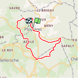
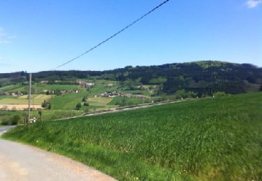
Tour Wandern von 14,3 km verfügbar auf Auvergne-Rhone-Alpen, Rhône, Propières. Diese Tour wird von tracegps vorgeschlagen.

Beschreibung

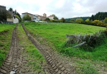
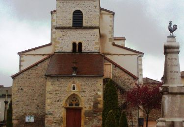
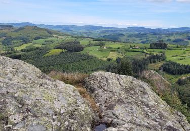
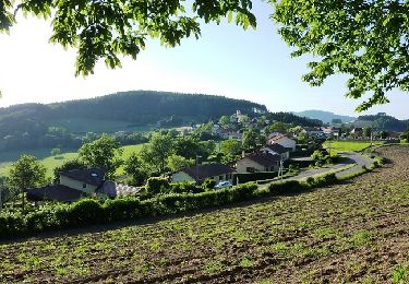
Circuit proposé par l’office de tourisme du Haut-Beaujolais . Niché au pied du massif du Mont Saint Rigaud, le village de Propières est entouré de montagnes et de forêts. Les randonnées alentour offrent de très beaux points de vue sur le village et son église au clocher carré. Vous ferez l'ascension de la roche d'Ajoux depuis laquelle vous admirerez le panorama sur le Brionnais et le Massif Central. D'autres circuits existent autour de Propières, plus faciles ou plus difficiles et sont disponibles sur le site de l'Office de tourisme. Vous pouvez télécharger tous les circuits de Propières en cliquant ICI.

Höhenprofil

Foto-Galerie

Ort

Land:
France
Region :
Auvergne-Rhone-Alpen
Abteilung/Provinz :
Rhône
Kommune :
Propières
Standort:
Unknown
Gehen Sie:(Dec)
Gehen Sie:(UTM)
610919 ; 5116511 (31T) N.

Touren in der Umgebung

Tour Wandern Saint-Germain-la-Montagne - Circuit du Tourniquet - Saint Germain la Montagne - Photo
Wandern
tracegps

Wandern

Schwierig
(1)
Saint-Germain-la-Montagne, Auvergne-Rhone-Alpen, Loire, France
15 km | 22 km-effort
4h 0min
Ja
Tour Zu Fuß Propières - Circuit de Propières n°3 - 15 km - Noir - Photo
Zu Fuß
PRO

Zu Fuß

Medium
Propières, Auvergne-Rhone-Alpen, Rhône, France
14,3 km | 21 km-effort
4h 46min
Ja
Tour Zu Fuß Saint-Clément-de-Vers - Circuit Bleu - Photo
Zu Fuß
PRO

Zu Fuß

Medium
Saint-Clément-de-Vers, Auvergne-Rhone-Alpen, Rhône, France
16,1 km | 23 km-effort
5h 17min
Ja
Tour Zu Fuß Propières - Circuit du Mont Saint-Rigaud 12 km - Photo
Zu Fuß
PRO

Zu Fuß

Einfach
Propières, Auvergne-Rhone-Alpen, Rhône, France
11,8 km | 18,3 km-effort
4h 9min
Ja
Tour Wandern Propières - Séjour RCY journée 4 Les crêtes du Haut Beaujolais  - Photo
Wandern
chessyca

Wandern

Sehr schwierig
Propières, Auvergne-Rhone-Alpen, Rhône, France
28 km | 39 km-effort
6h 48min
Nein
Tour Wandern Saint-Igny-de-Vers - Ajoux (69) - Photo
Wandern
Thomasdanielle

Wandern

Sehr leicht
Saint-Igny-de-Vers, Auvergne-Rhone-Alpen, Rhône, France
16,6 km | 23 km-effort
4h 55min
Ja
Tour Wandern Saint-Igny-de-Vers - Ajoux (69) - Photo
Wandern
Thomasdanielle

Wandern

Einfach
Saint-Igny-de-Vers, Auvergne-Rhone-Alpen, Rhône, France
15,8 km | 23 km-effort
4h 43min
Ja
Tour Mountainbike Saint-Germain-la-Montagne - VTT sportif à travers bois - Saint Germain la Montagne - Photo
Mountainbike
tracegps

Mountainbike

Schwierig
Saint-Germain-la-Montagne, Auvergne-Rhone-Alpen, Loire, France
32 km | 47 km-effort
3h 0min
Ja
Tour Mountainbike Belleroche - Marche de Belleroche - Photo
Mountainbike
balli51

Mountainbike

Schwierig
Belleroche, Auvergne-Rhone-Alpen, Loire, France
33 km | 48 km-effort
2h 59min
Ja


Schließen
Meine Abonnements